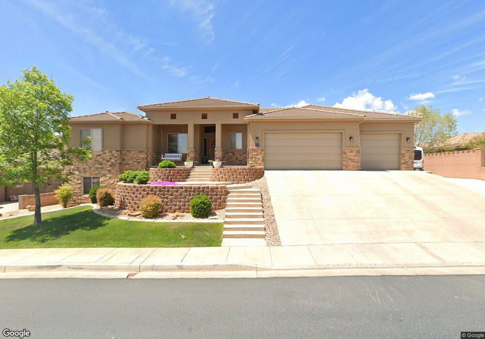
2610 S 1960 E Saint George, UT 84790
Estimated Value: $636,000 - $654,000
4
Beds
3
Baths
3,092
Sq Ft
$209/Sq Ft
Est. Value
About This Home
This home is located at 2610 S 1960 E, Saint George, UT 84790 and is currently estimated at $647,450, approximately $209 per square foot. 2610 S 1960 E is a home located in Washington County with nearby schools including Crimson View Elementary School, Sunrise Ridge Intermediate School, and Desert Hills Middle School.
Ownership History
Date
Name
Owned For
Owner Type
Purchase Details
Closed on
Sep 23, 2025
Sold by
Stoker Katelin M and Stoker Jacob Aaron
Bought by
Jacob And Katelin Stoker Revocable Trust and Stoker
Current Estimated Value
Purchase Details
Closed on
Dec 19, 2019
Sold by
Peacock Bart D and Peacock Vicki L
Bought by
Stoker Katelin M and Stoker Jacob Aaron
Home Financials for this Owner
Home Financials are based on the most recent Mortgage that was taken out on this home.
Original Mortgage
$285,000
Interest Rate
3.6%
Mortgage Type
New Conventional
Purchase Details
Closed on
Mar 10, 2006
Sold by
Peacock Bart D and Peacock Vicki
Bought by
Peacock Bart D and Peacock Vicki L
Home Financials for this Owner
Home Financials are based on the most recent Mortgage that was taken out on this home.
Original Mortgage
$256,000
Interest Rate
6.18%
Mortgage Type
New Conventional
Purchase Details
Closed on
Jan 27, 2005
Sold by
Riggs Family Development Llc
Bought by
Peacock Bart D and Peacock Vicki
Create a Home Valuation Report for This Property
The Home Valuation Report is an in-depth analysis detailing your home's value as well as a comparison with similar homes in the area
Purchase History
| Date | Buyer | Sale Price | Title Company |
|---|---|---|---|
| Jacob And Katelin Stoker Revocable Trust | -- | Accommodation/Courtesy Recordi | |
| Stoker Katelin M | -- | Southern Utah Title Co | |
| Peacock Bart D | -- | Valley Title Co | |
| Peacock Bart D | -- | Southern Utah Title Co |
Source: Public Records
Mortgage History
| Date | Status | Borrower | Loan Amount |
|---|---|---|---|
| Previous Owner | Stoker Katelin M | $285,000 | |
| Previous Owner | Peacock Bart D | $256,000 |
Source: Public Records
Tax History
| Year | Tax Paid | Tax Assessment Tax Assessment Total Assessment is a certain percentage of the fair market value that is determined by local assessors to be the total taxable value of land and additions on the property. | Land | Improvement |
|---|---|---|---|---|
| 2025 | $2,340 | $348,920 | $106,700 | $242,220 |
| 2023 | $2,401 | $358,765 | $90,695 | $268,070 |
| 2022 | $2,454 | $344,740 | $77,385 | $267,355 |
| 2021 | $2,187 | $458,200 | $121,300 | $336,900 |
| 2020 | $1,945 | $383,800 | $101,900 | $281,900 |
| 2019 | $1,881 | $362,700 | $101,900 | $260,800 |
| 2016 | $1,901 | $169,950 | $0 | $0 |
Source: Public Records
Map
Nearby Homes
- 2553 S 2070 E
- 2553 S 2070 E
- 1907 Brisa Ct
- 245 Red Dr Unit 209
- 1373 E White Ln
- 3021 E Banded Dr
- 3141 E 2220 St S Unit 303
- 14 Knettas Knoll Subdivision Unit 14
- 3125 E 2220 S
- 2839 E Horseman Dr
- 959 W Velvet Ridge Cove Unit 1630
- 1226 W Cactus Wren Dr S Unit 179
- 1816 E Boulder Mountain Rd S
- 2827 Circle Dr
- 2434 S 2160 E
- 2345 S 1950 E
- 2208 E 2480 S
- 2247 E Coyote Springs Dr
- 2314 S 1880 E
- 2314 S 1880 St E
- 2626 S 1960 E
- 2594 S 1960 E
- 2569 S Monterosa Ct
- 1976 E 2590 South Cir
- 1981 E 2630 S
- 1981 E 2630 South Cir
- 1976 E 2590 South Cir
- 2638 S 1960 E
- 2576 S 1960 E
- 2518 S Monterosa Ct
- 1980 E 2630 South Cir
- 1977 E 2590 South Cir
- 1980 E 2630 S
- 2568 S Monterosa Ct
- 1995 E 2630 S
- 1995 E 2630 South Cir
- 1992 E 2590 South Cir
- 2516 S 1960 E
- 2652 S 1960 E
- 2560 S 1960 E
Your Personal Tour Guide
Ask me questions while you tour the home.