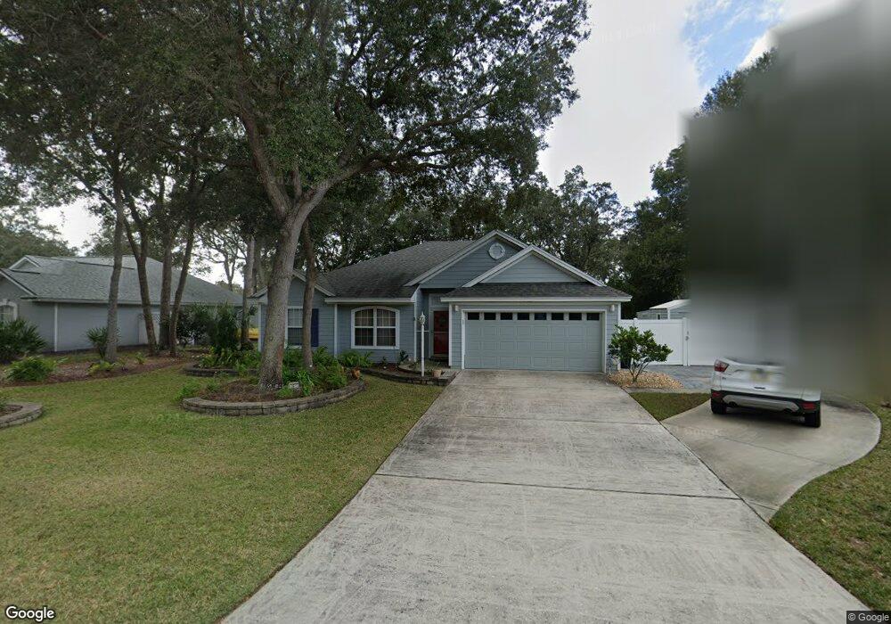
2613 Le Sabre Place Fernandina Beach, FL 32034
Estimated Value: $597,000 - $716,000
3
Beds
2
Baths
1,798
Sq Ft
$355/Sq Ft
Est. Value
About This Home
This home is located at 2613 Le Sabre Place, Fernandina Beach, FL 32034 and is currently estimated at $638,202, approximately $354 per square foot. 2613 Le Sabre Place is a home located in Nassau County with nearby schools including Southside Elementary School, Emma Love Hardee Elementary School, and Fernandina Beach Middle School.
Ownership History
Date
Name
Owned For
Owner Type
Purchase Details
Closed on
Dec 19, 2005
Sold by
Power Patricia A and Power Robert J
Bought by
Mccannell James H and Mccannell Sue C
Current Estimated Value
Purchase Details
Closed on
Apr 30, 2001
Sold by
Zaborek Patsy M and Frank Zaborek E
Bought by
Power Robert J and Power Patricia A
Home Financials for this Owner
Home Financials are based on the most recent Mortgage that was taken out on this home.
Original Mortgage
$148,000
Interest Rate
6.9%
Create a Home Valuation Report for This Property
The Home Valuation Report is an in-depth analysis detailing your home's value as well as a comparison with similar homes in the area
Home Values in the Area
Average Home Value in this Area
Purchase History
| Date | Buyer | Sale Price | Title Company |
|---|---|---|---|
| Mccannell James H | $310,000 | First American Title Ins Co | |
| Power Robert J | $185,000 | Olde Towne Title Company |
Source: Public Records
Mortgage History
| Date | Status | Borrower | Loan Amount |
|---|---|---|---|
| Previous Owner | Power Robert J | $148,000 |
Source: Public Records
Tax History Compared to Growth
Tax History
| Year | Tax Paid | Tax Assessment Tax Assessment Total Assessment is a certain percentage of the fair market value that is determined by local assessors to be the total taxable value of land and additions on the property. | Land | Improvement |
|---|---|---|---|---|
| 2024 | $2,751 | $221,583 | -- | -- |
| 2023 | $2,751 | $215,129 | $0 | $0 |
| 2022 | $2,468 | $207,721 | $0 | $0 |
| 2021 | $2,487 | $201,671 | $0 | $0 |
| 2020 | $2,479 | $198,887 | $0 | $0 |
| 2019 | $2,438 | $194,415 | $0 | $0 |
| 2018 | $2,414 | $191,011 | $0 | $0 |
| 2017 | $2,198 | $187,082 | $0 | $0 |
| 2016 | $2,172 | $183,234 | $0 | $0 |
| 2015 | $2,194 | $181,960 | $0 | $0 |
| 2014 | $2,183 | $180,516 | $0 | $0 |
Source: Public Records
Map
Nearby Homes
- 2133 Taurus Ct
- 2552 Pirates Bay Dr
- 2490 Captain Hook Dr
- 2583 Forest Ridge Dr Unit 3
- 2563 Forest Ridge Dr Unit P3
- 2696 Forest Ridge Dr Unit A6
- 2588 Forest Ridge Dr Unit N-8
- 2105 Purcell Dr
- 2700 Mizell Ave Unit 203B
- 2700 Mizell Ave Unit 504A
- 2700 Mizell Ave Unit 403A
- 2888 Forest Ridge Dr Unit U-8
- 2723 Forest Ridge Dr Unit K3
- 2625 Long Boat Dr
- 2674 Robert Oliver Ave
- 2774 Forest Ridge Dr Unit F4
- 2657 Long Boat Dr
- 2666 Long Boat Dr
- LOT 36 Pirates Bay Dr
- 127 High Rigger Dr
- 2625 Le Sabre Place
- 2547 Le Sabre Place
- 2637 Le Sabre Place
- 2535 Le Sabre Place
- 2512 Caprice Ln
- 2626 Le Sabre Place
- 2602 Le Sabre Place
- 2638 Le Sabre Place
- 2524 Caprice Ln
- 2651 Le Sabre Place
- 2548 Le Sabre Place
- 2500 Caprice Ln
- 2521 Le Sabre Place
- 2638 Caprice Ln
- 2626 Caprice Ln
- 2652 Le Sabre Place
- 2614 Caprice Ln
- 2536 Caprice Ln
- 2659 Le Sabre Place
- 2548 Caprice Ln