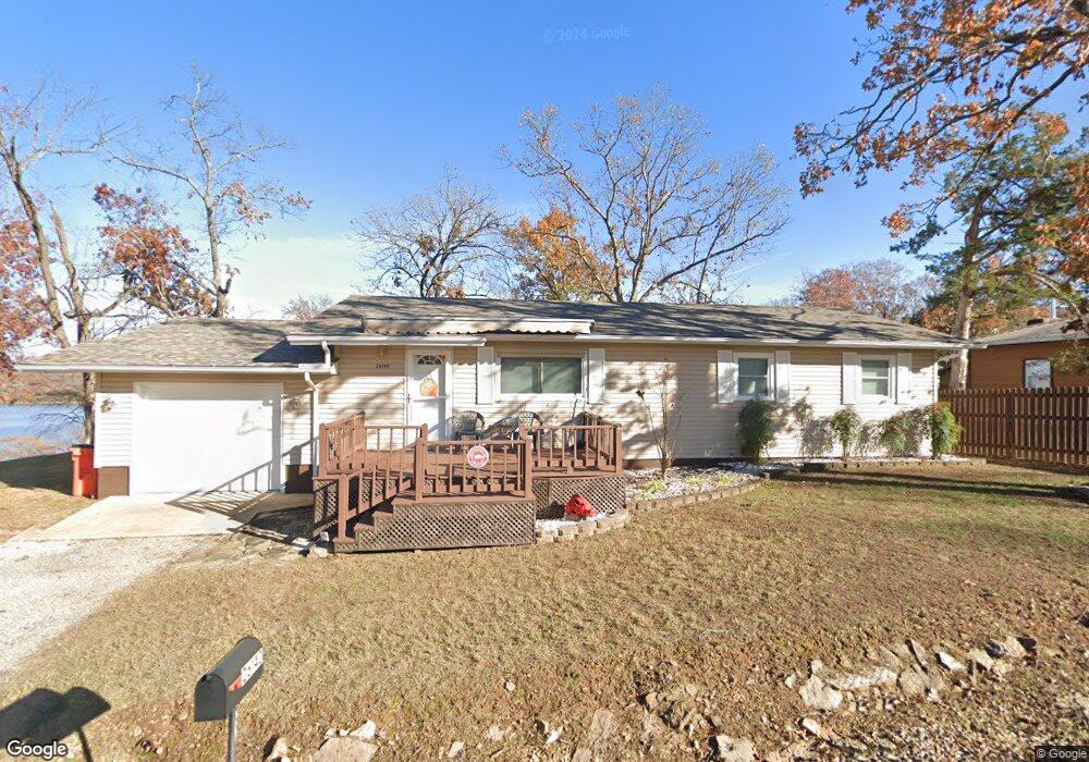
26140 N Royal Point Dr Shell Knob, MO 65747
Estimated Value: $190,597 - $354,000
3
Beds
1
Bath
1,288
Sq Ft
$223/Sq Ft
Est. Value
About This Home
This home is located at 26140 N Royal Point Dr, Shell Knob, MO 65747 and is currently estimated at $287,649, approximately $223 per square foot. 26140 N Royal Point Dr is a home with nearby schools including Eunice Thomas Elementary School, Cassville Intermediate School, and Cassville Middle School.
Ownership History
Date
Name
Owned For
Owner Type
Purchase Details
Closed on
Jun 23, 2010
Sold by
Pelzl Jerome R and Pelzl Margaret
Bought by
Gaddis Robert R and Gaddis Lillian M
Current Estimated Value
Home Financials for this Owner
Home Financials are based on the most recent Mortgage that was taken out on this home.
Original Mortgage
$94,000
Outstanding Balance
$31,170
Interest Rate
4.87%
Mortgage Type
New Conventional
Estimated Equity
$256,479
Purchase Details
Closed on
May 2, 2005
Sold by
Wilson David R and Wilson Janet T
Bought by
Pelzl Jerome R and Pelzl Margaret
Create a Home Valuation Report for This Property
The Home Valuation Report is an in-depth analysis detailing your home's value as well as a comparison with similar homes in the area
Purchase History
| Date | Buyer | Sale Price | Title Company |
|---|---|---|---|
| Gaddis Robert R | -- | Bcat | |
| Pelzl Jerome R | -- | None Available |
Source: Public Records
Mortgage History
| Date | Status | Borrower | Loan Amount |
|---|---|---|---|
| Open | Gaddis Robert R | $94,000 |
Source: Public Records
Tax History
| Year | Tax Paid | Tax Assessment Tax Assessment Total Assessment is a certain percentage of the fair market value that is determined by local assessors to be the total taxable value of land and additions on the property. | Land | Improvement |
|---|---|---|---|---|
| 2025 | $756 | $16,340 | $1,691 | $14,649 |
| 2024 | $8 | $15,029 | $1,691 | $13,338 |
| 2023 | $756 | $15,029 | $1,691 | $13,338 |
| 2022 | $740 | $14,706 | $1,368 | $13,338 |
| 2020 | $694 | $13,623 | $1,368 | $12,255 |
| 2018 | $681 | $13,623 | $1,368 | $12,255 |
| 2017 | $596 | $13,623 | $1,368 | $12,255 |
| 2016 | $569 | $12,863 | $1,216 | $11,647 |
| 2015 | -- | $12,863 | $1,216 | $11,647 |
| 2014 | -- | $12,863 | $1,216 | $11,647 |
| 2012 | -- | $0 | $0 | $0 |
Source: Public Records
Map
Nearby Homes
- 26742 Royal Point Dr
- Tbd Bluff View Rd
- 27014 Pine Bluff Ln
- 26376 Burr Oak Ln
- 25591 Farm Road 2265
- 25953 Fox Woods Cir
- 27111 White Tail Rd
- 27622 Big Rock Rd
- 26629 Bobcat Ln
- 27005 Farm Road 2250
- 25009 Farm Road 2265
- 27512 Old Pace Ln
- 27512 Old Pace Ln
- 27376 Timber Springs Rd
- 27512 W Half of 27512 Old Pace Rd
- Tbd Fairway Dr
- 0 Golden Bay Estates
- 0 Farm Road 1278 Unit 11641116
- Lot 26 Farm Road 1268
- 000 Farm Road 1268 Unit Lot 27
- 26156 N Royal Point Dr
- 26145 N Royal Point Dr
- 26124 N Royal Point Dr
- 26123 N Royal Point Dr
- 26174 N Royal Point Dr
- Tbd Royal Pointe
- 26072 N Royal Point Dr
- 26103 N Royal Point Dr
- Lots 30-32 Royal Pointe
- Tbd 3 Lots North Royal Point
- 26064 N Royal Point Dr
- 26037 N Royal Point Dr Unit Rt 1 Box 1494
- 26052 N Royal Point Dr
- 26920 N Royal Point Dr
- 26717 Royal Point Dr
- 26025 N Royal Point Dr
- 26016 N Royal Point Dr
- 26004 N 26004 Royal Point Dr
- 26004 N Royal Point Dr
- 26684 N Royal Point Dr