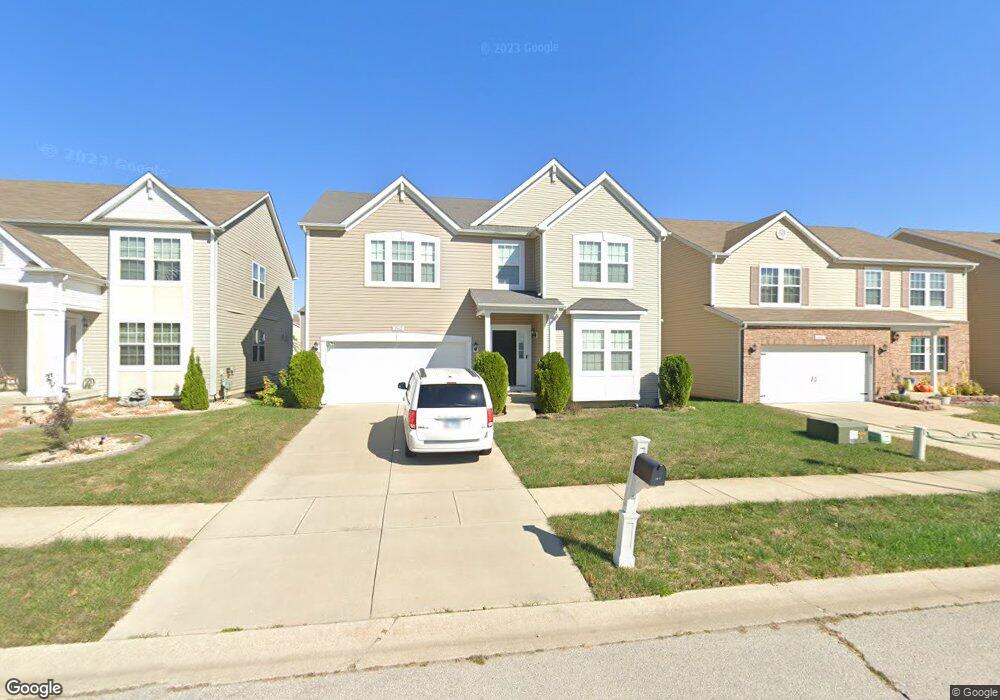
2617 Commons Pkwy Belleville, IL 62221
Estimated Value: $312,308 - $347,000
4
Beds
3
Baths
2,544
Sq Ft
$127/Sq Ft
Est. Value
About This Home
This home is located at 2617 Commons Pkwy, Belleville, IL 62221 and is currently estimated at $324,327, approximately $127 per square foot. 2617 Commons Pkwy is a home located in St. Clair County with nearby schools including Mascoutah High School and Zion Lutheran School Belleville.
Ownership History
Date
Name
Owned For
Owner Type
Purchase Details
Closed on
Mar 31, 2010
Sold by
The Jones Company Homes Llc
Bought by
Miller Jeffrey Ervin
Current Estimated Value
Home Financials for this Owner
Home Financials are based on the most recent Mortgage that was taken out on this home.
Original Mortgage
$151,612
Outstanding Balance
$101,029
Interest Rate
5.01%
Mortgage Type
New Conventional
Estimated Equity
$223,298
Create a Home Valuation Report for This Property
The Home Valuation Report is an in-depth analysis detailing your home's value as well as a comparison with similar homes in the area
Home Values in the Area
Average Home Value in this Area
Purchase History
| Date | Buyer | Sale Price | Title Company |
|---|---|---|---|
| Miller Jeffrey Ervin | $190,000 | Commerce Land Title Inc |
Source: Public Records
Mortgage History
| Date | Status | Borrower | Loan Amount |
|---|---|---|---|
| Open | Miller Jeffrey Ervin | $151,612 |
Source: Public Records
Tax History Compared to Growth
Tax History
| Year | Tax Paid | Tax Assessment Tax Assessment Total Assessment is a certain percentage of the fair market value that is determined by local assessors to be the total taxable value of land and additions on the property. | Land | Improvement |
|---|---|---|---|---|
| 2024 | $6,598 | $90,106 | $11,785 | $78,321 |
| 2023 | $6,308 | $82,207 | $11,551 | $70,656 |
| 2022 | $5,930 | $74,007 | $10,399 | $63,608 |
| 2021 | $5,625 | $68,417 | $9,614 | $58,803 |
| 2020 | $5,425 | $64,700 | $9,092 | $55,608 |
| 2019 | $5,293 | $62,791 | $9,106 | $53,685 |
| 2018 | $5,145 | $61,433 | $8,909 | $52,524 |
| 2017 | $5,211 | $61,001 | $8,847 | $52,154 |
| 2016 | $5,117 | $59,705 | $8,659 | $51,046 |
| 2014 | $4,118 | $55,597 | $7,873 | $47,724 |
| 2013 | $2,534 | $56,393 | $7,986 | $48,407 |
Source: Public Records
Map
Nearby Homes
- 2601 Cedar Grove Dr
- 2709 Cedar Grove Dr
- 2626 Welsch Dr
- 2511 Welsch Dr
- 2619 Waldon Ln
- 1946 Stingray Ct
- 2546 London Ln
- 400 University Dr
- 305 Flagstone Dr
- 2313 College Ave
- 403 Flagstone Dr
- 204 Bittersweet Ln
- 5 Calypso Ct
- 71 Magnolia Dr
- 3233 Scepter Ct
- 3021 Carlyle Ave
- 1301 Springfield Dr
- 3217 Millbrook Dr
- 240 Brookmont Dr
- 3231 Stonebridge Dr
- 2613 Commons Pkwy
- 2609 Commons Pkwy
- 2625 Commons Pkwy
- 2605 Commons Pkwy
- 2629 Commons Pkwy
- 205 Green Leaf Cir
- 121 Meadowcrest Dr
- 200 Greenleaf Cir
- 2621 Commons Pkwy
- 205 Greenleaf Cir
- 120 Meadowcrest Dr
- 2608 Cedar Grove Dr
- 2601 Commons Pkwy
- 2633 Commons Pkwy
- 209 Greenleaf Cir
- 117 Meadowcrest Dr
- 204 Greenleaf Cir
- 116 Meadowcrest Dr
- 2620 Cedar Grove Dr
- 2637 Commons Pkwy