Estimated Value: $577,818 - $727,000
3
Beds
1
Bath
1,687
Sq Ft
$380/Sq Ft
Est. Value
About This Home
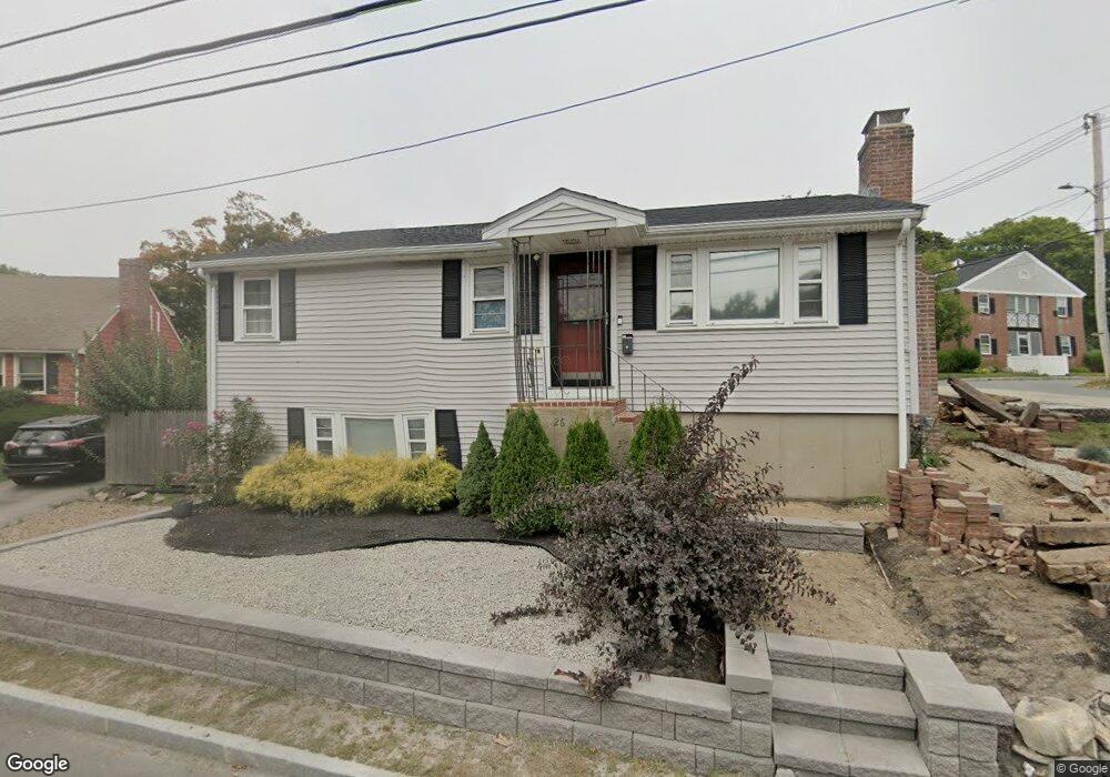
This home is located at 262 Atlantic Ave, Hull, MA 02045 and is currently estimated at $640,705, approximately $379 per square foot. 262 Atlantic Ave is a home located in Plymouth County with nearby schools including Lillian M. Jacobs Elementary School, Memorial Middle School, and Hull High School.
Ownership History
Date
Name
Owned For
Owner Type
Purchase Details
Closed on
Mar 8, 2012
Sold by
Tavino Angelo and Tavino Maria C
Bought by
Tavino Maria C
Current Estimated Value
Purchase Details
Closed on
Oct 29, 2004
Sold by
Ball Stephen J and Rand Kathryn M
Bought by
Tavino Angelo and Tavino Maria
Purchase Details
Closed on
Apr 14, 2004
Sold by
Bonisolli Lisa M and Wilder Lisa M
Bought by
Ball Stephen J and Rand Kathryn M
Purchase Details
Closed on
Jul 27, 2000
Sold by
Mason Steven M
Bought by
Bonisolli Ronald and Wilder Lisa M
Purchase Details
Closed on
May 14, 1999
Sold by
Mason Jeannine M and Mason Richard W
Bought by
Mason Steven M
Purchase Details
Closed on
Aug 7, 1990
Sold by
Est Mason Mary J
Bought by
Mason Richard W
Create a Home Valuation Report for This Property
The Home Valuation Report is an in-depth analysis detailing your home's value as well as a comparison with similar homes in the area
Purchase History
| Date | Buyer | Sale Price | Title Company |
|---|---|---|---|
| Tavino Maria C | -- | -- | |
| Tavino Angelo | $349,000 | -- | |
| Ball Stephen J | $328,000 | -- | |
| Bonisolli Lisa M | -- | -- | |
| Bonisolli Ronald | $190,000 | -- | |
| Mason Steven M | $157,250 | -- | |
| Mason Richard W | $34,000 | -- | |
| Mason Richard W | $34,000 | -- |
Source: Public Records
Mortgage History
| Date | Status | Borrower | Loan Amount |
|---|---|---|---|
| Previous Owner | Mason Richard W | $262,000 | |
| Previous Owner | Mason Richard W | $35,000 |
Source: Public Records
Tax History
| Year | Tax Paid | Tax Assessment Tax Assessment Total Assessment is a certain percentage of the fair market value that is determined by local assessors to be the total taxable value of land and additions on the property. | Land | Improvement |
|---|---|---|---|---|
| 2025 | $4,813 | $429,700 | $188,900 | $240,800 |
| 2024 | $4,737 | $406,600 | $182,400 | $224,200 |
| 2023 | $4,619 | $379,500 | $169,400 | $210,100 |
| 2022 | $4,517 | $360,200 | $161,200 | $199,000 |
| 2021 | $0 | $344,700 | $154,500 | $190,200 |
| 2020 | $4,056 | $316,400 | $154,500 | $161,900 |
| 2019 | $3,939 | $304,000 | $147,800 | $156,200 |
| 2018 | $24,324 | $281,100 | $147,800 | $133,300 |
| 2017 | $24,487 | $258,500 | $134,300 | $124,200 |
| 2016 | $3,485 | $258,500 | $134,300 | $124,200 |
| 2015 | $3,321 | $238,200 | $114,200 | $124,000 |
| 2014 | $3,240 | $233,600 | $114,200 | $119,400 |
Source: Public Records
Map
Nearby Homes
- 99 Nantasket Ave
- 6 State Park Rd Unit 2
- 1 Longbeach Ave Unit 202
- 120 Nantasket Ave Unit 207
- 120 Nantasket Ave Unit 204
- 120 Nantasket Ave Unit 304
- 120 Nantasket Ave Unit PH5
- 120 Nantasket Ave Unit 201
- 62 Oceanside Dr
- 121 Nantasket Ave Unit 503
- 0 Seaview Ave
- 22 Berkley Rd Unit B
- 10 Berkley Rd Unit A
- 37 Richards Rd
- 23 Wyola Rd
- 181 Atlantic Ave
- 6 Montana Ave
- 155 George Washington Blvd Unit 210
- 2 Cliff Rd
- 10 Chestnut Place
- 27 Atlantic House Rd
- 264 Atlantic Ave
- 31 Atlantic House Rd
- 268 Atlantic Ave
- 268 Atlantic Ave Unit B
- 261 Atlantic Ave
- 19 Midledge Ave
- 50 Atlantic House Rd Unit 9F
- 265 Atlantic Ave
- 35 Atlantic House Rd
- 36 Atlantic House Rd
- 274 Atlantic Ave Unit 1
- 274 Atlantic Ave Unit 2
- 21 Midledge Ave
- 25 Midledge Ave
- 38 Atlantic House Rd
- 41 Atlantic House Rd
- 23 Midledge Ave
- 5 State Park Rd Unit 2
- 5 State Park Rd Unit 1
Your Personal Tour Guide
Ask me questions while you tour the home.