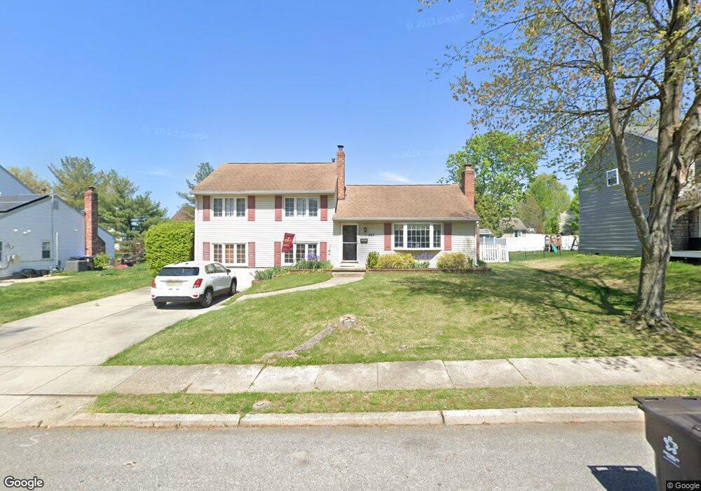
262 Burning Tree Rd Delran, NJ 08075
Tenby Chase NeighborhoodEstimated Value: $448,821 - $476,000
Studio
--
Bath
1,728
Sq Ft
$268/Sq Ft
Est. Value
About This Home
This home is located at 262 Burning Tree Rd, Delran, NJ 08075 and is currently estimated at $462,955, approximately $267 per square foot. 262 Burning Tree Rd is a home located in Burlington County with nearby schools including Millbridge Elementary School, Delran Intermediate School, and Delran Middle School.
Ownership History
Date
Name
Owned For
Owner Type
Purchase Details
Closed on
Oct 28, 2004
Sold by
Williams John C and Williams Meghan
Bought by
Lubicky Edward and Lubicky Megan
Current Estimated Value
Home Financials for this Owner
Home Financials are based on the most recent Mortgage that was taken out on this home.
Original Mortgage
$223,900
Outstanding Balance
$111,510
Interest Rate
5.75%
Mortgage Type
Purchase Money Mortgage
Estimated Equity
$351,445
Purchase Details
Closed on
Dec 30, 1998
Sold by
Baggio George A and Baggio Irene S
Bought by
Williams John C
Home Financials for this Owner
Home Financials are based on the most recent Mortgage that was taken out on this home.
Original Mortgage
$152,898
Interest Rate
6.8%
Mortgage Type
VA
Create a Home Valuation Report for This Property
The Home Valuation Report is an in-depth analysis detailing your home's value as well as a comparison with similar homes in the area
Home Values in the Area
Average Home Value in this Area
Purchase History
| Date | Buyer | Sale Price | Title Company |
|---|---|---|---|
| Lubicky Edward | $279,900 | -- | |
| Williams John C | $149,900 | -- |
Source: Public Records
Mortgage History
| Date | Status | Borrower | Loan Amount |
|---|---|---|---|
| Open | Lubicky Edward | $223,900 | |
| Previous Owner | Williams John C | $152,898 |
Source: Public Records
Tax History
| Year | Tax Paid | Tax Assessment Tax Assessment Total Assessment is a certain percentage of the fair market value that is determined by local assessors to be the total taxable value of land and additions on the property. | Land | Improvement |
|---|---|---|---|---|
| 2025 | $8,572 | $215,600 | $65,000 | $150,600 |
| 2024 | $8,495 | $215,600 | $65,000 | $150,600 |
| 2023 | $8,495 | $215,600 | $65,000 | $150,600 |
| 2022 | $8,385 | $215,600 | $65,000 | $150,600 |
| 2021 | $8,389 | $215,600 | $65,000 | $150,600 |
| 2020 | $8,372 | $215,600 | $65,000 | $150,600 |
| 2019 | $8,294 | $215,600 | $65,000 | $150,600 |
| 2018 | $8,156 | $215,600 | $65,000 | $150,600 |
| 2017 | $8,027 | $215,600 | $65,000 | $150,600 |
| 2016 | $7,908 | $215,600 | $65,000 | $150,600 |
| 2015 | $7,777 | $215,600 | $65,000 | $150,600 |
| 2014 | $7,438 | $215,600 | $65,000 | $150,600 |
Source: Public Records
Map
Nearby Homes
- 247 Southview Dr
- 139 Coopers Kill Rd
- 101 Tarlton Ct
- 124 Coopers Kill Rd
- 207 Farmington Rd
- 120 Coopers Kill Rd
- 2211 Chestnut Hill Dr
- 98 Red Stone Ridge
- 154 Fox Chase Dr
- 123 Shelly Ln
- 2209 New Albany Rd
- 51 Suburban Blvd
- 115 Haines Mill Rd
- 715 Willow Dr
- 70 Suburban Blvd
- 709 Dartmouth Ave
- 100 Diane Ave
- 608 Fountain Ave
- 23 Lehigh Dr
- 108 Patricia Ave
- 264 Burning Tree Rd
- 260 Burning Tree Rd
- 234 Borton Mill Ct
- 232 Borton Mill Ct
- 266 Burning Tree Rd
- 236 Borton Mill Ct
- 263 Burning Tree Rd
- 265 Burning Tree Rd
- 261 Burning Tree Rd
- 268 Burning Tree Rd
- 230 Borton Mill Ct
- 267 Burning Tree Rd
- 233 Sharrow Vale Rd
- 235 Sharrow Vale Rd
- 231 Sharrow Vale Rd
- 237 Sharrow Vale Rd
- 262 Southview Dr
- 220 Sharrow Vale Rd
- 264 Southview Dr
- 260 Southview Dr
Your Personal Tour Guide
Ask me questions while you tour the home.