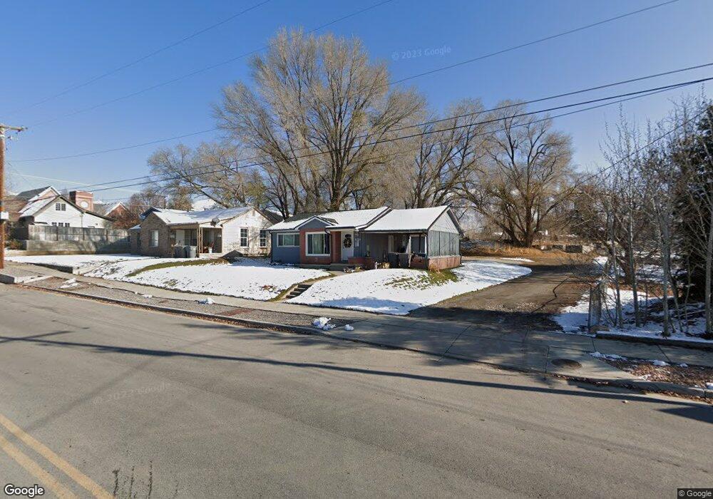
262 N 200 W American Fork, UT 84003
Estimated Value: $387,000 - $449,897
3
Beds
2
Baths
1,520
Sq Ft
$278/Sq Ft
Est. Value
About This Home
This home is located at 262 N 200 W, American Fork, UT 84003 and is currently estimated at $422,974, approximately $278 per square foot. 262 N 200 W is a home located in Utah County with nearby schools including Shelley Elementary School, American Fork Junior High School, and American Fork High School.
Ownership History
Date
Name
Owned For
Owner Type
Purchase Details
Closed on
Mar 13, 2020
Sold by
Cornaby Thomas
Bought by
Cornaby Thomas C and Cornaby Marci A
Current Estimated Value
Home Financials for this Owner
Home Financials are based on the most recent Mortgage that was taken out on this home.
Original Mortgage
$191,250
Outstanding Balance
$169,056
Interest Rate
3.4%
Mortgage Type
New Conventional
Estimated Equity
$253,918
Purchase Details
Closed on
May 27, 2005
Sold by
Anderson Carl B
Bought by
Cornaby Thomas C and Cornaby Marci A
Home Financials for this Owner
Home Financials are based on the most recent Mortgage that was taken out on this home.
Original Mortgage
$134,735
Interest Rate
5.72%
Mortgage Type
VA
Purchase Details
Closed on
Jan 27, 2000
Sold by
Bullock Joseph H and Bullock Dixie C
Bought by
Anderson Carl B
Home Financials for this Owner
Home Financials are based on the most recent Mortgage that was taken out on this home.
Original Mortgage
$83,200
Interest Rate
7.87%
Mortgage Type
Balloon
Purchase Details
Closed on
Nov 7, 1997
Sold by
Bullock Joseph H
Bought by
Bullock Joseph H and Bullock Dixie C
Create a Home Valuation Report for This Property
The Home Valuation Report is an in-depth analysis detailing your home's value as well as a comparison with similar homes in the area
Home Values in the Area
Average Home Value in this Area
Purchase History
| Date | Buyer | Sale Price | Title Company |
|---|---|---|---|
| Cornaby Thomas C | -- | Accommodation | |
| Cornaby Thomas | -- | Gt Title Services | |
| Cornaby Thomas C | -- | Equity Title | |
| Anderson Carl B | -- | Guardian Title Insurance | |
| Bullock Joseph H | -- | -- |
Source: Public Records
Mortgage History
| Date | Status | Borrower | Loan Amount |
|---|---|---|---|
| Open | Cornaby Thomas | $191,250 | |
| Closed | Cornaby Thomas C | $134,735 | |
| Previous Owner | Anderson Carl B | $83,200 | |
| Closed | Anderson Carl B | $20,800 |
Source: Public Records
Tax History Compared to Growth
Tax History
| Year | Tax Paid | Tax Assessment Tax Assessment Total Assessment is a certain percentage of the fair market value that is determined by local assessors to be the total taxable value of land and additions on the property. | Land | Improvement |
|---|---|---|---|---|
| 2025 | $1,717 | $209,275 | $179,900 | $200,600 |
| 2024 | $1,717 | $190,740 | $0 | $0 |
| 2023 | $1,606 | $189,145 | $0 | $0 |
| 2022 | $1,629 | $189,420 | $0 | $0 |
| 2021 | $1,389 | $252,200 | $129,100 | $123,100 |
| 2020 | $1,296 | $228,200 | $115,300 | $112,900 |
| 2019 | $1,162 | $211,700 | $98,800 | $112,900 |
| 2018 | $1,120 | $195,000 | $88,900 | $106,100 |
| 2017 | $1,066 | $100,210 | $0 | $0 |
| 2016 | $1,063 | $92,840 | $0 | $0 |
| 2015 | $1,033 | $85,635 | $0 | $0 |
| 2014 | $976 | $79,750 | $0 | $0 |
Source: Public Records
Map
Nearby Homes
- 105 N 100 W
- 129 W Pacific Dr
- 370 W Pacific Dr Unit 1
- 374 N Center St
- 120 N 350 W Unit 127
- 120 N 350 W Unit 133
- 120 N 350 W Unit 130
- 540 N 300 W
- 356 N 480 W
- 396 N 100 E
- 148 N 100 E
- 55 S 200 W
- 414 N 100 E
- 136 E 170 N
- 621 N 100 W
- 217 W Main St
- 146 N Grant Ave
- 351 Washington Ave
- 82 S Lincoln Ave
- 55 Roosevelt Ave