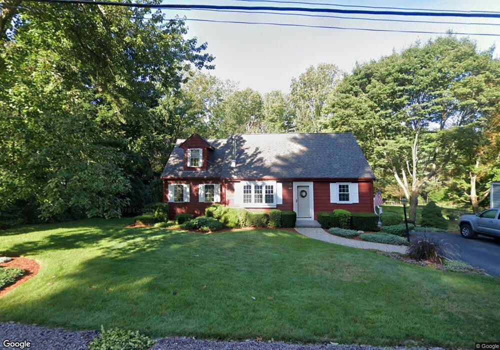
262 Taunton St Wrentham, MA 02093
Estimated Value: $596,383 - $648,000
2
Beds
2
Baths
1,570
Sq Ft
$395/Sq Ft
Est. Value
About This Home
This home is located at 262 Taunton St, Wrentham, MA 02093 and is currently estimated at $620,846, approximately $395 per square foot. 262 Taunton St is a home located in Norfolk County with nearby schools including Delaney Elementary School, Charles E Roderick, and Cadence Academy Preschool - North Attleborough.
Ownership History
Date
Name
Owned For
Owner Type
Purchase Details
Closed on
Mar 19, 1979
Bought by
Oberlander Peter H and Oberlander Linda L
Current Estimated Value
Create a Home Valuation Report for This Property
The Home Valuation Report is an in-depth analysis detailing your home's value as well as a comparison with similar homes in the area
Home Values in the Area
Average Home Value in this Area
Purchase History
| Date | Buyer | Sale Price | Title Company |
|---|---|---|---|
| Oberlander Peter H | -- | -- |
Source: Public Records
Mortgage History
| Date | Status | Borrower | Loan Amount |
|---|---|---|---|
| Closed | Oberlander Peter H | $29,000 |
Source: Public Records
Tax History Compared to Growth
Tax History
| Year | Tax Paid | Tax Assessment Tax Assessment Total Assessment is a certain percentage of the fair market value that is determined by local assessors to be the total taxable value of land and additions on the property. | Land | Improvement |
|---|---|---|---|---|
| 2025 | $5,699 | $491,700 | $252,000 | $239,700 |
| 2024 | $5,453 | $454,400 | $252,000 | $202,400 |
| 2023 | $5,329 | $422,300 | $229,100 | $193,200 |
| 2022 | $4,996 | $365,500 | $206,200 | $159,300 |
| 2021 | $4,719 | $335,400 | $184,200 | $151,200 |
| 2020 | $4,911 | $344,600 | $168,100 | $176,500 |
| 2019 | $4,520 | $320,100 | $152,800 | $167,300 |
| 2018 | $4,275 | $300,200 | $152,900 | $147,300 |
| 2017 | $4,016 | $281,800 | $150,000 | $131,800 |
| 2016 | $4,006 | $280,500 | $145,600 | $134,900 |
| 2015 | $3,874 | $258,600 | $140,000 | $118,600 |
| 2014 | $3,809 | $248,800 | $134,600 | $114,200 |
Source: Public Records
Map
Nearby Homes
- 319 Taunton St
- 10 Nature View Dr
- 15 Nature View Dr
- 11 Earle Stewart Ln
- Lot 1 - Blueberry 2 Car Plan at King Philip Estates
- Lot 8 - Blueberry 2 Car Plan at King Philip Estates
- Lot 5 - Hughes 2 car Plan at King Philip Estates
- Lot 6 - Blueberry 3 Car Plan at King Philip Estates
- Lot 2 - Camden 2 Car Plan at King Philip Estates
- Lot 7 - Cedar Plan at King Philip Estates
- Lot 4 - Hemingway 2 Car Plan at King Philip Estates
- Lot 3 - Blueberry 2 Car Plan at King Philip Estates
- Lot 3 - 14 Earle Stewart Ln
- 131 Creek St Unit 7
- 362 East St
- 1 Lorraine Metcalf Dr
- 120 Hawes St
- 791 South St Unit 5
- 270 Dedham St
- 483 Thurston St
- 256 Taunton St
- 268 Taunton St
- 248 Taunton St
- 276 Taunton St
- 277 Taunton St
- 242 Taunton St
- 288 Taunton St
- 267 Taunton St
- 236 Taunton St
- 249 Taunton St
- 290 Taunton St
- 239 Taunton St
- 298 Taunton St
- 295 Taunton St
- 235 Taunton St
- 226 Taunton St
- 224 Taunton St Unit 224
- 224 Taunton St Unit 1
- 224 Taunton St
- 224 Taunton St