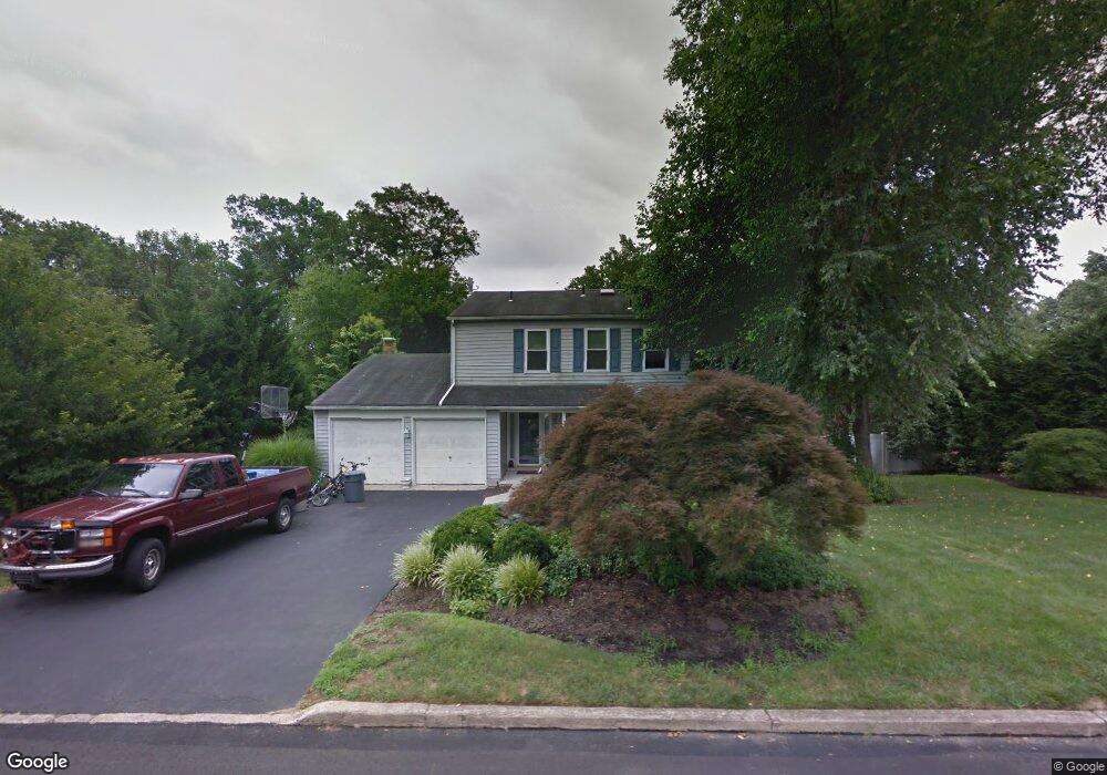
262 Wheatsheaf Ln Langhorne, PA 19047
Estimated Value: $632,000 - $679,309
4
Beds
3
Baths
2,208
Sq Ft
$297/Sq Ft
Est. Value
About This Home
This home is located at 262 Wheatsheaf Ln, Langhorne, PA 19047 and is currently estimated at $655,577, approximately $296 per square foot. 262 Wheatsheaf Ln is a home located in Bucks County with nearby schools including Pearl S. Buck Elementary School, Maple Point Middle School, and Neshaminy High School.
Ownership History
Date
Name
Owned For
Owner Type
Purchase Details
Closed on
Oct 17, 2023
Sold by
Burns Robert M
Bought by
Burns Robert M and Burns Ellen P
Current Estimated Value
Purchase Details
Closed on
Nov 22, 2006
Sold by
Burns Robert M and Burns Michelle M
Bought by
Burns Robert M
Home Financials for this Owner
Home Financials are based on the most recent Mortgage that was taken out on this home.
Original Mortgage
$340,000
Interest Rate
6.4%
Mortgage Type
New Conventional
Purchase Details
Closed on
Nov 30, 2000
Sold by
Burns Robert F and Burns Connie L
Bought by
Burns Robert M and Burns Michelle M
Home Financials for this Owner
Home Financials are based on the most recent Mortgage that was taken out on this home.
Original Mortgage
$199,200
Interest Rate
7.64%
Create a Home Valuation Report for This Property
The Home Valuation Report is an in-depth analysis detailing your home's value as well as a comparison with similar homes in the area
Home Values in the Area
Average Home Value in this Area
Purchase History
| Date | Buyer | Sale Price | Title Company |
|---|---|---|---|
| Burns Robert M | -- | None Listed On Document | |
| Burns Robert M | -- | None Available | |
| Burns Robert M | $249,000 | -- |
Source: Public Records
Mortgage History
| Date | Status | Borrower | Loan Amount |
|---|---|---|---|
| Previous Owner | Burns Robert M | $340,000 | |
| Previous Owner | Burns Robert M | $199,200 |
Source: Public Records
Tax History Compared to Growth
Tax History
| Year | Tax Paid | Tax Assessment Tax Assessment Total Assessment is a certain percentage of the fair market value that is determined by local assessors to be the total taxable value of land and additions on the property. | Land | Improvement |
|---|---|---|---|---|
| 2025 | $8,935 | $41,040 | $8,200 | $32,840 |
| 2024 | $8,935 | $41,040 | $8,200 | $32,840 |
| 2023 | $8,793 | $41,040 | $8,200 | $32,840 |
| 2022 | $8,562 | $41,040 | $8,200 | $32,840 |
| 2021 | $8,562 | $41,040 | $8,200 | $32,840 |
| 2020 | $8,459 | $41,040 | $8,200 | $32,840 |
| 2019 | $8,270 | $41,040 | $8,200 | $32,840 |
| 2018 | $8,119 | $41,040 | $8,200 | $32,840 |
| 2017 | $7,911 | $41,040 | $8,200 | $32,840 |
| 2016 | $7,911 | $41,040 | $8,200 | $32,840 |
| 2015 | $8,101 | $41,040 | $8,200 | $32,840 |
| 2014 | $8,101 | $41,040 | $8,200 | $32,840 |
Source: Public Records
Map
Nearby Homes
- 292 Old Mill Dr
- 413 N Pine St
- 409 N Pine St
- 103 Garrison Ct
- 623 Saint James Ct
- 256 E Marshall Ave
- 24 Tupelo Ln
- 239 N Pine St
- 30 Tupelo Ln
- 1650 Janney Terrace
- 126 N Green St
- 308 W Richardson Ave
- 137 Coach Rd
- 624 Lollard Ct
- 35 Hanover Ct
- 1021 W Maple Ave
- 311 Kyle Ln Unit HOMESITE 101
- 311 Kyle Ln
- 315 Kyle Ln
- 315 Kyle Ln Unit HOMESITE 103
- 252 Wheatsheaf Ln
- 274 Wheatsheaf Ln
- 263 Wheatsheaf Ln
- 251 Wheatsheaf Ln
- 301 Old Mill Dr
- 246 Wheatsheaf Ln
- 286 Wheatsheaf Ln
- 273 Wheatsheaf Ln
- 319 Old Mill Dr
- 261 Old Mill Dr
- 285 Wheatsheaf Ln
- 241 Wheatsheaf Ln
- 236 Wheatsheaf Ln
- 296 Wheatsheaf Ln
- 252 Flour Ln
- 264 Flour Ln
- 327 Old Mill Dr
- 274 Flour Ln
- 295 Wheatsheaf Ln
- 286 Flour Ln