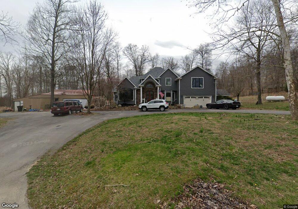
2621 E Radio Tower Rd Scottsburg, IN 47170
Estimated Value: $376,000 - $450,045
3
Beds
3
Baths
2,732
Sq Ft
$152/Sq Ft
Est. Value
About This Home
This home is located at 2621 E Radio Tower Rd, Scottsburg, IN 47170 and is currently estimated at $414,011, approximately $151 per square foot. 2621 E Radio Tower Rd is a home located in Scott County with nearby schools including Scottsburg Senior High School.
Ownership History
Date
Name
Owned For
Owner Type
Purchase Details
Closed on
Nov 1, 2006
Sold by
Mcgehee Chris
Bought by
Sanders Robert and Sanders Edie
Current Estimated Value
Home Financials for this Owner
Home Financials are based on the most recent Mortgage that was taken out on this home.
Original Mortgage
$83,200
Outstanding Balance
$56,440
Interest Rate
8.99%
Mortgage Type
Adjustable Rate Mortgage/ARM
Estimated Equity
$357,571
Create a Home Valuation Report for This Property
The Home Valuation Report is an in-depth analysis detailing your home's value as well as a comparison with similar homes in the area
Home Values in the Area
Average Home Value in this Area
Purchase History
| Date | Buyer | Sale Price | Title Company |
|---|---|---|---|
| Sanders Robert | -- | None Available |
Source: Public Records
Mortgage History
| Date | Status | Borrower | Loan Amount |
|---|---|---|---|
| Open | Sanders Robert | $83,200 |
Source: Public Records
Tax History Compared to Growth
Tax History
| Year | Tax Paid | Tax Assessment Tax Assessment Total Assessment is a certain percentage of the fair market value that is determined by local assessors to be the total taxable value of land and additions on the property. | Land | Improvement |
|---|---|---|---|---|
| 2024 | $3,245 | $327,800 | $30,000 | $297,800 |
| 2023 | $2,867 | $300,100 | $30,000 | $270,100 |
| 2022 | $2,874 | $290,800 | $30,000 | $260,800 |
| 2021 | $2,657 | $261,500 | $30,000 | $231,500 |
| 2020 | $2,595 | $264,300 | $30,000 | $234,300 |
| 2019 | $2,303 | $237,300 | $30,000 | $207,300 |
| 2018 | $2,248 | $233,100 | $25,700 | $207,400 |
| 2017 | $2,151 | $233,400 | $25,700 | $207,700 |
| 2016 | $2,098 | $228,700 | $25,700 | $203,000 |
| 2014 | $2,044 | $216,900 | $25,700 | $191,200 |
| 2013 | $2,044 | $182,000 | $25,700 | $156,300 |
Source: Public Records
Map
Nearby Homes
- 4551 S Slate Ford Rd
- 5732 S Maplewood Dr
- 2198 E State Road 356
- 304 Smith Rd
- 22826 East St
- 22909 West St
- 544 E Hilltop Dr
- 22811 Highway 31 S
- 2138 S Leslie Ln
- 3518 S Robbins Rd
- 3528 S Robbins Rd
- 0 W Leota Rd
- 1625 Old State Rd
- 1357 N 3
- 1020 S Goshen Rd
- 969 S Goshen Rd
- 138 E Lovers Ln
- 8800 block Henryville Otisco Rd
- 129 E Larry Ln
- 1166 S Riley Dr
- 2458 E Radio Tower Rd
- 2452 E Radio Tower Rd
- 2583 E Radio Tower Rd
- 5033 S Sommerville Rd
- 5106 S Sommerville Rd
- 2455 E Radio Tower Rd
- 2349 Minnix Ct
- 2376 E Radio Tower Rd
- 2333 Minnix Ct
- 2417 Minnix Ct
- 4748 S Sommerville Rd
- 2300 Minnix Ct
- 4731 S Sommerville Rd
- 5249 S Sommerville Rd
- 2299 E Radio Tower Rd
- 2292 E Radio Tower Rd
- 2455 E Minnix Dr
- 2395 E Minnix Dr
- 2239 E Radio Tower Rd
- 5277 S Sommerville Rd