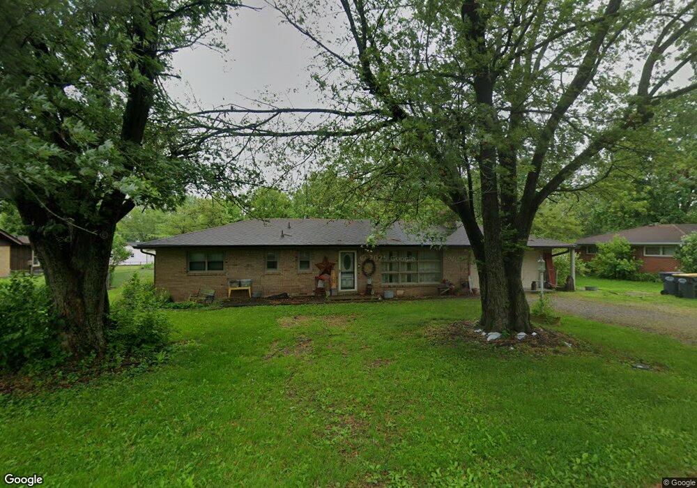
2621 W 39th St Anderson, IN 46011
Estimated Value: $200,000 - $217,701
3
Beds
2
Baths
1,564
Sq Ft
$133/Sq Ft
Est. Value
About This Home
This home is located at 2621 W 39th St, Anderson, IN 46011 and is currently estimated at $208,675, approximately $133 per square foot. 2621 W 39th St is a home located in Madison County with nearby schools including Anderson Elementary School, Highland Middle School, and Anderson High School.
Ownership History
Date
Name
Owned For
Owner Type
Purchase Details
Closed on
Dec 5, 2019
Sold by
Mcatee Jeremiah and Warrum Marjorie
Bought by
Mcatee Jeremiah
Current Estimated Value
Home Financials for this Owner
Home Financials are based on the most recent Mortgage that was taken out on this home.
Original Mortgage
$89,031
Outstanding Balance
$78,904
Interest Rate
3.87%
Mortgage Type
FHA
Estimated Equity
$129,771
Purchase Details
Closed on
Aug 10, 2010
Sold by
Warrum David Marjorie
Bought by
Mcatee Jeremiah and Wirrum Marjorie
Purchase Details
Closed on
Mar 21, 2008
Sold by
Boze Karen
Bought by
Warrum David and Warrum Marjorie
Home Financials for this Owner
Home Financials are based on the most recent Mortgage that was taken out on this home.
Original Mortgage
$67,441
Interest Rate
5.79%
Mortgage Type
FHA
Create a Home Valuation Report for This Property
The Home Valuation Report is an in-depth analysis detailing your home's value as well as a comparison with similar homes in the area
Home Values in the Area
Average Home Value in this Area
Purchase History
| Date | Buyer | Sale Price | Title Company |
|---|---|---|---|
| Mcatee Jeremiah | -- | None Available | |
| Mcatee Jeremiah | -- | None Available | |
| Warrum David | -- | -- |
Source: Public Records
Mortgage History
| Date | Status | Borrower | Loan Amount |
|---|---|---|---|
| Open | Mcatee Jeremiah | $89,031 | |
| Previous Owner | Warrum David | $67,441 |
Source: Public Records
Tax History Compared to Growth
Tax History
| Year | Tax Paid | Tax Assessment Tax Assessment Total Assessment is a certain percentage of the fair market value that is determined by local assessors to be the total taxable value of land and additions on the property. | Land | Improvement |
|---|---|---|---|---|
| 2024 | $1,282 | $118,400 | $16,600 | $101,800 |
| 2023 | $1,177 | $108,500 | $15,800 | $92,700 |
| 2022 | $1,174 | $108,600 | $15,000 | $93,600 |
| 2021 | $1,079 | $100,000 | $14,800 | $85,200 |
| 2020 | $997 | $92,700 | $14,100 | $78,600 |
| 2019 | $1,001 | $106,900 | $14,100 | $92,800 |
| 2018 | $915 | $84,000 | $14,100 | $69,900 |
| 2017 | $846 | $84,000 | $14,100 | $69,900 |
| 2016 | $846 | $97,400 | $14,100 | $83,300 |
| 2014 | $905 | $89,300 | $13,900 | $75,400 |
| 2013 | $905 | $89,300 | $13,900 | $75,400 |
Source: Public Records
Map
Nearby Homes
- 2628 W 39th St
- 3905 Doctor Martin Luther King Junior Blvd
- 421 Enchanted Dr
- 4609 Doctor Martin Luther King Junior Blvd
- 2401 W 27th St
- 5330 Dr Martin Luther King jr Blvd
- 912 Crescent Dr
- 614 W 34th St
- 706 Lonsvale Dr
- 0 Fairview Dr Unit MBR22021213
- 0 Fairview Dr Unit MBR22021211
- 4413 Brenda Dr
- 2121 Euclid Dr
- 0 Oak Ct Unit LotWP001 24609107
- 0 Oak Ct Unit MBR22059682
- 508 Andover Rd
- 3121 Sherman St
- 0 Fulton St Unit MBR22051501
- 814 Rustic Rd
- 606 S Buckingham Ct Unit 8-B