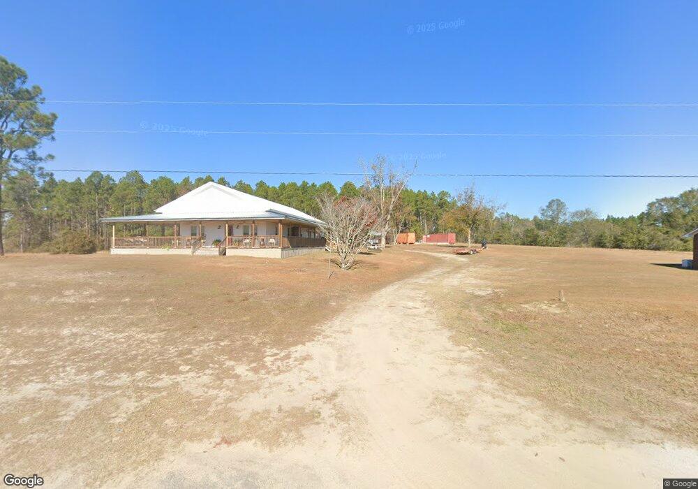
2622 Us Highway 80 W Adrian, GA 31002
Estimated Value: $178,000 - $278,000
3
Beds
1
Bath
2,314
Sq Ft
$105/Sq Ft
Est. Value
About This Home
This home is located at 2622 Us Highway 80 W, Adrian, GA 31002 and is currently estimated at $243,770, approximately $105 per square foot. 2622 Us Highway 80 W is a home located in Emanuel County with nearby schools including Swainsboro High School.
Ownership History
Date
Name
Owned For
Owner Type
Purchase Details
Closed on
Oct 28, 2019
Sold by
Anderson Frances D
Bought by
Douglas Michael R
Current Estimated Value
Home Financials for this Owner
Home Financials are based on the most recent Mortgage that was taken out on this home.
Original Mortgage
$66,054
Interest Rate
3.6%
Mortgage Type
New Conventional
Purchase Details
Closed on
Jun 6, 2002
Sold by
Douglas Roy C and Douglas Magg
Bought by
Douglas Roy C and Douglas Magg
Create a Home Valuation Report for This Property
The Home Valuation Report is an in-depth analysis detailing your home's value as well as a comparison with similar homes in the area
Home Values in the Area
Average Home Value in this Area
Purchase History
| Date | Buyer | Sale Price | Title Company |
|---|---|---|---|
| Douglas Michael R | $85,000 | -- | |
| Douglas Roy C | -- | -- |
Source: Public Records
Mortgage History
| Date | Status | Borrower | Loan Amount |
|---|---|---|---|
| Closed | Douglas Michael R | $66,054 |
Source: Public Records
Tax History Compared to Growth
Tax History
| Year | Tax Paid | Tax Assessment Tax Assessment Total Assessment is a certain percentage of the fair market value that is determined by local assessors to be the total taxable value of land and additions on the property. | Land | Improvement |
|---|---|---|---|---|
| 2024 | $1,851 | $75,645 | $14,893 | $60,752 |
| 2023 | $1,696 | $65,385 | $11,702 | $53,684 |
| 2022 | $712 | $31,510 | $11,702 | $19,808 |
| 2021 | $683 | $29,113 | $10,638 | $18,475 |
| 2020 | $655 | $32,445 | $16,620 | $15,825 |
| 2019 | $651 | $32,562 | $16,620 | $15,942 |
| 2018 | $937 | $32,562 | $16,620 | $15,942 |
| 2017 | $912 | $31,630 | $16,620 | $15,010 |
| 2016 | $376 | $31,386 | $16,620 | $14,766 |
| 2015 | -- | $31,193 | $16,428 | $14,766 |
| 2014 | -- | $30,195 | $16,428 | $13,767 |
| 2013 | -- | $29,923 | $16,426 | $13,497 |
Source: Public Records
Map
Nearby Homes
- 0000 Hwy 171
- 0 Old Wilson Rd
- Old Wilson Rd
- 223 Kersey Rd
- 87 Georgia Ave
- 600 Alton Lawson Rd
- 400 Alton Lawson Rd
- 503 Alton Lawson Rd
- 0 Alton Lawson Rd
- 546 Alton Lawson Rd
- 0 Trinity Church Rd
- 150 Kemp Rd
- 444 Halls Bridge Rd
- 0 Cow Ford Bridge Rd Unit 10535184
- 0 Cow Ford Bridge Rd Unit 24270147
- 374 Union Chapel Rd
- S Highway 56
- 0 Walden Way Unit 10601502
- 0 Asa Lindsey Rd Unit 10595336
- 0 Asa Lindsey Rd Unit 25496504
- 2592 Us Highway 80 W
- 2563 Us Highway 80 W
- 0 N Highway 221
- 257 Odomville Church Rd
- 259 Odomville Church Rd
- 351 Odomville Church Rd
- 15 Arthur Hutcheson Rd
- 11 Arthur Hutcheson Rd
- 19 Cow Ford Bridge Rd
- 34 da Sapp Ln
- 2711 Us Highway 80 W
- 2711 West St
- 2711 U S 80
- 307 Odomville Church Rd
- 10 Arthur Hutcheson Rd
- 272 Odomville Church Rd
- 17 Arthur Hutcheson Rd
- 708 Ga Highway 15 S
- 249 Odomville Church Rd
- 221 S Highway 221 St