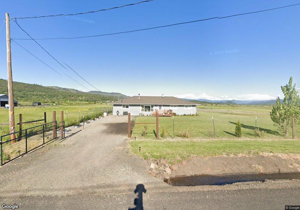
2625 Ball Rd Eagle Point, OR 97524
Estimated Value: $486,000 - $724,000
4
Beds
2
Baths
3,078
Sq Ft
$211/Sq Ft
Est. Value
About This Home
This home is located at 2625 Ball Rd, Eagle Point, OR 97524 and is currently estimated at $649,955, approximately $211 per square foot. 2625 Ball Rd is a home located in Jackson County with nearby schools including Eagle Rock Elementary School, Eagle Point Middle School, and White Mountain Middle School.
Ownership History
Date
Name
Owned For
Owner Type
Purchase Details
Closed on
Feb 27, 2023
Sold by
Salmon Falls Inc
Bought by
Legendary Excavation Llc
Current Estimated Value
Home Financials for this Owner
Home Financials are based on the most recent Mortgage that was taken out on this home.
Original Mortgage
$878,000
Outstanding Balance
$413,691
Interest Rate
6.15%
Mortgage Type
Seller Take Back
Estimated Equity
$236,264
Purchase Details
Closed on
Oct 30, 2019
Sold by
Kuykendall Jack L and Kuykendall Seanette M
Bought by
Salmon Fall Inc
Create a Home Valuation Report for This Property
The Home Valuation Report is an in-depth analysis detailing your home's value as well as a comparison with similar homes in the area
Purchase History
| Date | Buyer | Sale Price | Title Company |
|---|---|---|---|
| Legendary Excavation Llc | $883,000 | Ticor Title | |
| Salmon Fall Inc | $505,000 | Ticor Title |
Source: Public Records
Mortgage History
| Date | Status | Borrower | Loan Amount |
|---|---|---|---|
| Open | Legendary Excavation Llc | $878,000 |
Source: Public Records
Tax History
| Year | Tax Paid | Tax Assessment Tax Assessment Total Assessment is a certain percentage of the fair market value that is determined by local assessors to be the total taxable value of land and additions on the property. | Land | Improvement |
|---|---|---|---|---|
| 2026 | $3,282 | $226,034 | -- | -- |
| 2025 | $3,200 | $277,262 | $22,772 | $254,490 |
| 2024 | $3,200 | $269,303 | $22,223 | $247,080 |
| 2023 | $3,092 | $261,577 | $21,697 | $239,880 |
| 2022 | $2,945 | $261,577 | $21,697 | $239,880 |
| 2021 | $2,859 | $254,082 | $21,182 | $232,900 |
| 2020 | $3,073 | $246,800 | $20,680 | $226,120 |
| 2019 | $3,057 | $232,872 | $19,722 | $213,150 |
| 2018 | $2,988 | $225,925 | $19,255 | $206,670 |
| 2017 | $2,839 | $225,925 | $19,255 | $206,670 |
| 2016 | $2,738 | $213,459 | $18,389 | $195,070 |
| 2015 | $2,560 | $196,269 | $17,379 | $178,890 |
| 2014 | $2,313 | $181,320 | $16,140 | $165,180 |
Source: Public Records
Map
Nearby Homes
- 2795 Ball Rd
- 1881 Brophy Rd
- 417 E Rolling Hills Dr
- 460 Montclair Way
- 700 Nottingham Terrace
- 1017 Havenwood Dr
- 712 Nottingham Terrace
- 584 Barton Rd
- 945 Win Way
- 438 Westminster Dr
- 208 Northview Dr Unit 1B
- 800 Hillandale Cir
- 426 Westminster Dr
- 190 Barton Rd
- 1023 Highlands Dr
- 633 E Archwood Dr Unit 89
- 633 E Archwood Dr Unit 86
- 633 E Archwood Dr Unit 44
- 633 E Archwood Dr Unit 12
- 633 E Archwood Dr Unit 70
Your Personal Tour Guide
Ask me questions while you tour the home.