Estimated Value: $289,000 - $323,000
3
Beds
2
Baths
1,800
Sq Ft
$169/Sq Ft
Est. Value
About This Home
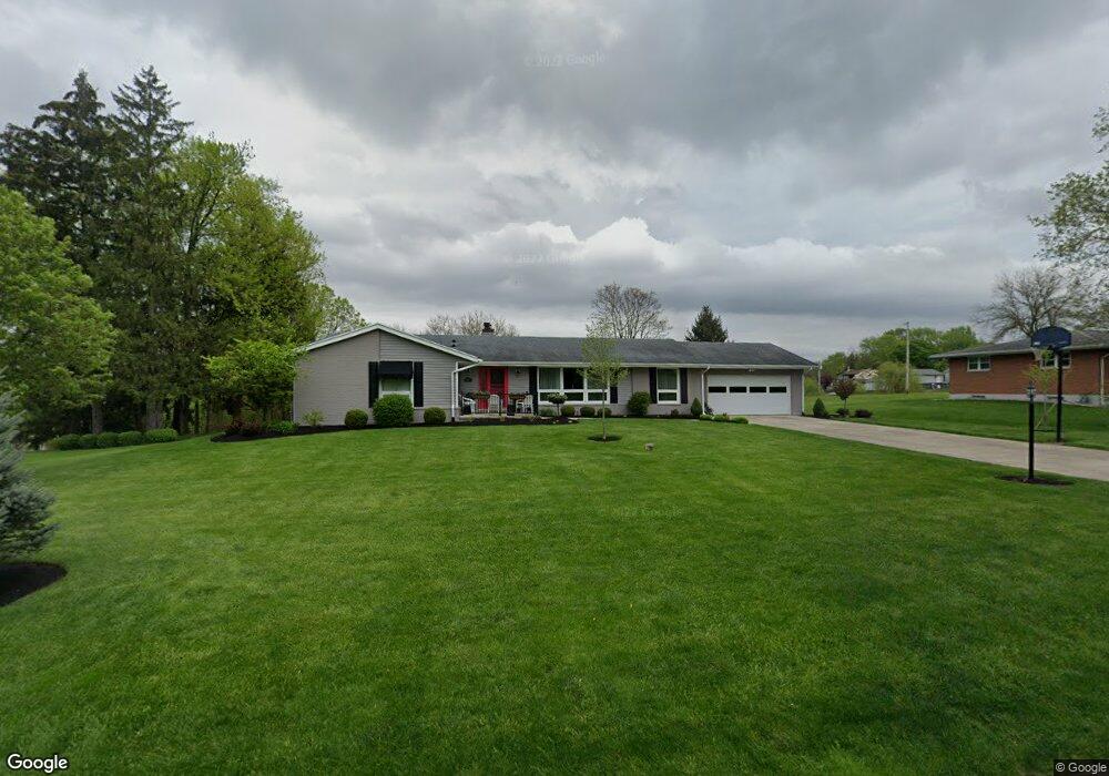
This home is located at 2625 Brookview Rd, Troy, OH 45373 and is currently estimated at $304,944, approximately $169 per square foot. 2625 Brookview Rd is a home located in Miami County with nearby schools including Kyle Elementary School, Van Cleve Elementary School, and Troy Junior High School.
Ownership History
Date
Name
Owned For
Owner Type
Purchase Details
Closed on
Mar 10, 2023
Sold by
Goings Bart M and Goings Anne M
Bought by
Goings Bart M and Goings Anne M
Current Estimated Value
Purchase Details
Closed on
May 23, 1995
Sold by
Olivia Mckenna Est
Bought by
Dunlap Bart M Goings and Dunlap Anne M
Create a Home Valuation Report for This Property
The Home Valuation Report is an in-depth analysis detailing your home's value as well as a comparison with similar homes in the area
Home Values in the Area
Average Home Value in this Area
Purchase History
| Date | Buyer | Sale Price | Title Company |
|---|---|---|---|
| Goings Bart M | -- | -- | |
| Dunlap Bart M Goings | $117,000 | -- |
Source: Public Records
Mortgage History
| Date | Status | Borrower | Loan Amount |
|---|---|---|---|
| Closed | Dunlap Bart M Goings | -- |
Source: Public Records
Tax History Compared to Growth
Tax History
| Year | Tax Paid | Tax Assessment Tax Assessment Total Assessment is a certain percentage of the fair market value that is determined by local assessors to be the total taxable value of land and additions on the property. | Land | Improvement |
|---|---|---|---|---|
| 2024 | $3,303 | $73,780 | $15,890 | $57,890 |
| 2023 | $3,303 | $73,780 | $15,890 | $57,890 |
| 2022 | $2,837 | $73,780 | $15,890 | $57,890 |
| 2021 | $2,567 | $61,460 | $13,230 | $48,230 |
| 2020 | $2,569 | $61,460 | $13,230 | $48,230 |
| 2019 | $2,588 | $61,460 | $13,230 | $48,230 |
| 2018 | $2,428 | $54,180 | $10,220 | $43,960 |
| 2017 | $2,447 | $54,180 | $10,220 | $43,960 |
| 2016 | $2,369 | $52,850 | $10,220 | $42,630 |
| 2015 | $2,332 | $49,850 | $9,630 | $40,220 |
| 2014 | $2,332 | $49,850 | $9,630 | $40,220 |
| 2013 | $2,279 | $48,200 | $9,630 | $38,570 |
Source: Public Records
Map
Nearby Homes
- 2765 Silver Maple Ct
- 2065 S Co Road 25a
- 0 Lincolnshire Unit 939331
- 660 Wisteria Dr
- 2215 Merrimont Dr
- 2015 Merrimont Dr
- 650 Swailes Rd
- 1127 Honeydew Dr
- 3805 Cassandra Dr
- 1117 Honeydew Dr
- 768 Stonehenge Dr
- 1550 Creekwood Dr
- 1216 Wind Rock Ct
- Juniper Plan at Summit Landing
- Ashton Plan at Summit Landing
- Ironwood Plan at Summit Landing
- Walnut Plan at Summit Landing
- Spruce Plan at Summit Landing
- Cooper Plan at Summit Landing
- Bradford Plan at Summit Landing
- 2603 Brookview Rd
- 2693 Brookview Rd
- 2581 Brookview Rd
- 81 Boone Dr
- 2610 Brookview Rd
- 2690 Vista Ridge Dr
- 121 Boone Dr
- 2620 Vista Ridge Dr
- 2640 Brookview Rd
- 2580 Vista Ridge Dr
- 2590 Vista Ridge Dr
- 2600 Brookview Rd
- 123 Boone Dr
- 2577 Brookview Rd
- 2570 Vista Ridge Dr
- 2586 Brookview Rd
- 141 Boone Dr
- 94 Boone Dr
- 2605 Vista Ridge Dr
- 76 Boone Dr