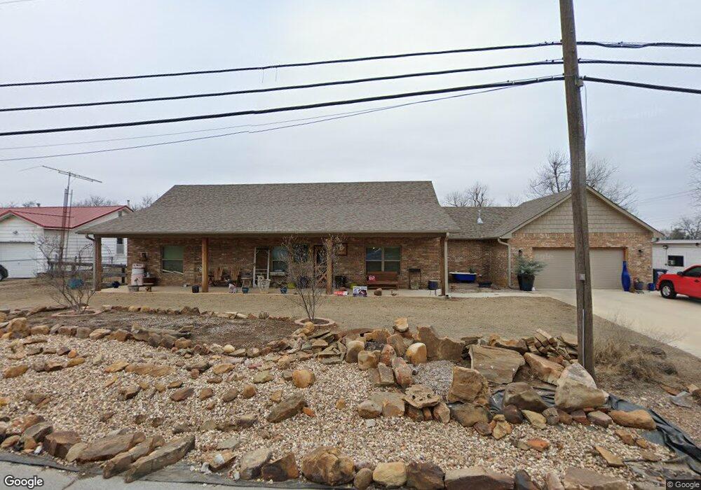
2626 N Beard St Shawnee, OK 74804
Estimated Value: $216,000 - $272,163
3
Beds
2
Baths
1,904
Sq Ft
$126/Sq Ft
Est. Value
About This Home
This home is located at 2626 N Beard St, Shawnee, OK 74804 and is currently estimated at $240,291, approximately $126 per square foot. 2626 N Beard St is a home located in Pottawatomie County with nearby schools including Will Rogers Elementary School, Shawnee Middle School, and Shawnee High School.
Ownership History
Date
Name
Owned For
Owner Type
Purchase Details
Closed on
Sep 15, 2017
Sold by
Beck Daniel G and Beck Elsie N
Bought by
Bryce Dorcie A and Bryce Nancy K
Current Estimated Value
Home Financials for this Owner
Home Financials are based on the most recent Mortgage that was taken out on this home.
Original Mortgage
$29,316
Interest Rate
3.93%
Mortgage Type
Unknown
Purchase Details
Closed on
Jul 5, 2007
Sold by
Beck Daniel G and Beck Elsie N
Bought by
Beck Daniel G and Beck Elsie N
Create a Home Valuation Report for This Property
The Home Valuation Report is an in-depth analysis detailing your home's value as well as a comparison with similar homes in the area
Home Values in the Area
Average Home Value in this Area
Purchase History
| Date | Buyer | Sale Price | Title Company |
|---|---|---|---|
| Bryce Dorcie A | $28,000 | First American Title | |
| Beck Daniel G | -- | None Available |
Source: Public Records
Mortgage History
| Date | Status | Borrower | Loan Amount |
|---|---|---|---|
| Closed | Bryce Dorcie A | $29,316 |
Source: Public Records
Tax History Compared to Growth
Tax History
| Year | Tax Paid | Tax Assessment Tax Assessment Total Assessment is a certain percentage of the fair market value that is determined by local assessors to be the total taxable value of land and additions on the property. | Land | Improvement |
|---|---|---|---|---|
| 2024 | $2,623 | $26,890 | $1,282 | $25,608 |
| 2023 | $2,623 | $26,107 | $2,700 | $23,407 |
| 2022 | $2,576 | $26,107 | $2,700 | $23,407 |
| 2021 | $2,530 | $26,107 | $2,700 | $23,407 |
| 2020 | $2,560 | $26,341 | $2,700 | $23,641 |
| 2019 | $2,630 | $26,193 | $2,700 | $23,493 |
| 2018 | $276 | $2,700 | $2,700 | $0 |
| 2017 | $366 | $3,629 | $1,578 | $2,051 |
| 2016 | $353 | $3,457 | $1,490 | $1,967 |
| 2015 | $329 | $3,293 | $1,352 | $1,941 |
| 2014 | $314 | $3,135 | $1,282 | $1,853 |
Source: Public Records
Map
Nearby Homes
- 9 E Chicago St
- 202 W Franklin St
- 2021 N Broadway Ave
- 3306 N Oklahoma Ave
- 2415 N Minnesota Cir
- 1925 N Park Ave
- 401 E Federal St
- 2304 N Tucker Ave
- 1901 N Bell Ave
- 1817 N Bell Ave
- 806 E Midland St
- 1816 N Bell Ave
- 1822 N Phil Ave
- 1710 N Park Ave
- 2001 N Mckinley Ave
- 1607 N Beard Ave
- 43138 Rain Rd
- 43147 Rain Rd
- 1602 N Bdwy
- 29 Timber Creek Way
- 2604 N Beard St
- 2617 N Market Ave
- 2615 N Beard Ave
- 2619 N Market Ave
- 2609 N Market Ave
- 101 E Macarthur St
- 125 E Macarthur St
- 16 W Chicago St
- 2609 N Beard St
- 105 W Chicago St
- 2506 N Beard St
- 113 W Chicago St
- 10 W Chicago St
- 115 W Chicago St
- 31 W Chicago St
- 300 W Chicago St
- 123 W Chicago St
- 27 W Chicago St
- 129 W Macarthur St
- 2601 N Market Ave