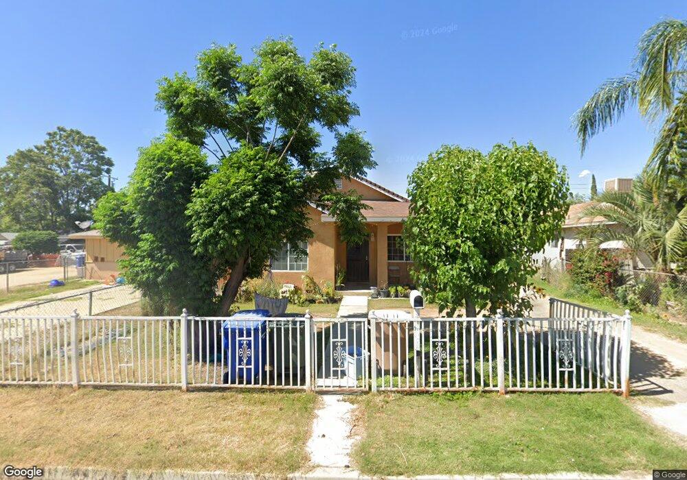
2628 Security Ave Bakersfield, CA 93306
West Pioneer Dr NeighborhoodEstimated Value: $191,000 - $250,091
1
Bed
1
Bath
910
Sq Ft
$257/Sq Ft
Est. Value
About This Home
This home is located at 2628 Security Ave, Bakersfield, CA 93306 and is currently estimated at $234,273, approximately $257 per square foot. 2628 Security Ave is a home located in Kern County with nearby schools including Horace Mann Elementary School, Emerson Middle School, and East Bakersfield High School.
Ownership History
Date
Name
Owned For
Owner Type
Purchase Details
Closed on
Oct 3, 2013
Sold by
Abramovitz Kalman
Bought by
Abramovitz Kalman and Abramovitz Maria I
Current Estimated Value
Purchase Details
Closed on
Oct 4, 2007
Sold by
Abramovitz Maria Isabel
Bought by
Abramovitz Kalman
Purchase Details
Closed on
Sep 27, 2007
Sold by
Benson James A and Benson Stephen C
Bought by
Abramovitz Kalman
Create a Home Valuation Report for This Property
The Home Valuation Report is an in-depth analysis detailing your home's value as well as a comparison with similar homes in the area
Home Values in the Area
Average Home Value in this Area
Purchase History
We collect this data history from publicly available records. To have your information removed, we recommend requesting removal directly through your county’s website.
| Date | Buyer | Sale Price | Title Company |
|---|---|---|---|
| Abramovitz Kalman | -- | Lsi | |
| Abramovitz Kalman | -- | Chicago Title Company | |
| Abramovitz Kalman | $75,000 | Chicago Title Company |
Source: Public Records
Tax History
| Year | Tax Paid | Tax Assessment Tax Assessment Total Assessment is a certain percentage of the fair market value that is determined by local assessors to be the total taxable value of land and additions on the property. | Land | Improvement |
|---|---|---|---|---|
| 2025 | $3,357 | $209,492 | $78,802 | $130,690 |
| 2024 | $3,272 | $205,385 | $77,257 | $128,128 |
| 2023 | $3,272 | $201,359 | $75,743 | $125,616 |
| 2022 | $2,662 | $155,000 | $39,000 | $116,000 |
| 2021 | $2,378 | $137,000 | $34,000 | $103,000 |
| 2020 | $2,176 | $122,000 | $31,000 | $91,000 |
| 2019 | $1,667 | $83,000 | $23,000 | $60,000 |
| 2018 | $1,390 | $62,000 | $16,000 | $46,000 |
| 2017 | $1,643 | $83,000 | $21,000 | $62,000 |
| 2016 | $1,278 | $68,000 | $17,000 | $51,000 |
| 2015 | $1,153 | $56,000 | $14,000 | $42,000 |
| 2014 | $1,115 | $54,000 | $14,000 | $40,000 |
Source: Public Records
Map
Nearby Homes
- 2639 Center St
- 2417 Kentucky St
- 2711 Trust Ave
- 2728 Kentucky St
- 2641 Niles St
- 2717 Monterey St
- 1027 Pentz St
- 2512 Niles St
- 0 Niles St
- 2212 Lake St
- 2208 Lake St
- 2525 Avenida Escuela
- 2229 Lucky St
- 2915 Edison Hwy
- 2235 Pacific Dr
- 2225 Quincy Dr
- 2712 Primera Vista
- 2107 Oregon St
- 0 Hayslett Ave
- 3101 Pioneer Dr
- 2630 Security Ave
- 2626 Security Ave
- 2632 Security Ave
- 2627 Center St
- 2625 Center St
- 2634 Security Ave
- 2629 Center St
- 2618 Security Ave
- 2543 Center St
- 2631 Center St
- 2629 Security Ave
- 2627 Security Ave
- 2636 Security Ave
- 2612 Security Ave
- 2631 Security Ave
- 2541 Center St
- 2633 Center St
- 2623 Security Ave
- 2633 Security Ave
- 2537 Center St
Your Personal Tour Guide
Ask me questions while you tour the home.