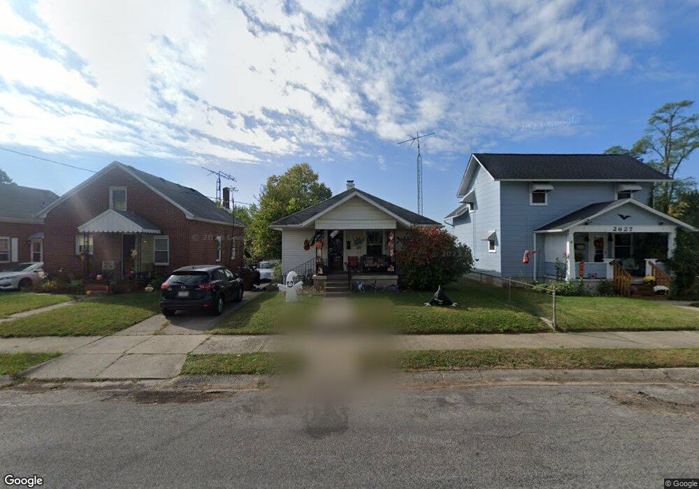
2629 Merritt St Springfield, OH 45503
Estimated Value: $89,000 - $126,000
2
Beds
1
Bath
720
Sq Ft
$146/Sq Ft
Est. Value
About This Home
This home is located at 2629 Merritt St, Springfield, OH 45503 and is currently estimated at $105,033, approximately $145 per square foot. 2629 Merritt St is a home located in Clark County with nearby schools including Kenton Elementary School, Schaefer Middle School, and Springfield High School.
Ownership History
Date
Name
Owned For
Owner Type
Purchase Details
Closed on
Jan 17, 2001
Sold by
Palmer Robert and Palmer Robert D
Bought by
Langen Artha M
Current Estimated Value
Home Financials for this Owner
Home Financials are based on the most recent Mortgage that was taken out on this home.
Original Mortgage
$49,500
Outstanding Balance
$18,317
Interest Rate
7.58%
Mortgage Type
Purchase Money Mortgage
Estimated Equity
$86,716
Purchase Details
Closed on
May 11, 2000
Sold by
Edward Farmer Carl
Bought by
Palmer Robert
Create a Home Valuation Report for This Property
The Home Valuation Report is an in-depth analysis detailing your home's value as well as a comparison with similar homes in the area
Home Values in the Area
Average Home Value in this Area
Purchase History
| Date | Buyer | Sale Price | Title Company |
|---|---|---|---|
| Langen Artha M | $55,000 | -- | |
| Palmer Robert | $38,500 | -- |
Source: Public Records
Mortgage History
| Date | Status | Borrower | Loan Amount |
|---|---|---|---|
| Open | Langen Artha M | $49,500 |
Source: Public Records
Tax History Compared to Growth
Tax History
| Year | Tax Paid | Tax Assessment Tax Assessment Total Assessment is a certain percentage of the fair market value that is determined by local assessors to be the total taxable value of land and additions on the property. | Land | Improvement |
|---|---|---|---|---|
| 2024 | $780 | $15,790 | $3,420 | $12,370 |
| 2023 | $780 | $15,790 | $3,420 | $12,370 |
| 2022 | $2,818 | $15,790 | $3,420 | $12,370 |
| 2021 | $677 | $12,320 | $2,630 | $9,690 |
| 2020 | $679 | $12,320 | $2,630 | $9,690 |
| 2019 | $663 | $12,010 | $2,630 | $9,380 |
| 2018 | $660 | $11,480 | $2,770 | $8,710 |
| 2017 | $660 | $11,477 | $2,765 | $8,712 |
| 2016 | $661 | $11,477 | $2,765 | $8,712 |
| 2015 | $644 | $10,983 | $2,632 | $8,351 |
| 2014 | $642 | $10,983 | $2,632 | $8,351 |
| 2013 | $635 | $10,983 | $2,632 | $8,351 |
Source: Public Records
Map
Nearby Homes
- 2655 Merritt St
- 2603 Roberts Ave
- 2691 Tecumseh Ave
- 2419 Gladden St
- The Siebert Plan at Magnolia Acres
- 2124 Tavenner Ave
- 2340 E Home Rd
- 1827 N Belmont Ave
- 26-28 N Belmont Ave
- 1710 Mitchell Blvd
- 2224-2226 Columbus Ave
- 2210 Larch St
- 2226 Columbus Ave
- 1639 E Mile Rd
- 2149 Larch St
- 1535 Winding Trail
- 2201 Woodside Ave
- 1782 Edwards Ave
- 2020 Woodside Ave
- 1811 Devon Dr
- 2639 Merritt St
- 2627 Merritt St
- 2643 Merritt St
- 2625 Merritt St
- 2621 Merritt St
- 2632 Hilltop Ave
- 2634 Hilltop Ave
- 2630 Hilltop Ave
- 2637 Merritt St
- 2620 Hilltop Ave
- 2620 Hilltop Ave
- 2617 Merritt St
- 2628 Merritt St
- 2636 Merritt St
- 2624 Merritt St
- 2638 Merritt St
- 2636 Hilltop Ave
- 2618 Merritt St
- 2642 Merritt St
- 2659 Merritt St