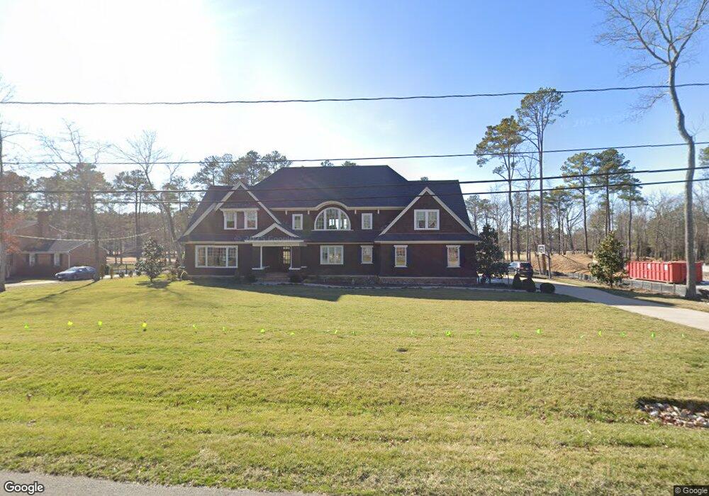
2630 Radstock Rd Midlothian, VA 23113
Salisbury NeighborhoodEstimated Value: $1,327,000 - $1,631,028
4
Beds
6
Baths
5,387
Sq Ft
$275/Sq Ft
Est. Value
About This Home
This home is located at 2630 Radstock Rd, Midlothian, VA 23113 and is currently estimated at $1,480,009, approximately $274 per square foot. 2630 Radstock Rd is a home located in Chesterfield County with nearby schools including Bettie Weaver Elementary School, Midlothian Middle School, and Midlothian High School.
Ownership History
Date
Name
Owned For
Owner Type
Purchase Details
Closed on
Feb 9, 2018
Sold by
Lado Bryon S and Lado Margaret Hayes
Bought by
Ladd Byron S and Ladd Margaret Hayes
Current Estimated Value
Home Financials for this Owner
Home Financials are based on the most recent Mortgage that was taken out on this home.
Original Mortgage
$1,228,000
Outstanding Balance
$1,041,307
Interest Rate
4.04%
Mortgage Type
New Conventional
Estimated Equity
$438,702
Purchase Details
Closed on
Aug 23, 2017
Sold by
O'Neal Michael D
Bought by
Ladd Byron S and Hayes Margaret M
Home Financials for this Owner
Home Financials are based on the most recent Mortgage that was taken out on this home.
Original Mortgage
$161,000
Interest Rate
4.03%
Mortgage Type
Commercial
Create a Home Valuation Report for This Property
The Home Valuation Report is an in-depth analysis detailing your home's value as well as a comparison with similar homes in the area
Home Values in the Area
Average Home Value in this Area
Purchase History
| Date | Buyer | Sale Price | Title Company |
|---|---|---|---|
| Ladd Byron S | -- | None Available | |
| Ladd Byron S | $230,000 | None Available |
Source: Public Records
Mortgage History
| Date | Status | Borrower | Loan Amount |
|---|---|---|---|
| Open | Ladd Byron S | $1,228,000 | |
| Previous Owner | Ladd Byron S | $161,000 |
Source: Public Records
Tax History Compared to Growth
Tax History
| Year | Tax Paid | Tax Assessment Tax Assessment Total Assessment is a certain percentage of the fair market value that is determined by local assessors to be the total taxable value of land and additions on the property. | Land | Improvement |
|---|---|---|---|---|
| 2025 | $11,858 | $1,329,500 | $210,000 | $1,119,500 |
| 2024 | $11,858 | $1,262,100 | $177,000 | $1,085,100 |
| 2023 | $9,108 | $1,000,900 | $86,000 | $914,900 |
| 2022 | $8,918 | $969,400 | $86,000 | $883,400 |
| 2021 | $8,580 | $896,200 | $85,000 | $811,200 |
| 2020 | $8,159 | $858,800 | $85,000 | $773,800 |
| 2019 | $7,648 | $855,200 | $85,000 | $770,200 |
| 2018 | $808 | $85,000 | $85,000 | $0 |
| 2017 | $816 | $85,000 | $85,000 | $0 |
| 2016 | $816 | $85,000 | $85,000 | $0 |
| 2015 | $816 | $85,000 | $85,000 | $0 |
| 2014 | $816 | $85,000 | $85,000 | $0 |
Source: Public Records
Map
Nearby Homes
- 13449 Glendower Rd
- 2725 Stonegate Ct
- 2735 Swanhurst Dr
- 12931 River Hills Dr
- 12602 Foxstone Ct
- 2303 Bream Dr
- 2360 Castlebridge Rd
- 2540 Kentford Rd
- 3020 Mount Hill Dr
- 3437 Kendal Crossing Terrace
- 13637 Langford Dr
- 3107 Handley Rd
- 3010 Middlewood Rd
- 12213 Capwell Dr
- 13901 Dunkeld Terrace
- 13327 Ellerton Terrace
- 1709 Headwaters Rd
- 14100 Worchester Ct
- 3231 Queens Grant Dr
- 11911 Kilrenny Rd
- 2620 Radstock Rd
- 2640 Radstock Rd
- 2635 Radstock Rd
- 2625 Radstock Rd
- 2650 Radstock Rd
- 2615 Radstock Rd
- 13339 Olde Stonegate Rd
- 2600 Radstock Rd
- 2651 Radstock Rd
- 2601 Radstock Rd
- 2640 Salisbury Rd
- 2630 Salisbury Rd
- 2550 Radstock Rd
- 2650 Salisbury Rd
- 13341 Olde Stonegate Rd
- 2551 Radstock Rd
- 2620 Salisbury Rd
- 13320 Olde Stonegate Rd
- 13330 Olde Stonegate Rd
- 13310 Olde Stonegate Rd