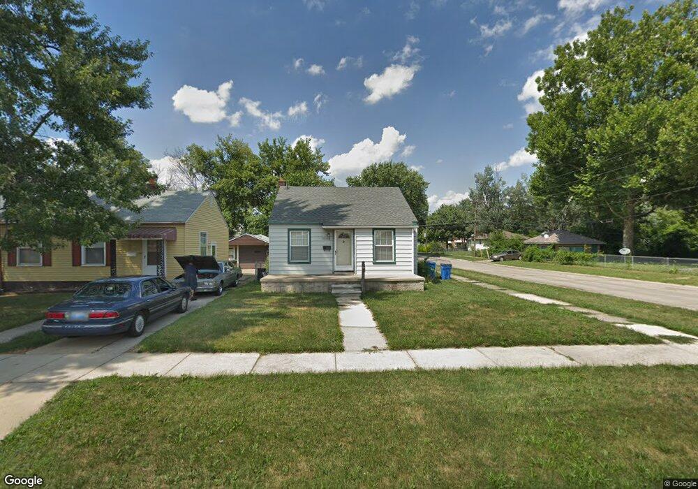
26308 Powers Ave Dearborn Heights, MI 48125
Estimated Value: $127,000 - $148,000
2
Beds
1
Bath
729
Sq Ft
$183/Sq Ft
Est. Value
About This Home
This home is located at 26308 Powers Ave, Dearborn Heights, MI 48125 and is currently estimated at $133,675, approximately $183 per square foot. 26308 Powers Ave is a home located in Wayne County with nearby schools including Quest Charter Academy, West Village Academy, and Peterson-Warren Academy.
Ownership History
Date
Name
Owned For
Owner Type
Purchase Details
Closed on
Aug 1, 2009
Sold by
Slovik Andrew
Bought by
Beason Lori
Current Estimated Value
Purchase Details
Closed on
Oct 11, 2005
Sold by
Perry Ross
Bought by
Jackson Walter
Purchase Details
Closed on
Nov 4, 2003
Sold by
Wojtowicz Raymond J
Bought by
Jackson Wayne
Purchase Details
Closed on
Nov 22, 2000
Sold by
Hardy Gina
Bought by
Perry Ross A
Purchase Details
Closed on
May 13, 1996
Sold by
Sopko Tracy J and Sopko Michael
Bought by
O'Donnellm Douglas J and Tck Mildred
Create a Home Valuation Report for This Property
The Home Valuation Report is an in-depth analysis detailing your home's value as well as a comparison with similar homes in the area
Home Values in the Area
Average Home Value in this Area
Purchase History
| Date | Buyer | Sale Price | Title Company |
|---|---|---|---|
| Beason Lori | -- | None Available | |
| Jackson Walter | -- | Great Lakes Title Of Mi | |
| Jackson Wayne | $72,000 | -- | |
| Perry Ross A | $84,750 | -- | |
| O'Donnellm Douglas J | $52,900 | -- |
Source: Public Records
Tax History Compared to Growth
Tax History
| Year | Tax Paid | Tax Assessment Tax Assessment Total Assessment is a certain percentage of the fair market value that is determined by local assessors to be the total taxable value of land and additions on the property. | Land | Improvement |
|---|---|---|---|---|
| 2025 | $1,269 | $61,500 | $0 | $0 |
| 2024 | $1,269 | $50,700 | $0 | $0 |
| 2023 | $1,153 | $43,500 | $0 | $0 |
| 2022 | $1,697 | $36,700 | $0 | $0 |
| 2021 | $1,683 | $32,400 | $0 | $0 |
| 2019 | $1,558 | $25,500 | $0 | $0 |
| 2018 | $1,000 | $24,200 | $0 | $0 |
| 2017 | $1,031 | $23,600 | $0 | $0 |
| 2016 | $1,921 | $23,900 | $0 | $0 |
| 2015 | $2,220 | $22,200 | $0 | $0 |
| 2013 | $2,390 | $25,000 | $0 | $0 |
| 2010 | -- | $28,700 | $0 | $0 |
Source: Public Records
Map
Nearby Homes
- 26532 Powers Ave
- 26225 McDonald St
- 4863 Glenis St
- 26106 Powers Ave
- 26439 Hopkins St
- 26458 Hopkins St
- 25965 Currier St
- 25895 Annapolis St
- 26159 Stanford St
- 5526 Sylvia St
- 5970 John Daly St
- 4110 John Daly St
- 5993 John Daly St
- 25628 Powers Ave
- 26202 Colgate St
- 26773 Colgate St
- 26231 Andover St
- 5961 Marvin St
- 5845 Beech Daly Rd
- 6075 Duncan St
- 26316 Powers Ave
- 26309 Pennie St
- 26317 Pennie St
- 26324 Powers Ave
- 26325 Pennie St
- 26332 Powers Ave
- 26333 Pennie St
- 26286 Powers Ave
- 26295 Pennie St
- 26340 Powers Ave
- 26341 Pennie St
- 26276 Powers Ave
- 26275 Pennie St
- 26348 Powers Ave
- 26349 Pennie St
- 26266 Powers Ave
- 26265 Pennie St
- 26356 Powers Ave
- 26357 Pennie St
- 26308 Pennie St