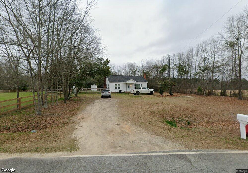
2633 Quail Farm Rd Thomson, GA 30824
Estimated Value: $163,000 - $388,000
2
Beds
1
Bath
1,536
Sq Ft
$163/Sq Ft
Est. Value
About This Home
This home is located at 2633 Quail Farm Rd, Thomson, GA 30824 and is currently estimated at $250,770, approximately $163 per square foot. 2633 Quail Farm Rd is a home with nearby schools including Thomson High School.
Ownership History
Date
Name
Owned For
Owner Type
Purchase Details
Closed on
Feb 26, 2021
Sold by
Cortes Alexis Geovanni Gonzal
Bought by
Cortez & Co Llc
Current Estimated Value
Purchase Details
Closed on
Mar 9, 2020
Sold by
Reyes Jessica Erin
Bought by
Reyes Kevin Gerardo
Purchase Details
Closed on
Mar 5, 2013
Sold by
Talkington Tammy R
Bought by
Talkington Tammy R and Talkington Jessica Erin
Purchase Details
Closed on
Jan 31, 1994
Bought by
Talkington Deborah
Create a Home Valuation Report for This Property
The Home Valuation Report is an in-depth analysis detailing your home's value as well as a comparison with similar homes in the area
Home Values in the Area
Average Home Value in this Area
Purchase History
| Date | Buyer | Sale Price | Title Company |
|---|---|---|---|
| Cortez & Co Llc | -- | -- | |
| Reyes Kevin Gerardo | -- | -- | |
| Talkington Tammy R | -- | -- | |
| Talkington Deborah | -- | -- |
Source: Public Records
Tax History Compared to Growth
Tax History
| Year | Tax Paid | Tax Assessment Tax Assessment Total Assessment is a certain percentage of the fair market value that is determined by local assessors to be the total taxable value of land and additions on the property. | Land | Improvement |
|---|---|---|---|---|
| 2025 | $1,253 | $51,016 | $3,458 | $47,558 |
| 2024 | $1,253 | $48,324 | $3,116 | $45,208 |
| 2023 | $1,207 | $46,499 | $3,116 | $43,383 |
| 2022 | $451 | $14,486 | $3,116 | $11,370 |
| 2021 | $397 | $13,073 | $4,033 | $9,040 |
| 2020 | $259 | $9,183 | $3,212 | $5,971 |
| 2019 | $262 | $9,183 | $3,212 | $5,971 |
| 2018 | $188 | $6,598 | $3,212 | $3,386 |
| 2017 | $181 | $6,598 | $3,212 | $3,386 |
| 2016 | $170 | $6,190 | $3,212 | $2,978 |
| 2015 | $415 | $16,579 | $5,256 | $11,324 |
| 2014 | $416 | $16,580 | $5,256 | $11,324 |
| 2013 | -- | $16,580 | $5,256 | $11,323 |
Source: Public Records
Map
Nearby Homes
- 789 George McDuffie Rd
- 1543 Wrens Hwy
- 000 Wrens Hwy
- 0 Mitchner Rd Unit 548843
- 0 Wrens Hwy Unit 10652460
- 0 Wrens Hwy Unit 549833
- 1008 Wrens Hwy
- 1761 Augusta Hwy
- 2522 Ellington Airline Rd
- 354 King St
- 118 Langham St
- 67 Shadowmoor Cir
- 1463 Lokey Dr
- 415 Stonewall Dr
- 306 Michael St
- 709 Pine Lane Dr
- 1280 Acadia Dr
- 1009 Berkley Ct
- 1085 Berkley Ct
- 1037 Berkley Ct
- 2656 Quail Farm Rd
- 2602 Quail Farm Rd
- 2682 Quail Farm Rd
- 2700 Quail Farm Rd
- 2723 Quail Farm Rd
- 2669 Wrens Hwy
- 2545 Quail Farm Rd
- 2529 Quail Farm Rd
- 2819 Wrens Hwy
- 115 May Rd
- 2686 Wrens Hwy
- 2708 Wrens Hwy
- 121 May Rd
- 2724 Wrens Hwy
- 2790 Wrens Hwy
- 2818 Wrens Hwy
- 2828 Wrens Hwy
- 140 May Rd
- 2720 Quail Farm Rd
- 2421 Anderson Rd