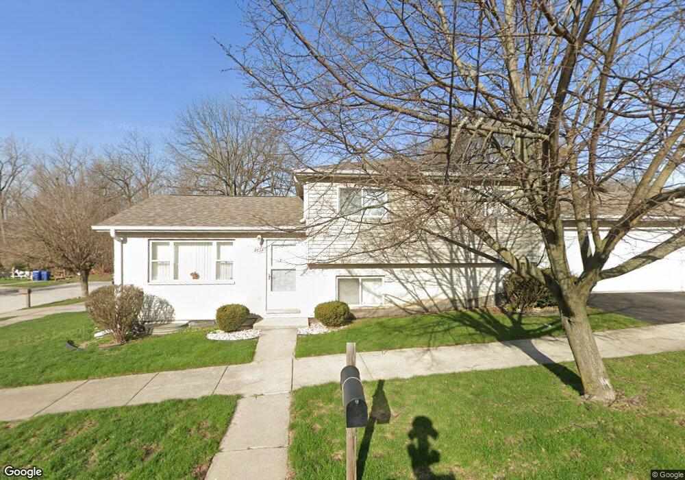
2634 Grove St Blue Island, IL 60406
Estimated Value: $203,000 - $280,000
3
Beds
2
Baths
1,056
Sq Ft
$229/Sq Ft
Est. Value
About This Home
This home is located at 2634 Grove St, Blue Island, IL 60406 and is currently estimated at $241,590, approximately $228 per square foot. 2634 Grove St is a home located in Cook County with nearby schools including Whittier Elementary School, Lincoln Elementary School, and Everett F Kerr Middle School.
Ownership History
Date
Name
Owned For
Owner Type
Purchase Details
Closed on
Jul 2, 2016
Sold by
Fisher Michael E and Fisher Kathleen Brown
Bought by
Fisher Michael E and Fisher Kathleen Brown
Current Estimated Value
Purchase Details
Closed on
Jun 24, 2000
Sold by
Fisher Michael E
Bought by
Fisher Michael E and Fisher Kathleen Brown
Purchase Details
Closed on
Oct 17, 1997
Sold by
Oxford Bank & Trust
Bought by
Fisher Michael E
Home Financials for this Owner
Home Financials are based on the most recent Mortgage that was taken out on this home.
Original Mortgage
$133,800
Outstanding Balance
$21,874
Interest Rate
7.65%
Estimated Equity
$219,716
Create a Home Valuation Report for This Property
The Home Valuation Report is an in-depth analysis detailing your home's value as well as a comparison with similar homes in the area
Home Values in the Area
Average Home Value in this Area
Purchase History
| Date | Buyer | Sale Price | Title Company |
|---|---|---|---|
| Fisher Michael E | -- | None Available | |
| Fisher Michael E | -- | -- | |
| Fisher Michael E | $94,000 | -- |
Source: Public Records
Mortgage History
| Date | Status | Borrower | Loan Amount |
|---|---|---|---|
| Open | Fisher Michael E | $133,800 |
Source: Public Records
Tax History Compared to Growth
Tax History
| Year | Tax Paid | Tax Assessment Tax Assessment Total Assessment is a certain percentage of the fair market value that is determined by local assessors to be the total taxable value of land and additions on the property. | Land | Improvement |
|---|---|---|---|---|
| 2024 | $7,018 | $23,000 | $1,858 | $21,142 |
| 2023 | $5,470 | $23,000 | $1,858 | $21,142 |
| 2022 | $5,470 | $16,587 | $1,625 | $14,962 |
| 2021 | $5,220 | $16,587 | $1,625 | $14,962 |
| 2020 | $4,140 | $16,587 | $1,625 | $14,962 |
| 2019 | $3,082 | $19,804 | $1,509 | $18,295 |
| 2018 | $2,951 | $19,804 | $1,509 | $18,295 |
| 2017 | $2,936 | $19,804 | $1,509 | $18,295 |
| 2016 | $4,227 | $16,940 | $1,277 | $15,663 |
| 2015 | $4,321 | $16,940 | $1,277 | $15,663 |
| 2014 | $4,630 | $16,940 | $1,277 | $15,663 |
| 2013 | $4,397 | $16,133 | $1,277 | $14,856 |
Source: Public Records
Map
Nearby Homes
- 2638 Vermont St
- 2620 Vermont St
- 2445 High St
- 2853 Everett St
- 2824 Union St
- 2823 Broadway St
- 2745 Desplaines St
- 13134 Sacramento Ave
- 13430 Ann St
- 2728 135th St
- 2336 Union St Unit 5
- 2336 Union St Unit 3
- 2336 Union St Unit 4
- 2335 Walnut St
- 13346 Irving Ave
- 12609 Maple Ave
- 12552 Highland Ave
- 12558 Fairview Ave Unit 1B
- 12602 Artesian Ave
- 12548 Fairview Ave Unit BLDG1