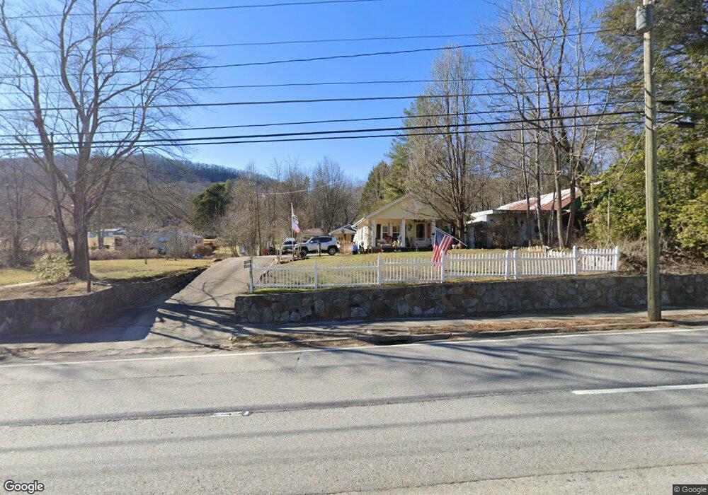
2637 Highway 441 N Clayton, GA 30525
Estimated Value: $168,000 - $303,000
3
Beds
1
Bath
1,248
Sq Ft
$198/Sq Ft
Est. Value
About This Home
This home is located at 2637 Highway 441 N, Clayton, GA 30525 and is currently estimated at $246,648, approximately $197 per square foot. 2637 Highway 441 N is a home with nearby schools including Rabun County Primary School, Rabun County High School, and Rabun Gap Nacoochee School.
Ownership History
Date
Name
Owned For
Owner Type
Purchase Details
Closed on
Mar 5, 2014
Sold by
Donalson Marilyn C
Bought by
Walker Bobby E
Current Estimated Value
Purchase Details
Closed on
Sep 27, 2011
Sold by
Donalson Brant Suc
Bought by
Donalson Marilyn C
Purchase Details
Closed on
Aug 16, 2011
Sold by
Donalson Brant Suc
Bought by
Donalson Marilyn C
Purchase Details
Closed on
Nov 1, 2006
Sold by
Not Provided
Bought by
Donalson Brant
Purchase Details
Closed on
Oct 1, 2003
Purchase Details
Closed on
Aug 1, 2002
Purchase Details
Closed on
Jun 1, 1998
Purchase Details
Closed on
Jul 1, 1977
Create a Home Valuation Report for This Property
The Home Valuation Report is an in-depth analysis detailing your home's value as well as a comparison with similar homes in the area
Home Values in the Area
Average Home Value in this Area
Purchase History
| Date | Buyer | Sale Price | Title Company |
|---|---|---|---|
| Walker Bobby E | $95,000 | -- | |
| Walker Bobby E | $95,000 | -- | |
| Donalson Marilyn C | -- | -- | |
| Donalson Marilyn C | -- | -- | |
| Donalson Marilyn C | -- | -- | |
| Donalson Brant | $123,500 | -- | |
| Donalson Brant | $123,500 | -- | |
| -- | -- | -- | |
| -- | -- | -- | |
| -- | $125,000 | -- | |
| -- | $125,000 | -- | |
| -- | $85,500 | -- | |
| -- | $85,500 | -- | |
| -- | $17,000 | -- | |
| -- | $17,000 | -- |
Source: Public Records
Tax History Compared to Growth
Tax History
| Year | Tax Paid | Tax Assessment Tax Assessment Total Assessment is a certain percentage of the fair market value that is determined by local assessors to be the total taxable value of land and additions on the property. | Land | Improvement |
|---|---|---|---|---|
| 2025 | $876 | $54,585 | $6,250 | $48,335 |
| 2024 | $830 | $51,696 | $6,250 | $45,446 |
| 2023 | $844 | $46,087 | $6,250 | $39,837 |
| 2022 | $818 | $44,691 | $6,250 | $38,441 |
| 2021 | $747 | $39,827 | $6,250 | $33,577 |
| 2020 | $701 | $36,145 | $6,250 | $29,895 |
| 2019 | $706 | $36,145 | $6,250 | $29,895 |
| 2018 | $709 | $36,145 | $6,250 | $29,895 |
Source: Public Records
Map
Nearby Homes
- 11 Electric Ave
- 37 Erwin St
- 55 Wallace St
- 0 Green St Unit 10565711
- 1 Electric Ave
- 36 Maple Springs Ln
- 548 Black Rock Mountain Pkwy
- 173 Blacks Creek Dr
- 0 Forest Canopy Way Unit 11
- 527 Abby Ln
- 0 Black Rock Estates Unit 25 10374676
- 331 Black Bear Den Rd
- 620 Falling Creek Trail
- 1327 Pinnacle Dr
- 52 Lucky Ln
- 1387 Valley St
- 1806 Pinnacle Dr
- 153 Coleman Heights Ln
- 700 Prime Hill Dr
- 0 Crest Ln Unit LOT 5 10572844
- 2669 Highway 441 N
- 2637 Highway 441 N
- 42 S Johnson Ave
- 20 Green St
- 18 S Johnson Ave
- 2595 Highway 441 N
- 2666 Highway 441
- 2595 Highway 441
- 2595 U S 441
- TRACT 3 W Langston St
- TRACT 1 W Langston St
- 51 S Johnson Ave
- 2596 U S 441
- 2596 Highway 441
- 84 Green St
- W W Langston Ave
- 73 Johnson
- S N Johnson St
- 2568 Highway 441 N
- 124 Hunnicutt Dr