


2638 SW Mt Baker St McMinnville, OR 97128
Estimated payment $3,707/month
Highlights
- Craftsman Architecture
- Territorial View
- Wood Flooring
- Duniway Middle School Rated A
- Vaulted Ceiling
- Bonus Room
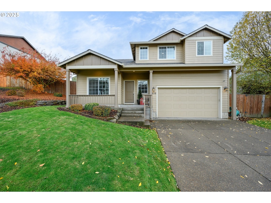
About This Home
Beautifully maintained one-owner Craftsman located in one of McMinnville’s most desirable neighborhoods, just steps from West Hills Neighborhood Park. Built by Black Diamond Homes, this property offers an especially flexible floor plan. Use it as 3 bedrooms plus a bonus room and office, or configure up to 5 full bedrooms, all with closets. The kitchen and dining area open to the family room, creating a warm and welcoming gathering space. A patio off the dining area provides easy access to the fenced backyard for outdoor enjoyment. Additional features include high ceilings and a spacious laundry room with a sink and ample storage. Classic details and thoughtful design provide both warmth and versatility throughout this lovely home!
Listing Agent
Bella Casa Real Estate Group Brokerage Phone: 503-435-8251 License #200405258 Listed on: 11/17/2025
Home Details
Home Type
- Single Family
Est. Annual Taxes
- $6,145
Year Built
- Built in 2013
Lot Details
- 7,405 Sq Ft Lot
- Fenced
- Level Lot
- Private Yard
Parking
- 2 Car Attached Garage
- Garage Door Opener
- Driveway
- On-Street Parking
Home Design
- Craftsman Architecture
- Composition Roof
- Cement Siding
- Concrete Perimeter Foundation
Interior Spaces
- 2,249 Sq Ft Home
- 2-Story Property
- Built-In Features
- Vaulted Ceiling
- Gas Fireplace
- Double Pane Windows
- Vinyl Clad Windows
- Family Room
- Living Room
- Dining Room
- Bonus Room
- Territorial Views
- Crawl Space
- Laundry Room
Kitchen
- Microwave
- Dishwasher
- Granite Countertops
- Disposal
Flooring
- Wood
- Wall to Wall Carpet
- Vinyl
Bedrooms and Bathrooms
- 4 Bedrooms
- Walk-in Shower
Accessible Home Design
- Accessibility Features
Outdoor Features
- Patio
- Shed
- Porch
Schools
- Willamette Elementary School
- Duniway Middle School
- Mcminnville High School
Utilities
- Forced Air Heating and Cooling System
- Heating System Uses Gas
Community Details
- No Home Owners Association
Listing and Financial Details
- Assessor Parcel Number 535486
Map
Home Values in the Area
Average Home Value in this Area
Tax History
| Year | Tax Paid | Tax Assessment Tax Assessment Total Assessment is a certain percentage of the fair market value that is determined by local assessors to be the total taxable value of land and additions on the property. | Land | Improvement |
|---|---|---|---|---|
| 2025 | $6,145 | $345,086 | -- | -- |
| 2024 | $5,823 | $335,035 | -- | -- |
| 2023 | $5,498 | $325,277 | $0 | $0 |
| 2022 | $5,208 | $315,803 | $0 | $0 |
| 2021 | $5,085 | $306,605 | $0 | $0 |
| 2020 | $5,045 | $297,675 | $0 | $0 |
| 2019 | $4,908 | $289,005 | $0 | $0 |
| 2018 | $4,811 | $280,587 | $0 | $0 |
| 2017 | $4,643 | $272,415 | $0 | $0 |
| 2016 | $4,477 | $264,481 | $0 | $0 |
| 2015 | $4,368 | $256,779 | $0 | $0 |
| 2014 | $4,132 | $249,302 | $0 | $0 |
Property History
| Date | Event | Price | List to Sale | Price per Sq Ft |
|---|---|---|---|---|
| 11/25/2025 11/25/25 | Pending | -- | -- | -- |
| 11/17/2025 11/17/25 | For Sale | $604,900 | -- | $269 / Sq Ft |
Purchase History
| Date | Type | Sale Price | Title Company |
|---|---|---|---|
| Warranty Deed | $280,600 | First American Title | |
| Warranty Deed | $59,900 | First American Title |
Mortgage History
| Date | Status | Loan Amount | Loan Type |
|---|---|---|---|
| Open | $266,570 | New Conventional |
Source: Regional Multiple Listing Service (RMLS)
MLS Number: 225304064
APN: 535486
Disclaimer: Certain information contained herein is derived from information provided by parties other than Homes.com. All information provided is deemed reliable, but is not guaranteed to be accurate and should be independently verified.
![]() The content relating to real estate for sale on this web site comes in part from the IDX program of the RMLS™ of Portland, Oregon. Real estate listings held by brokerage firms other than Ten-X are marked with the RMLS™ logo, and detailed information about these properties includes the names of the listing brokers. Listing content is copyright © 2025 RMLS™, Portland, Oregon. Some properties which appear for sale on this web site may subsequently have sold or may no longer be available. All information provided is deemed reliable but is not guaranteed and should be independently verified.
The content relating to real estate for sale on this web site comes in part from the IDX program of the RMLS™ of Portland, Oregon. Real estate listings held by brokerage firms other than Ten-X are marked with the RMLS™ logo, and detailed information about these properties includes the names of the listing brokers. Listing content is copyright © 2025 RMLS™, Portland, Oregon. Some properties which appear for sale on this web site may subsequently have sold or may no longer be available. All information provided is deemed reliable but is not guaranteed and should be independently verified.
- 2650 NW Mt Ashland Dr
- 177 SW Mt Mazama St
- 295 SW Mount Saint Helens St
- 348 SW Mt Rainier St
- 398 SW Mt Mazama St
- 2683 NW Mt Hood Dr
- 310 SW Mount Adams St
- 361 SW Howard Dr
- 2805 NW Mount Ashland Ln
- 525 NW Hillcrest Loop
- 459 SW Howard Dr
- 2898 NW Mount Ashland Ln
- 2317 SW Peggy St
- 2379 SW Leo St
- 130 SW West Hills Dr
- 117 NW Canyon Creek Dr
- 164 SW Mallard St
- 433 SW Pemberly Loop
- 2690 NW Meadows Dr
- 2598 NW Meadows Dr
