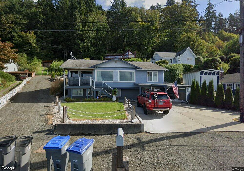
2639 Beach Dr E Port Orchard, WA 98366
Estimated Value: $725,773 - $983,000
3
Beds
3
Baths
2,455
Sq Ft
$341/Sq Ft
Est. Value
About This Home
This home is located at 2639 Beach Dr E, Port Orchard, WA 98366 and is currently estimated at $835,943, approximately $340 per square foot. 2639 Beach Dr E is a home located in Kitsap County with nearby schools including Orchard Heights Elementary School, Marcus Whitman Middle School, and South Kitsap High School.
Ownership History
Date
Name
Owned For
Owner Type
Purchase Details
Closed on
Sep 11, 2002
Sold by
Moore Carroll G and Moore Sharon L
Bought by
Oliver Brian T and Oliver Dorna J
Current Estimated Value
Home Financials for this Owner
Home Financials are based on the most recent Mortgage that was taken out on this home.
Original Mortgage
$252,000
Outstanding Balance
$106,267
Interest Rate
6.37%
Estimated Equity
$729,676
Create a Home Valuation Report for This Property
The Home Valuation Report is an in-depth analysis detailing your home's value as well as a comparison with similar homes in the area
Home Values in the Area
Average Home Value in this Area
Purchase History
| Date | Buyer | Sale Price | Title Company |
|---|---|---|---|
| Oliver Brian T | $315,000 | Transnation Title Insurance |
Source: Public Records
Mortgage History
| Date | Status | Borrower | Loan Amount |
|---|---|---|---|
| Open | Oliver Brian T | $252,000 | |
| Closed | Oliver Brian T | $63,000 |
Source: Public Records
Tax History Compared to Growth
Tax History
| Year | Tax Paid | Tax Assessment Tax Assessment Total Assessment is a certain percentage of the fair market value that is determined by local assessors to be the total taxable value of land and additions on the property. | Land | Improvement |
|---|---|---|---|---|
| 2026 | $6,134 | $713,420 | $159,860 | $553,560 |
| 2025 | $6,134 | $713,420 | $159,860 | $553,560 |
| 2024 | $5,948 | $713,420 | $159,860 | $553,560 |
| 2023 | $5,907 | $713,420 | $159,860 | $553,560 |
| 2022 | $5,663 | $572,130 | $128,130 | $444,000 |
| 2021 | $5,438 | $519,900 | $122,030 | $397,870 |
| 2020 | $5,052 | $468,430 | $87,240 | $381,190 |
| 2019 | $4,333 | $441,920 | $82,270 | $359,650 |
| 2018 | $4,543 | $347,980 | $74,470 | $273,510 |
| 2017 | $3,762 | $347,980 | $74,470 | $273,510 |
| 2016 | $3,910 | $331,510 | $70,920 | $260,590 |
| 2015 | $3,587 | $307,820 | $70,920 | $236,900 |
| 2014 | -- | $332,670 | $78,670 | $254,000 |
| 2013 | -- | $289,940 | $87,960 | $201,980 |
Source: Public Records
Map
Nearby Homes
- 3538 Beach Dr E
- 4898 E Collins Rd
- 3643 Beach Dr E
- 1242 Lidstrom Rd E
- 1200 Baby Doll Rd E
- 1355 Ahlstrom Rd E
- 1863 Connery Ln E
- 5675 E Hillcrest Dr
- 609 Shore Dr
- 5495 E Collins Rd
- 1021 Shore Dr
- 0 Beach Dr E Unit NWM2139946
- 3140 E Washington St
- 0 E Washington St Unit NWM2337936
- 22 Lots E Washington St
- 740 Tufts Ave E
- 1010 Perry Ave Unit 104
- 219 Shore Dr
- 5396 E Blaisdell Ln
- 1315 Trenton Ave
- 2627 Beach Dr E
- 2695 Beach Dr E
- 2621 Beach Dr E
- 2713 Beach Dr E
- 2671 Beach Dr E
- 2599 Beach Dr E
- 2749 Beach Dr E
- 14 Beach Dr E
- 2573 Beach Dr E
- 2547 Beach Dr E
- 2795 Beach Dr E
- 2811 Beach Dr E
- 2521 Beach Dr E
- 2835 Beach Dr E
- 2855 Beach Dr E
- 2500 Beach Dr E
- 2497 Beach Dr E
- 2873 Beach Dr E
- 2485 Beach Dr E
- 2439 Beach Dr E