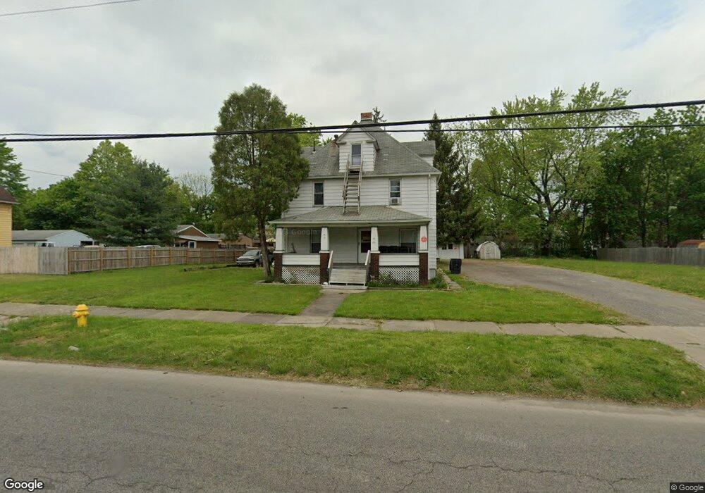
264 Atlantic St NW Warren, OH 44483
North End NeighborhoodEstimated Value: $49,000 - $103,000
3
Beds
2
Baths
2,250
Sq Ft
$33/Sq Ft
Est. Value
About This Home
This home is located at 264 Atlantic St NW, Warren, OH 44483 and is currently estimated at $74,193, approximately $32 per square foot. 264 Atlantic St NW is a home located in Trumbull County with nearby schools including Warren G. Harding High School, Willard PK-8 School, and Steam Academy of Warren.
Ownership History
Date
Name
Owned For
Owner Type
Purchase Details
Closed on
May 8, 2024
Sold by
Sampsons Rental Property Llc
Bought by
Horton Charles
Current Estimated Value
Purchase Details
Closed on
Mar 6, 2023
Sold by
Sampsons Rental Property Llc
Bought by
Sampsons Rental Property Llc
Purchase Details
Closed on
Jan 5, 2008
Sold by
Sampson Sheri and Sampson Gregory
Bought by
Sampsons Rental Property Llc
Purchase Details
Closed on
Dec 9, 2002
Sold by
Sampson Gregory L
Bought by
Sampson Gregory L and Sampson Sheri L
Purchase Details
Closed on
Jan 1, 1990
Bought by
Gregory Gregory L and Gregory S
Create a Home Valuation Report for This Property
The Home Valuation Report is an in-depth analysis detailing your home's value as well as a comparison with similar homes in the area
Home Values in the Area
Average Home Value in this Area
Purchase History
| Date | Buyer | Sale Price | Title Company |
|---|---|---|---|
| Horton Charles | $10,000 | None Listed On Document | |
| Sampsons Rental Property Llc | -- | None Listed On Document | |
| Sampsons Rental Property Llc | -- | Attorney | |
| Sampson Gregory L | -- | -- | |
| Gregory Gregory L | -- | -- |
Source: Public Records
Tax History Compared to Growth
Tax History
| Year | Tax Paid | Tax Assessment Tax Assessment Total Assessment is a certain percentage of the fair market value that is determined by local assessors to be the total taxable value of land and additions on the property. | Land | Improvement |
|---|---|---|---|---|
| 2024 | $438 | $8,650 | $2,100 | $6,550 |
| 2023 | $438 | $8,650 | $2,100 | $6,550 |
| 2022 | $517 | $7,980 | $2,100 | $5,880 |
| 2021 | $518 | $7,980 | $2,100 | $5,880 |
| 2020 | $519 | $7,980 | $2,100 | $5,880 |
| 2019 | $527 | $7,700 | $2,100 | $5,600 |
| 2018 | $525 | $7,700 | $2,100 | $5,600 |
| 2017 | $517 | $7,700 | $2,100 | $5,600 |
| 2016 | $646 | $9,950 | $3,050 | $6,900 |
| 2015 | $641 | $9,950 | $3,050 | $6,900 |
| 2014 | $638 | $9,950 | $3,050 | $6,900 |
| 2013 | $648 | $10,650 | $3,050 | $7,600 |
Source: Public Records
Map
Nearby Homes
- 855 Adams Ave NW
- 632 Mercer Ave NE
- 555 Hall St NW
- 1459 West Ave NW
- 1447 Grove Ave NW
- 1033 Olive Ave NE
- 1524 Vernon Ave NW
- 1530 Vernon Ave NW
- 428 Waverly Ave NE
- 343 Griswold St NE
- 433 Olive Ave NE Unit 435
- 1706 Vernon Ave NW
- 970 Tod Ave NW
- 242 Idylwild St NE
- 753 Packard St NW
- 436 Idylwild
- 783 Packard St NW
- 0 Federal St NW
- 670 Comstock St NW
- 494 Federal St NW
- 276 Atlantic St NW
- 242 Atlantic St NW
- 288 Atlantic St NW
- 249 Forest St NW
- 257 Forest St NW
- 235 Forest St NW
- 228 Atlantic St NW
- 259 Atlantic St NW
- 227 Forest St NW
- 300 Atlantic St NW
- 300 Atlantic St NE
- 269 Atlantic St NW
- 263 Forest St NW
- 220 Atlantic St NW
- 249 Atlantic St NW
- 155 Atlantic St NW
- 237 239 Atlantic St NW
- 279 Forest St NW
- 1066 Depot St NW
- 269 Forest St NW