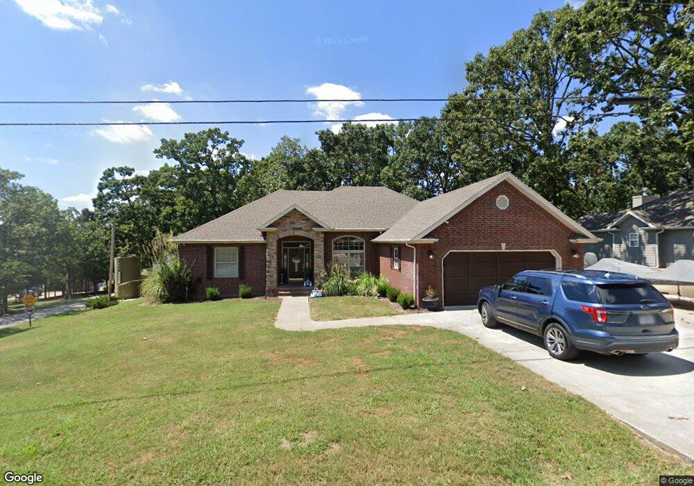
264 Tablerock Cir Branson, MO 65616
Estimated Value: $327,577 - $696,000
Studio
--
Bath
1,921
Sq Ft
$293/Sq Ft
Est. Value
About This Home
This home is located at 264 Tablerock Cir, Branson, MO 65616 and is currently estimated at $562,144, approximately $292 per square foot. 264 Tablerock Cir is a home with nearby schools including Reeds Spring Primary School, Reeds Spring Elementary School, and Reeds Spring Middle School.
Ownership History
Date
Name
Owned For
Owner Type
Purchase Details
Closed on
May 24, 2025
Sold by
Akdeniz Ozgur
Bought by
Bereyso Kelly
Current Estimated Value
Purchase Details
Closed on
Mar 8, 2006
Sold by
Lansdale Terry and Lansdale Marta
Bought by
Barrett Dennis B and Barrett Cynthia
Home Financials for this Owner
Home Financials are based on the most recent Mortgage that was taken out on this home.
Original Mortgage
$203,300
Interest Rate
6.09%
Mortgage Type
New Conventional
Purchase Details
Closed on
Feb 17, 2006
Sold by
Lansdale Terry and Lansdale Marta
Bought by
Stenzel Leroy D and Stenzel Paulette A
Home Financials for this Owner
Home Financials are based on the most recent Mortgage that was taken out on this home.
Original Mortgage
$203,300
Interest Rate
6.09%
Mortgage Type
New Conventional
Create a Home Valuation Report for This Property
The Home Valuation Report is an in-depth analysis detailing your home's value as well as a comparison with similar homes in the area
Home Values in the Area
Average Home Value in this Area
Purchase History
| Date | Buyer | Sale Price | Title Company |
|---|---|---|---|
| Bereyso Kelly | -- | None Listed On Document | |
| Barrett Dennis B | -- | -- | |
| Stenzel Leroy D | -- | -- |
Source: Public Records
Mortgage History
| Date | Status | Borrower | Loan Amount |
|---|---|---|---|
| Previous Owner | Barrett Dennis B | $203,300 | |
| Previous Owner | Stenzel Leroy D | $125,000 |
Source: Public Records
Tax History
| Year | Tax Paid | Tax Assessment Tax Assessment Total Assessment is a certain percentage of the fair market value that is determined by local assessors to be the total taxable value of land and additions on the property. | Land | Improvement |
|---|---|---|---|---|
| 2025 | $1,167 | $23,830 | -- | -- |
| 2024 | $1,166 | $23,830 | -- | -- |
| 2023 | $1,166 | $23,830 | -- | -- |
| 2022 | $1,159 | $23,830 | $0 | $0 |
| 2021 | $1,173 | $23,830 | $0 | $0 |
| 2020 | $1,033 | $23,830 | $0 | $0 |
| 2019 | $1,028 | $23,830 | $0 | $0 |
| 2018 | $1,061 | $23,830 | $0 | $0 |
| 2017 | $1,063 | $24,640 | $0 | $0 |
| 2016 | $1,033 | $24,640 | $0 | $0 |
| 2015 | $1,035 | $24,640 | $0 | $0 |
| 2014 | $1,012 | $24,640 | $0 | $0 |
| 2012 | $1,014 | $24,470 | $0 | $0 |
Source: Public Records
Map
Nearby Homes
- 48 Timber Oaks Trail Unit A
- 52 Timber Oaks Trail Unit B
- 60 Timber Oaks Trail Unit C
- 49 Timber Trace Ln
- 48 Timber Trace Ln
- 70 Dogwood Park Trail Unit 1510
- 168 Jax Trail Unit 49
- 164 Dogwood Park Trail Unit 1212
- 229 Dogwood Park Trail
- 10 View Tablerock Landing
- Lot 47 Dogwood Valley Estates
- Lot 54 Locust Ln
- Lot 53 Locust Ln
- 429 Chinquapin Cir Unit 608
- 24 Village Trail Unit 7
- 24 Village Trail Unit 6
- 302 Stillwater Trail Unit F222
- 148 Water Point Ln
- 62 Mimosa Ln
- 9a Carriage Oaks Dr
- 240 Tablerock Cir
- 243 Tablerock Cir
- 44 N Caps Cove Ln
- 34 S Caps Cove Ln
- 396 Tablerock Cir
- 19-A Mayden Dr
- 21 N Caps Cove Ln
- 5 S Caps Cove Ln
- 195 Mayden Dr
- 25 S Caps Cove Ln
- 0 N Caps Cove Ln
- 35 N Caps Cove Ln
- 205 Mayden Dr
- 74 N Caps Cove Ln
- 45 S Caps Cove Ln
- 53 N Caps Cove Ln
- 0 Mayden Dr Unit 11200829
- 0 Mayden Dr Unit 11313664
- 71 N Caps Cove Ln
- 114 N Caps Cove Ln
Your Personal Tour Guide
Ask me questions while you tour the home.