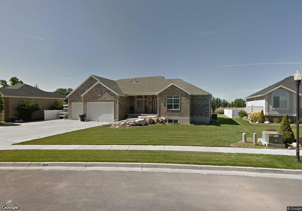
2640 S 1475 W Syracuse, UT 84075
Estimated Value: $622,000 - $826,000
3
Beds
3
Baths
2,408
Sq Ft
$298/Sq Ft
Est. Value
About This Home
This home is located at 2640 S 1475 W, Syracuse, UT 84075 and is currently estimated at $718,668, approximately $298 per square foot. 2640 S 1475 W is a home located in Davis County with nearby schools including Bluff Ridge Elementary, Legacy Junior High School, and Clearfield High School.
Ownership History
Date
Name
Owned For
Owner Type
Purchase Details
Closed on
May 24, 2005
Sold by
Nance Lionel M and Nance Elaine B
Bought by
Nance Keith W and Nance Carol
Current Estimated Value
Purchase Details
Closed on
Dec 11, 2003
Sold by
Nance Lionel M and Nance Elaine B
Bought by
Nance Keith W and Nance Carol
Purchase Details
Closed on
Aug 14, 2003
Sold by
Nance Elaine B and Nance Lionel M
Bought by
Nance Lionel M and Nance Elaine B
Purchase Details
Closed on
Aug 1, 2002
Sold by
Rainey Homes Inc
Bought by
Nance Lionel M and Nance Elaine B
Create a Home Valuation Report for This Property
The Home Valuation Report is an in-depth analysis detailing your home's value as well as a comparison with similar homes in the area
Home Values in the Area
Average Home Value in this Area
Purchase History
| Date | Buyer | Sale Price | Title Company |
|---|---|---|---|
| Nance Keith W | -- | Security Title | |
| Nance Keith W | -- | -- | |
| Nance Lionel M | -- | -- | |
| Nance Lionel M | -- | Heritage West Title Insuranc |
Source: Public Records
Tax History Compared to Growth
Tax History
| Year | Tax Paid | Tax Assessment Tax Assessment Total Assessment is a certain percentage of the fair market value that is determined by local assessors to be the total taxable value of land and additions on the property. | Land | Improvement |
|---|---|---|---|---|
| 2025 | $3,934 | $379,500 | $134,053 | $245,447 |
| 2024 | $3,737 | $363,000 | $120,187 | $242,813 |
| 2023 | $3,610 | $639,000 | $166,911 | $472,089 |
| 2022 | $3,690 | $358,050 | $94,762 | $263,288 |
| 2021 | $3,369 | $506,000 | $141,126 | $364,874 |
| 2020 | $3,115 | $453,000 | $118,206 | $334,794 |
| 2019 | $3,002 | $431,000 | $121,352 | $309,648 |
| 2018 | $2,772 | $395,000 | $114,044 | $280,956 |
| 2016 | $2,514 | $187,880 | $43,560 | $144,320 |
| 2015 | $2,700 | $192,170 | $43,560 | $148,610 |
| 2014 | $2,443 | $177,153 | $43,560 | $133,593 |
| 2013 | -- | $193,572 | $38,449 | $155,123 |
Source: Public Records
Map
Nearby Homes
- 2742 S Allison Way Unit 212
- 1667 W 2770 S Unit 206
- 2734 S Allison Way Unit 213
- 1280 W 2800 S
- 1315 W 2325 S
- 1295 W 2325 S
- 2766 S 1200 W
- 1306 W 2325 S
- 2480 S 1150 W
- 1286 W 2325 S
- 1137 W 2500 S
- 1276 W 2325 S
- 2958 S 1320 W
- 2876 S 1200 W
- 2208 W 2615 S Unit 141
- 2198 W 2615 S Unit 140
- 2158 W 2615 S Unit 137
- 2355 S 1230 W
- 1196 W 2325 S
- 2983 S 1765 W
- 2660 S 1475 W
- 2620 S 1475 W
- 2627 S 1475 W
- 2627 S 1475 W Unit 14
- 1511 W Barber Ln
- 2602 S 1475 W
- 1521 W Barber Ln
- 1486 W 2700 S
- 1462 W 2700 S
- 2645 S 1475 W
- 1522 W Barber Ln
- 1504 W 2700 S
- 2599 S 1475 W
- 2661 S 1475 W
- 2584 S 1475 W
- 2584 S 1475 W Unit 5
- 1531 W Barber Ln
- 1532 W Barber Ln
- 2681 S 1475 W
- 1526 W 2700 S