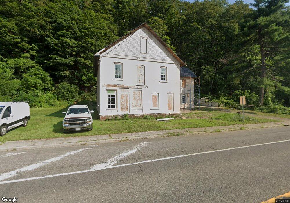
2645 State Route 12 Unit NYS Chenango Forks, NY 13746
Estimated Value: $49,122 - $168,000
8
Beds
3
Baths
3,788
Sq Ft
$30/Sq Ft
Est. Value
About This Home
This home is located at 2645 State Route 12 Unit NYS, Chenango Forks, NY 13746 and is currently estimated at $112,031, approximately $29 per square foot. 2645 State Route 12 Unit NYS is a home located in Broome County with nearby schools including Chenango Forks Elementary School, Chenango Forks Middle School, and Chenango Forks High School.
Ownership History
Date
Name
Owned For
Owner Type
Purchase Details
Closed on
Apr 26, 2023
Sold by
Budhiraja Deepak
Bought by
Braman Tavish
Current Estimated Value
Purchase Details
Closed on
Mar 7, 2022
Sold by
Jsk 1 Trading Inc
Bought by
Budhiraja Deepak
Purchase Details
Closed on
Nov 22, 2021
Sold by
Crawford Edwin L
Bought by
Jsk I Trading Inc
Purchase Details
Closed on
Jul 9, 2021
Sold by
Decker Michael T
Bought by
County Of Broome
Purchase Details
Closed on
Aug 29, 2018
Sold by
Broome County
Bought by
Race Mitchell B
Purchase Details
Closed on
Mar 31, 2014
Sold by
The County Of Broome
Bought by
Hj Us Holding Corporation
Purchase Details
Closed on
Feb 19, 2014
Sold by
Hamlin David C
Bought by
County Of Broome
Purchase Details
Closed on
Oct 10, 1997
Create a Home Valuation Report for This Property
The Home Valuation Report is an in-depth analysis detailing your home's value as well as a comparison with similar homes in the area
Home Values in the Area
Average Home Value in this Area
Purchase History
| Date | Buyer | Sale Price | Title Company |
|---|---|---|---|
| Braman Tavish | $39,000 | None Listed On Document | |
| Budhiraja Deepak | -- | None Listed On Document | |
| Jsk I Trading Inc | $1,000 | None Listed On Document | |
| County Of Broome | -- | None Available | |
| Race Mitchell B | $10,000 | None Available | |
| Hj Us Holding Corporation | $40,200 | None Available | |
| County Of Broome | -- | None Available | |
| -- | -- | -- |
Source: Public Records
Tax History Compared to Growth
Tax History
| Year | Tax Paid | Tax Assessment Tax Assessment Total Assessment is a certain percentage of the fair market value that is determined by local assessors to be the total taxable value of land and additions on the property. | Land | Improvement |
|---|---|---|---|---|
| 2024 | $1,372 | $40,000 | $19,100 | $20,900 |
| 2023 | $1,379 | $40,000 | $19,100 | $20,900 |
| 2022 | $1,346 | $40,000 | $19,100 | $20,900 |
| 2021 | $1,294 | $40,000 | $19,100 | $20,900 |
| 2020 | $2,378 | $40,000 | $19,100 | $20,900 |
| 2019 | -- | $40,000 | $19,100 | $20,900 |
| 2018 | $2,385 | $40,000 | $19,100 | $20,900 |
| 2017 | $2,357 | $40,000 | $19,100 | $20,900 |
| 2016 | $2,368 | $40,000 | $19,100 | $20,900 |
| 2015 | -- | $55,000 | $17,000 | $38,000 |
| 2014 | -- | $55,000 | $17,000 | $38,000 |
Source: Public Records
Map
Nearby Homes
- 13 Parsons Rd
- 15 River Ln
- 6633 State Route 79
- 6667 State Route 79
- 68 Marshman Rd
- 120 Steed Rd
- 226 Knapp Hill Rd
- 309 Parsons Rd
- 198 Conklin Hill Rd
- 248 County Road 1
- 4 Beartown Rd
- 446 Conklin Hill Rd
- 434 Cloverdale Rd
- 13 Warner Rd
- 1979 State Route 12
- 87 Pamela Dr
- 197 Port Rd
- 159 Beartown Rd
- 101 Palmer Hill Rd
- 603 Brotzman Rd
- 2625 State Highway 12
- 6509 State Route 79
- 6510 State Route 79
- 6502 State Route 79
- 6500 State Route 79
- 6496 State Route 79
- 6492 State Route 79
- 6488 State Route 79
- 433 Pigeon Hill Rd
- 6588 State Route 79
- 6585 State Route 79
- 6591 State Route 79
- 6478 State Route 79
- 6476 State Route 79
- 6600 State Route 79
- 45 Depot St
- 6468 State Route 79
- 6611 State Route 79
- 43 Depot St
- 365 Pigeon Hill Rd