Estimated Value: $292,000 - $383,000
3
Beds
2
Baths
1,691
Sq Ft
$195/Sq Ft
Est. Value
About This Home
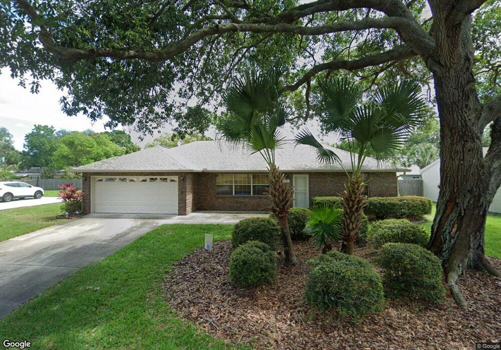
This home is located at 265 Capron Rd, Cocoa, FL 32927 and is currently estimated at $330,202, approximately $195 per square foot. 265 Capron Rd is a home located in Brevard County with nearby schools including Atlantis Elementary School, Space Coast Junior/Senior High School, and East Atlantic Prep of Brevard County.
Ownership History
Date
Name
Owned For
Owner Type
Purchase Details
Closed on
Nov 24, 2015
Sold by
Champagne Sidney A and Blankenship Robin R
Bought by
The Champagne Family Trust
Current Estimated Value
Purchase Details
Closed on
Dec 7, 1993
Sold by
Applegate Herbert L and Applegate Joan M
Bought by
Champagne Sidney A and Blankenship Robin R
Home Financials for this Owner
Home Financials are based on the most recent Mortgage that was taken out on this home.
Original Mortgage
$82,150
Interest Rate
6.85%
Create a Home Valuation Report for This Property
The Home Valuation Report is an in-depth analysis detailing your home's value as well as a comparison with similar homes in the area
Home Values in the Area
Average Home Value in this Area
Purchase History
| Date | Buyer | Sale Price | Title Company |
|---|---|---|---|
| The Champagne Family Trust | -- | Attorney | |
| Champagne Sidney A | $86,500 | -- |
Source: Public Records
Mortgage History
| Date | Status | Borrower | Loan Amount |
|---|---|---|---|
| Previous Owner | Champagne Sidney A | $82,150 |
Source: Public Records
Tax History
| Year | Tax Paid | Tax Assessment Tax Assessment Total Assessment is a certain percentage of the fair market value that is determined by local assessors to be the total taxable value of land and additions on the property. | Land | Improvement |
|---|---|---|---|---|
| 2025 | $1,560 | $114,930 | -- | -- |
| 2024 | $1,522 | $111,700 | -- | -- |
| 2023 | $1,522 | $108,450 | $0 | $0 |
| 2022 | $1,406 | $104,210 | $0 | $0 |
| 2021 | $1,408 | $101,180 | $0 | $0 |
| 2020 | $1,346 | $99,790 | $0 | $0 |
| 2019 | $1,168 | $89,480 | $0 | $0 |
| 2018 | $1,160 | $87,820 | $0 | $0 |
| 2017 | $1,151 | $86,020 | $0 | $0 |
| 2016 | $1,151 | $84,260 | $30,000 | $54,260 |
| 2015 | $993 | $71,760 | $15,000 | $56,760 |
| 2014 | $998 | $71,190 | $11,000 | $60,190 |
Source: Public Records
Map
Nearby Homes
- 000 Arabella Ln
- 0 Kanawha St
- 208 Capron Rd
- 214 Chase Rd
- 873 Dunbar St
- 865 Dunbar St
- 973 Poinsetta St
- 977 Poinsetta St
- 925 MacCo Rd
- 414 Oakridge Ave
- 361 Payne Ave
- 961 Kaufman St
- 7420 U S Route 1 Unit 106
- 7350 N Highway 1 Unit 201
- 7330 N Highway 1 Unit 206
- 7310 N Highway 1 Unit 201
- 7300 N Highway 1 Unit 104
- 7400 N Highway 1 Unit 105
- 7470 N Highway 1 Unit 105
- 1040 Jersey St
Your Personal Tour Guide
Ask me questions while you tour the home.