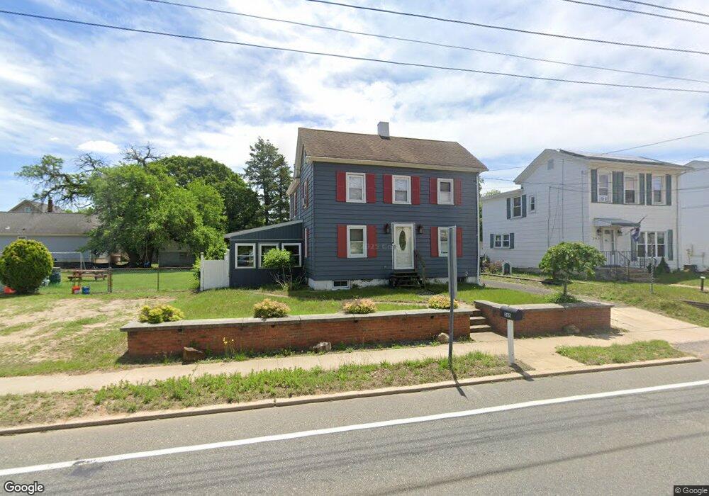
265 Crown Point Rd West Deptford, NJ 08086
West Deptford Township NeighborhoodEstimated Value: $246,941 - $314,000
--
Bed
--
Bath
1,494
Sq Ft
$196/Sq Ft
Est. Value
About This Home
This home is located at 265 Crown Point Rd, West Deptford, NJ 08086 and is currently estimated at $292,735, approximately $195 per square foot. 265 Crown Point Rd is a home located in Gloucester County with nearby schools including Red Bank Elementary School, Green-Fields Elementary School, and Oakview Elementary School.
Ownership History
Date
Name
Owned For
Owner Type
Purchase Details
Closed on
Feb 7, 2011
Sold by
Broszeit Max C and Marshall George
Bought by
Broszeit Max C
Current Estimated Value
Home Financials for this Owner
Home Financials are based on the most recent Mortgage that was taken out on this home.
Original Mortgage
$105,000
Outstanding Balance
$71,781
Interest Rate
4.76%
Mortgage Type
New Conventional
Estimated Equity
$220,954
Purchase Details
Closed on
Oct 11, 2005
Sold by
Marshall George
Bought by
Broszeit Max C and Marshall George
Purchase Details
Closed on
Sep 2, 2003
Sold by
Thompson Carol and Estate Of Raymond Lind
Bought by
Marshall George
Create a Home Valuation Report for This Property
The Home Valuation Report is an in-depth analysis detailing your home's value as well as a comparison with similar homes in the area
Home Values in the Area
Average Home Value in this Area
Purchase History
| Date | Buyer | Sale Price | Title Company |
|---|---|---|---|
| Broszeit Max C | -- | Old Republic National Title | |
| Broszeit Max C | -- | -- | |
| Marshall George | -- | -- |
Source: Public Records
Mortgage History
| Date | Status | Borrower | Loan Amount |
|---|---|---|---|
| Open | Broszeit Max C | $105,000 |
Source: Public Records
Tax History Compared to Growth
Tax History
| Year | Tax Paid | Tax Assessment Tax Assessment Total Assessment is a certain percentage of the fair market value that is determined by local assessors to be the total taxable value of land and additions on the property. | Land | Improvement |
|---|---|---|---|---|
| 2025 | $5,950 | $170,400 | $48,000 | $122,400 |
| 2024 | $5,874 | $170,400 | $48,000 | $122,400 |
| 2023 | $5,874 | $170,400 | $48,000 | $122,400 |
| 2022 | $5,846 | $170,400 | $48,000 | $122,400 |
| 2021 | $5,826 | $170,400 | $48,000 | $122,400 |
| 2020 | $5,812 | $170,400 | $48,000 | $122,400 |
| 2019 | $5,650 | $170,400 | $48,000 | $122,400 |
| 2018 | $5,497 | $170,400 | $48,000 | $122,400 |
| 2017 | $5,369 | $170,400 | $48,000 | $122,400 |
| 2016 | $5,219 | $170,400 | $48,000 | $122,400 |
| 2015 | $4,972 | $170,400 | $48,000 | $122,400 |
| 2014 | $4,725 | $170,400 | $48,000 | $122,400 |
Source: Public Records
Map
Nearby Homes
- 247 Crown Point Rd
- 97 Church St
- 433 Crown Point Rd
- 232 Snowy Egret Ln
- 439 Crown Point Rd
- 253 Snowy Egret Ln
- 6 Phoebe Terrace
- 64 Tilden Rd
- 47 Pelican Place Unit 47
- 67 Pelican Place
- 10 Kennedy Ct
- 124 Brent Ct
- 121 Cape May Ave
- 740 Carter Hill Dr
- 400 Audubon Ave
- 107 Audubon Ave
- 640 Worcester Dr
- 1810 Fernwood Dr
- 863 Doncaster Dr
- 266 Passaic Ave
- 263 Crown Point Rd
- 267 Crown Point Rd
- 64 Church St
- 66 Church St
- 262 Crown Point Rd
- 262 Crown Point Rd Unit A
- 262 Crown Point Rd Unit 2
- 259 Crown Point Rd
- 0 Church St Unit 1002524116
- 261 Crown Point Rd
- 68 Church St
- 257 Crown Point Rd
- 260 Crown Point Rd
- 70 Church St
- 255 Crown Point Rd
- 256 Crown Point Rd
- 254 Crown Point Rd
- 71 Church St
- 253 Crown Point Rd
- 252 Crown Point Rd