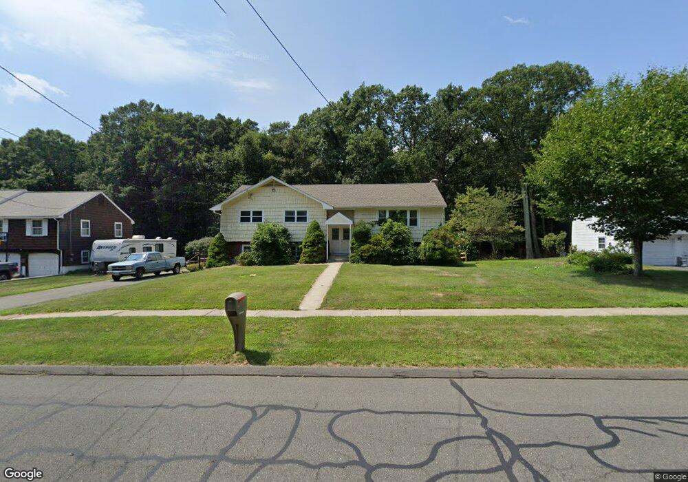
265 Goff Rd Wethersfield, CT 06109
Estimated Value: $403,000 - $458,197
3
Beds
3
Baths
1,505
Sq Ft
$295/Sq Ft
Est. Value
About This Home
This home is located at 265 Goff Rd, Wethersfield, CT 06109 and is currently estimated at $444,049, approximately $295 per square foot. 265 Goff Rd is a home located in Hartford County with nearby schools including Samuel B. Webb Elementary School, Silas Deane Middle School, and Wethersfield High School.
Ownership History
Date
Name
Owned For
Owner Type
Purchase Details
Closed on
Jun 20, 2016
Sold by
Lacapruccia Alfredo A
Bought by
Demarco Taylor L
Current Estimated Value
Purchase Details
Closed on
Jun 3, 2015
Sold by
Demarco Taylor
Bought by
Lacapruccia Alfred A
Home Financials for this Owner
Home Financials are based on the most recent Mortgage that was taken out on this home.
Original Mortgage
$75,000
Interest Rate
3.62%
Purchase Details
Closed on
Sep 18, 2013
Sold by
Dougherty Elizabeth
Bought by
Webber John E
Purchase Details
Closed on
Apr 26, 2013
Sold by
Lacapruccia Carmina
Bought by
Lacapruccia Alfredo A
Purchase Details
Closed on
May 29, 1996
Sold by
Krontz Max
Bought by
Lacapruccia Alfred and Lacapruccia Carmina
Create a Home Valuation Report for This Property
The Home Valuation Report is an in-depth analysis detailing your home's value as well as a comparison with similar homes in the area
Home Values in the Area
Average Home Value in this Area
Purchase History
| Date | Buyer | Sale Price | Title Company |
|---|---|---|---|
| Demarco Taylor L | -- | -- | |
| Lacapruccia Alfred A | -- | -- | |
| Webber John E | -- | -- | |
| Lacapruccia Alfredo A | -- | -- | |
| Lacapruccia Alfred | $165,000 | -- |
Source: Public Records
Mortgage History
| Date | Status | Borrower | Loan Amount |
|---|---|---|---|
| Previous Owner | Lacapruccia Alfred | $75,000 | |
| Previous Owner | Lacapruccia Alfred | $100,000 |
Source: Public Records
Tax History
| Year | Tax Paid | Tax Assessment Tax Assessment Total Assessment is a certain percentage of the fair market value that is determined by local assessors to be the total taxable value of land and additions on the property. | Land | Improvement |
|---|---|---|---|---|
| 2025 | $11,552 | $280,250 | $99,960 | $180,290 |
| 2024 | $7,481 | $173,090 | $65,790 | $107,300 |
| 2023 | $7,232 | $173,090 | $65,790 | $107,300 |
| 2022 | $7,111 | $173,090 | $65,790 | $107,300 |
| 2021 | $7,040 | $173,090 | $65,790 | $107,300 |
| 2020 | $7,043 | $173,090 | $65,790 | $107,300 |
| 2019 | $7,052 | $173,090 | $65,790 | $107,300 |
| 2018 | $6,859 | $168,200 | $64,900 | $103,300 |
| 2017 | $6,689 | $168,200 | $64,900 | $103,300 |
| 2016 | $6,482 | $168,200 | $64,900 | $103,300 |
| 2015 | $6,424 | $168,200 | $64,900 | $103,300 |
| 2014 | $6,180 | $168,200 | $64,900 | $103,300 |
Source: Public Records
Map
Nearby Homes
- 129 Goff Rd
- 20 Forest Dr
- 273 Forest Dr
- 15 Potter Crossing
- 7 Barrington Dr Unit C
- 25 Tinsmith Crossing
- 173 Timber Trail
- 62 Schoolhouse Crossing
- 764 Ridge Rd
- 274 Cedarwood Ln
- 144 Brown St
- 42 Dunham St
- 295 Ridge Rd Unit 8
- 519 Prospect St
- 55 Rutledge Rd
- 88 Hawley St
- 84 Connecticut Ave
- 0 Collier Rd
- 101 Collier Rd
- 158 Dix Rd
Your Personal Tour Guide
Ask me questions while you tour the home.