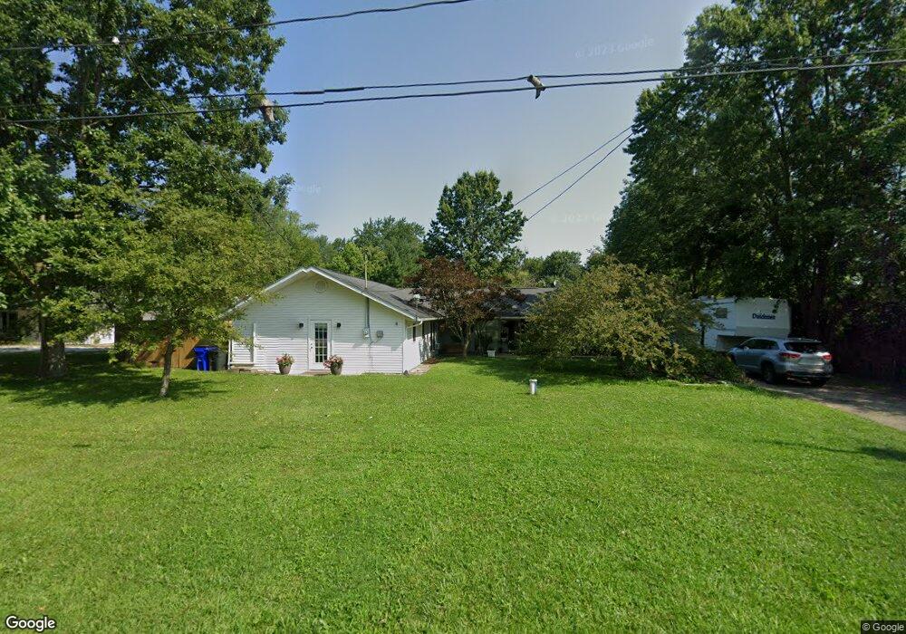
265 Hale Dr Streetsboro, OH 44241
Estimated Value: $250,000 - $422,000
4
Beds
2
Baths
2,642
Sq Ft
$132/Sq Ft
Est. Value
About This Home
This home is located at 265 Hale Dr, Streetsboro, OH 44241 and is currently estimated at $349,919, approximately $132 per square foot. 265 Hale Dr is a home located in Portage County with nearby schools including Campus Intermediate Elementary School, Henry Defer Intermediate Elementary School, and Streetsboro Middle School.
Ownership History
Date
Name
Owned For
Owner Type
Purchase Details
Closed on
Jan 4, 2001
Sold by
Allen Barbara H
Bought by
Rini Brett A and Rini Charolette A
Current Estimated Value
Home Financials for this Owner
Home Financials are based on the most recent Mortgage that was taken out on this home.
Original Mortgage
$100,000
Outstanding Balance
$37,512
Interest Rate
7.77%
Estimated Equity
$312,407
Purchase Details
Closed on
Nov 12, 1992
Bought by
Allen Barbara H and Allen Rini
Create a Home Valuation Report for This Property
The Home Valuation Report is an in-depth analysis detailing your home's value as well as a comparison with similar homes in the area
Home Values in the Area
Average Home Value in this Area
Purchase History
| Date | Buyer | Sale Price | Title Company |
|---|---|---|---|
| Rini Brett A | $32,800 | Americas Choice Title Agency | |
| Allen Barbara H | $83,000 | -- |
Source: Public Records
Mortgage History
| Date | Status | Borrower | Loan Amount |
|---|---|---|---|
| Open | Rini Brett A | $100,000 |
Source: Public Records
Tax History Compared to Growth
Tax History
| Year | Tax Paid | Tax Assessment Tax Assessment Total Assessment is a certain percentage of the fair market value that is determined by local assessors to be the total taxable value of land and additions on the property. | Land | Improvement |
|---|---|---|---|---|
| 2024 | $3,603 | $87,190 | $14,350 | $72,840 |
| 2023 | $2,882 | $57,090 | $14,350 | $42,740 |
| 2022 | $2,886 | $57,090 | $14,350 | $42,740 |
| 2021 | $2,897 | $57,090 | $14,350 | $42,740 |
| 2020 | $2,814 | $50,890 | $14,350 | $36,540 |
| 2019 | $2,840 | $50,890 | $14,350 | $36,540 |
| 2018 | $2,332 | $42,430 | $12,570 | $29,860 |
| 2017 | $2,332 | $42,430 | $12,570 | $29,860 |
| 2016 | $2,345 | $42,430 | $12,570 | $29,860 |
| 2015 | $2,360 | $42,430 | $12,570 | $29,860 |
| 2014 | $2,311 | $40,990 | $12,570 | $28,420 |
| 2013 | $2,325 | $40,990 | $12,570 | $28,420 |
Source: Public Records
Map
Nearby Homes
- 139 Mccracken Rd
- 9005 Sandpiper Dr
- 9011 Wood Thursh
- 8929 Falcon Dr
- 9085 Sandpiper Dr
- 792 State Route 303
- 701 Gold Leaf Ct
- 939 State Route 303
- 9251 Chestnut Ct
- 9247 Chestnut Ct
- 1011 Ashwood Ln
- 1013 Ashwood Ln
- 5361 Diana Lynn Dr
- 5890 Eastham Way
- 2798 E Celeste View Dr
- 1401 Colony Dr
- 9015 Patriot Dr Unit K4
- 708 Diane Ave
- 8795 Kelly Ln
- 572 David Dr