Estimated Value: $342,000 - $390,000
3
Beds
3
Baths
2,304
Sq Ft
$160/Sq Ft
Est. Value
About This Home
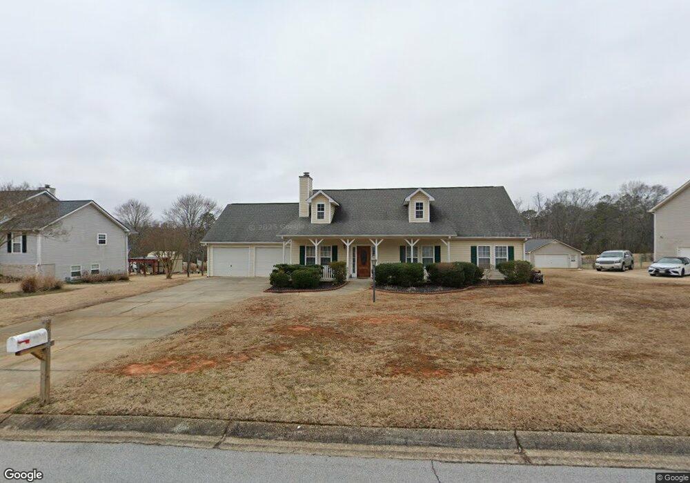
This home is located at 265 Hayes Trace, Hiram, GA 30141 and is currently estimated at $367,979, approximately $159 per square foot. 265 Hayes Trace is a home located in Paulding County with nearby schools including Bessie L. Baggett Elementary School, Irma C. Austin Middle School, and Hiram High School.
Ownership History
Date
Name
Owned For
Owner Type
Purchase Details
Closed on
Oct 1, 1998
Sold by
Contract Benchmark
Bought by
Jordan Elizabeth N
Current Estimated Value
Home Financials for this Owner
Home Financials are based on the most recent Mortgage that was taken out on this home.
Original Mortgage
$88,050
Outstanding Balance
$19,361
Interest Rate
6.95%
Mortgage Type
New Conventional
Estimated Equity
$348,618
Create a Home Valuation Report for This Property
The Home Valuation Report is an in-depth analysis detailing your home's value as well as a comparison with similar homes in the area
Home Values in the Area
Average Home Value in this Area
Purchase History
| Date | Buyer | Sale Price | Title Company |
|---|---|---|---|
| Jordan Elizabeth N | $110,100 | -- |
Source: Public Records
Mortgage History
| Date | Status | Borrower | Loan Amount |
|---|---|---|---|
| Open | Jordan Elizabeth N | $88,050 |
Source: Public Records
Tax History Compared to Growth
Tax History
| Year | Tax Paid | Tax Assessment Tax Assessment Total Assessment is a certain percentage of the fair market value that is determined by local assessors to be the total taxable value of land and additions on the property. | Land | Improvement |
|---|---|---|---|---|
| 2024 | $967 | $142,824 | $12,000 | $130,824 |
| 2023 | $1,077 | $135,484 | $12,000 | $123,484 |
| 2022 | $967 | $120,220 | $12,000 | $108,220 |
| 2021 | $825 | $84,032 | $10,000 | $74,032 |
| 2020 | $944 | $90,196 | $10,000 | $80,196 |
| 2019 | $803 | $74,592 | $10,000 | $64,592 |
| 2018 | $607 | $57,964 | $10,000 | $47,964 |
| 2017 | $712 | $65,040 | $10,000 | $55,040 |
| 2016 | $684 | $64,200 | $10,000 | $54,200 |
| 2015 | $677 | $61,160 | $10,000 | $51,160 |
| 2014 | $586 | $50,560 | $10,000 | $40,560 |
| 2013 | -- | $35,680 | $8,000 | $27,680 |
Source: Public Records
Map
Nearby Homes
- 285 Hayes Trace
- 285 Hayes Trace Unit 13
- 20 Mallory Ct
- 40 Mallory Ct
- 295 Hayes Trace
- 270 Hayes Trace
- 250 Hayes Trace
- 297 Hayes Trace
- 290 Hayes Trace
- 230 Hayes Trace
- 46 Mallory Ct
- 50 Mallory Ct
- 296 Hayes Terrace
- 210 Hayes Trace
- 185 Hayes Trace Unit 6
- 185 Hayes Trace
- 43 Mallory Ct
- 172 Richards Way
- 12 Farmers Ct
- 0 Hayes Trace Unit 8661456