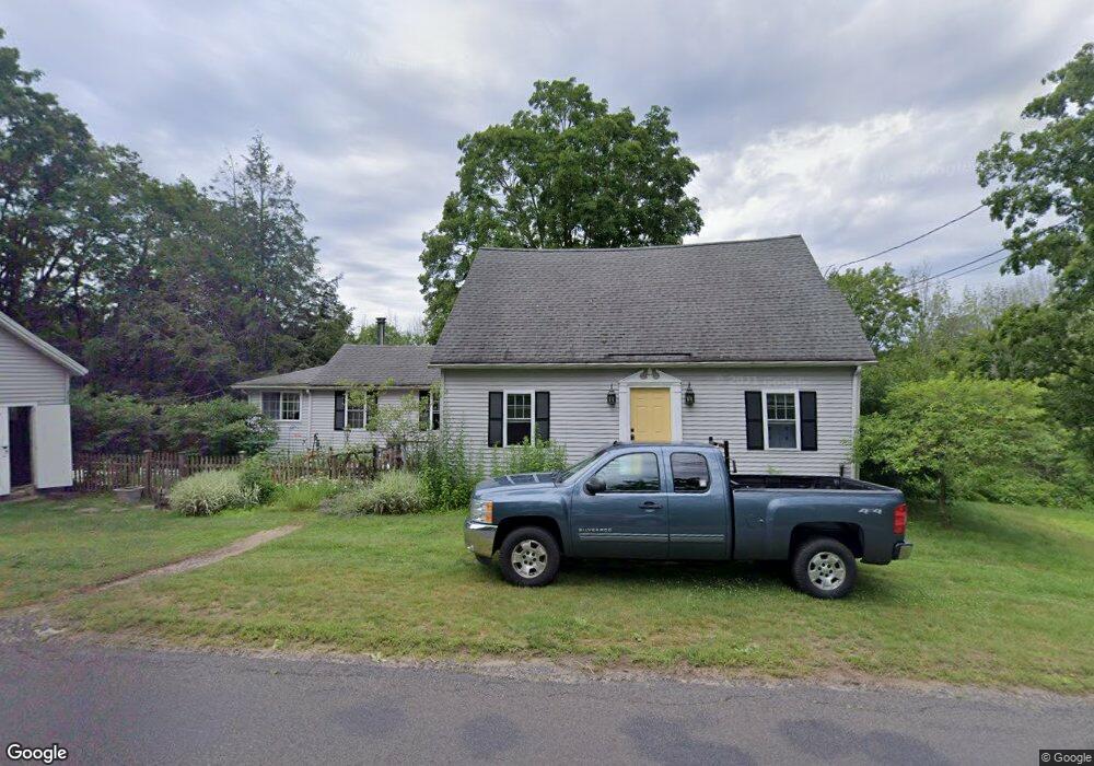
265 Locust Rd Harwinton, CT 06791
Estimated Value: $451,025 - $475,000
2
Beds
3
Baths
1,610
Sq Ft
$287/Sq Ft
Est. Value
About This Home
This home is located at 265 Locust Rd, Harwinton, CT 06791 and is currently estimated at $462,506, approximately $287 per square foot. 265 Locust Rd is a home located in Litchfield County with nearby schools including Harwinton Consolidated School, Har-Bur Middle School, and Lewis S. Mills High School.
Ownership History
Date
Name
Owned For
Owner Type
Purchase Details
Closed on
Jan 13, 2005
Sold by
Barbieri Joseph A
Bought by
Slowik Mark B and Slowik Julie S
Current Estimated Value
Home Financials for this Owner
Home Financials are based on the most recent Mortgage that was taken out on this home.
Original Mortgage
$270,000
Interest Rate
5.81%
Purchase Details
Closed on
Apr 15, 2003
Sold by
Household Senior Svcs
Bought by
Barbieri Joseph A
Create a Home Valuation Report for This Property
The Home Valuation Report is an in-depth analysis detailing your home's value as well as a comparison with similar homes in the area
Home Values in the Area
Average Home Value in this Area
Purchase History
| Date | Buyer | Sale Price | Title Company |
|---|---|---|---|
| Slowik Mark B | $270,000 | -- | |
| Slowik Mark B | $270,000 | -- | |
| Barbieri Joseph A | $115,900 | -- | |
| Barbieri Joseph A | $115,900 | -- |
Source: Public Records
Mortgage History
| Date | Status | Borrower | Loan Amount |
|---|---|---|---|
| Closed | Barbieri Joseph A | $240,000 | |
| Closed | Barbieri Joseph A | $260,000 | |
| Closed | Barbieri Joseph A | $270,000 |
Source: Public Records
Tax History Compared to Growth
Tax History
| Year | Tax Paid | Tax Assessment Tax Assessment Total Assessment is a certain percentage of the fair market value that is determined by local assessors to be the total taxable value of land and additions on the property. | Land | Improvement |
|---|---|---|---|---|
| 2025 | $4,602 | $200,090 | $74,380 | $125,710 |
| 2024 | $4,582 | $200,090 | $74,380 | $125,710 |
| 2023 | $3,631 | $124,360 | $53,130 | $71,230 |
| 2022 | $3,544 | $124,360 | $53,130 | $71,230 |
| 2021 | $3,569 | $124,360 | $53,130 | $71,230 |
| 2020 | $3,482 | $124,360 | $53,130 | $71,230 |
| 2019 | $3,482 | $124,360 | $53,130 | $71,230 |
| 2018 | $3,913 | $139,750 | $70,040 | $69,710 |
| 2017 | $3,885 | $139,750 | $70,040 | $69,710 |
| 2016 | $3,885 | $139,750 | $70,040 | $69,710 |
| 2015 | $3,815 | $139,750 | $70,040 | $69,710 |
| 2014 | $3,759 | $139,750 | $70,040 | $69,710 |
Source: Public Records
Map
Nearby Homes
- 25 Plymouth Rd
- 83 Shingle Mill Rd
- 28 Lily Pond Rd
- 21 South Rd
- 12 Break Maiden Ln
- 66 Warren Glen
- 67 Warren Glen
- 164 Birge Park Rd
- 9 Steeple Chase Rd
- 2 Warren Glen
- 195 County Line Rd
- 29 Partridge Ln
- 75 Saw Mill Rd
- 76 Charolais Way
- 74 Pine Ridge Dr
- 183 Wildcat Hill Rd
- 92 Shafer Rd
- 530 Wildcat Hill Rd
- 39 Orchard Hill Rd
- 448 Litchfield Rd