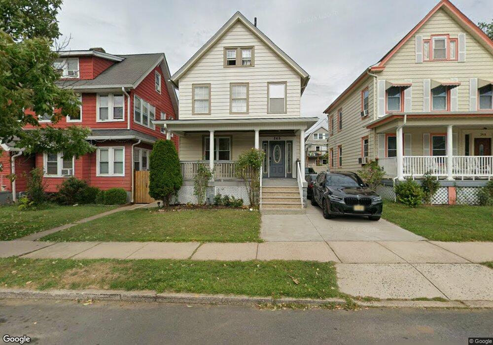
265 Powers St New Brunswick, NJ 08901
Estimated Value: $330,188 - $433,000
--
Bed
--
Bath
1,614
Sq Ft
$246/Sq Ft
Est. Value
About This Home
This home is located at 265 Powers St, New Brunswick, NJ 08901 and is currently estimated at $396,297, approximately $245 per square foot. 265 Powers St is a home located in Middlesex County with nearby schools including New Brunswick High School, Central Jersey College Prep Charter School, and St. Mary of Mount Virgin School.
Ownership History
Date
Name
Owned For
Owner Type
Purchase Details
Closed on
Jul 12, 2002
Sold by
Mcfarland Anthony
Bought by
Garcia Uriel
Current Estimated Value
Home Financials for this Owner
Home Financials are based on the most recent Mortgage that was taken out on this home.
Original Mortgage
$137,000
Interest Rate
6.17%
Mortgage Type
FHA
Purchase Details
Closed on
Sep 2, 1999
Sold by
Murray James
Bought by
Mcfarland Anthony and Mcfarland Dawn
Home Financials for this Owner
Home Financials are based on the most recent Mortgage that was taken out on this home.
Original Mortgage
$116,400
Interest Rate
7.5%
Create a Home Valuation Report for This Property
The Home Valuation Report is an in-depth analysis detailing your home's value as well as a comparison with similar homes in the area
Home Values in the Area
Average Home Value in this Area
Purchase History
| Date | Buyer | Sale Price | Title Company |
|---|---|---|---|
| Garcia Uriel | $165,000 | -- | |
| Mcfarland Anthony | $120,000 | -- |
Source: Public Records
Mortgage History
| Date | Status | Borrower | Loan Amount |
|---|---|---|---|
| Previous Owner | Garcia Uriel | $137,000 | |
| Previous Owner | Mcfarland Anthony | $116,400 |
Source: Public Records
Tax History Compared to Growth
Tax History
| Year | Tax Paid | Tax Assessment Tax Assessment Total Assessment is a certain percentage of the fair market value that is determined by local assessors to be the total taxable value of land and additions on the property. | Land | Improvement |
|---|---|---|---|---|
| 2025 | $4,429 | $169,100 | $77,500 | $91,600 |
| 2024 | $4,300 | $169,100 | $77,500 | $91,600 |
| 2023 | $4,300 | $169,100 | $77,500 | $91,600 |
| 2022 | $4,209 | $169,100 | $77,500 | $91,600 |
| 2021 | $3,117 | $169,100 | $77,500 | $91,600 |
| 2020 | $4,177 | $169,100 | $77,500 | $91,600 |
| 2019 | $4,097 | $169,100 | $77,500 | $91,600 |
| 2018 | $4,004 | $169,100 | $77,500 | $91,600 |
| 2017 | $3,845 | $169,100 | $77,500 | $91,600 |
| 2016 | $5,320 | $90,700 | $24,000 | $66,700 |
| 2015 | $5,193 | $90,700 | $24,000 | $66,700 |
| 2014 | $5,101 | $90,700 | $24,000 | $66,700 |
Source: Public Records
Map
Nearby Homes
- 294 Howard St
- 11 Edgeworth Place
- 130 Joyce Kilmer Ave
- 14 Edgeworth Place
- 158 Lee Ave
- 114 Joyce Kilmer Ave
- 200 Talmadge St
- 163 Livingston Ave
- 216 Handy St
- 201 Fulton St
- 267 Handy St
- 25 Rutgers St
- 264 Seaman St
- 184 Lawrence St
- 375 Delavan St
- 47 Jersey Ave
- 340 Livingston Ave
- 128 Remsen Ave Unit A
- 128A Remsen Ave
- 122 Lawrence St Unit 26
- 267 Powers St
- 267 Powers St Unit 2
- 263 Powers St
- 269 Powers St
- 261 Powers St
- 271 Powers St
- 276 Sandford St
- 274 Sandford St
- 278 Sandford St
- 259 Powers St
- 259 Powers St Unit 1st f
- 259 Powers St Unit A
- 272 Sandford St
- 154 Joyce Kilmer Ave
- 268 Sandford St
- 152 Joyce Kilmer Ave
- 273 Powers St
- 257 Powers St
- 266 Sandford St
- 148 Joyce Kilmer Ave