Estimated Value: $242,000 - $327,000
2
Beds
2
Baths
903
Sq Ft
$336/Sq Ft
Est. Value
About This Home
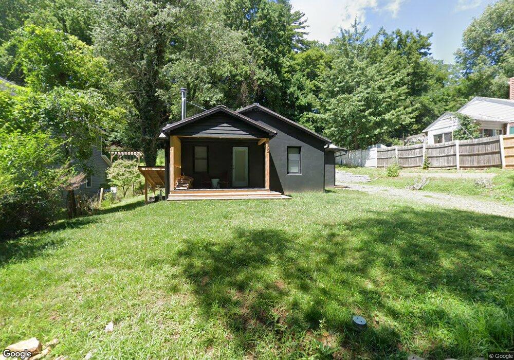
This home is located at 265 Westbrook Dr, Boone, NC 28607 and is currently estimated at $303,728, approximately $336 per square foot. 265 Westbrook Dr is a home located in Watauga County with nearby schools including Hardin Park Elementary School, Watauga High School, and Mountain Pathways School.
Ownership History
Date
Name
Owned For
Owner Type
Purchase Details
Closed on
Oct 11, 2024
Sold by
265 Westbrook Llc
Bought by
Buxbaum Jonathan J and Buxbaum Mara L
Current Estimated Value
Purchase Details
Closed on
Sep 9, 2019
Sold by
Seaside Family Limited Partnership
Bought by
265 Westbrook Llc
Home Financials for this Owner
Home Financials are based on the most recent Mortgage that was taken out on this home.
Original Mortgage
$90,000
Interest Rate
3.7%
Mortgage Type
Commercial
Purchase Details
Closed on
Feb 26, 2015
Sold by
Hopkins Fred Stephen
Bought by
Seaside Family Limited Partnership
Create a Home Valuation Report for This Property
The Home Valuation Report is an in-depth analysis detailing your home's value as well as a comparison with similar homes in the area
Home Values in the Area
Average Home Value in this Area
Purchase History
| Date | Buyer | Sale Price | Title Company |
|---|---|---|---|
| Buxbaum Jonathan J | -- | None Listed On Document | |
| 265 Westbrook Llc | $100,000 | None Available | |
| Seaside Family Limited Partnership | -- | None Available |
Source: Public Records
Mortgage History
| Date | Status | Borrower | Loan Amount |
|---|---|---|---|
| Previous Owner | 265 Westbrook Llc | $90,000 |
Source: Public Records
Tax History
| Year | Tax Paid | Tax Assessment Tax Assessment Total Assessment is a certain percentage of the fair market value that is determined by local assessors to be the total taxable value of land and additions on the property. | Land | Improvement |
|---|---|---|---|---|
| 2025 | $746 | $192,000 | $55,600 | $136,400 |
| 2024 | $7 | $191,400 | $55,600 | $135,800 |
| 2023 | $1,523 | $139,000 | $55,600 | $83,400 |
| 2022 | $1,523 | $139,000 | $55,600 | $83,400 |
| 2021 | $948 | $103,000 | $42,800 | $60,200 |
| 2020 | $917 | $103,000 | $42,800 | $60,200 |
| 2019 | $899 | $100,700 | $40,500 | $60,200 |
| 2018 | $848 | $100,700 | $40,500 | $60,200 |
| 2017 | $848 | $100,700 | $40,500 | $60,200 |
| 2013 | -- | $92,100 | $30,400 | $61,700 |
Source: Public Records
Map
Nearby Homes
- 192 & 206 Orchard St
- 713 W King St
- 380 W King St
- 890 W King St
- 1358 W King St
- 289 Ninebark Rd
- 127 Sun Haven Ln
- 229 E King St Unit 9
- 229 E King St Unit 23
- 134 Mac St Unit 10
- 229 Old Bristol Rd
- 137 Stoneybrook Ct Unit 102
- 530 Howards Knob Rd
- 35 acres Poplar Grove Rd
- TBD Market Hills Dr
- 366 Dove Cir
- 286 Faculty St Unit 201
- 1180 Pinnacle Dr
- 668 Dogwood Rd
- 164 Appalachian Dr
- 255 Westbrook Dr
- 283 Westbrook Dr
- 245 Westbrook Dr
- 397 Grand Blvd
- 303 Westbrook Dr
- 417 Grand Blvd Unit A
- 417 Grand Blvd Unit B
- 417 Grand Blvd
- 385 Grand Blvd
- 435 Grand Blvd
- 219 Westbrook Dr
- 377 Grand Blvd
- 402 Grand Blvd
- 315 Westbrook Dr
- 378 Grand Blvd
- 443 Grand Blvd
- 365 Grand Blvd
- 436 Grand Blvd
- 229 Eastbrook Dr
- 218 Westbrook Dr
Your Personal Tour Guide
Ask me questions while you tour the home.