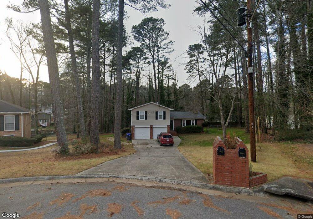
2651 Michael Cir Duluth, GA 30096
Estimated Value: $333,000 - $353,000
3
Beds
2
Baths
1,580
Sq Ft
$216/Sq Ft
Est. Value
About This Home
This home is located at 2651 Michael Cir, Duluth, GA 30096 and is currently estimated at $341,796, approximately $216 per square foot. 2651 Michael Cir is a home located in Gwinnett County with nearby schools including B.B. Harris Elementary School, Duluth Middle School, and Duluth High School.
Ownership History
Date
Name
Owned For
Owner Type
Purchase Details
Closed on
Sep 24, 2020
Sold by
Stein Charles E and Stein Patricia I
Bought by
Portillo Carol Ann
Current Estimated Value
Purchase Details
Closed on
May 18, 2016
Sold by
Stein Charles E
Bought by
Sawdey Bonnie C Trustee
Purchase Details
Closed on
Aug 16, 2000
Sold by
Stein Charles E
Bought by
Stein Patricia R
Create a Home Valuation Report for This Property
The Home Valuation Report is an in-depth analysis detailing your home's value as well as a comparison with similar homes in the area
Home Values in the Area
Average Home Value in this Area
Purchase History
| Date | Buyer | Sale Price | Title Company |
|---|---|---|---|
| Portillo Carol Ann | -- | -- | |
| Sawdey Bonnie C Trustee | -- | -- | |
| Stein Patricia R | -- | -- |
Source: Public Records
Tax History
| Year | Tax Paid | Tax Assessment Tax Assessment Total Assessment is a certain percentage of the fair market value that is determined by local assessors to be the total taxable value of land and additions on the property. | Land | Improvement |
|---|---|---|---|---|
| 2025 | $3,763 | $127,440 | $29,920 | $97,520 |
| 2024 | $3,686 | $117,760 | $28,800 | $88,960 |
| 2023 | $3,686 | $107,200 | $22,000 | $85,200 |
| 2022 | $3,424 | $107,200 | $22,000 | $85,200 |
| 2021 | $2,777 | $74,360 | $16,000 | $58,360 |
| 2020 | $3,016 | $74,360 | $16,000 | $58,360 |
| 2019 | $2,762 | $70,200 | $14,800 | $55,400 |
| 2018 | $2,431 | $60,760 | $14,800 | $45,960 |
| 2016 | $2,045 | $49,240 | $12,000 | $37,240 |
| 2015 | $1,762 | $41,400 | $8,000 | $33,400 |
| 2014 | $1,769 | $41,360 | $8,000 | $33,360 |
Source: Public Records
Map
Nearby Homes
- 2702 Davenport Rd
- 3576 Randy Place
- 2708 Irene Cir
- 2648 Irene Cir
- 3493 Citrus Dr
- 3412 Davenport Park Ln
- 3215 Oxwell Dr Unit 1B
- 2830 Meadow Lark Trail
- 3053 Hartright Bend Ct
- 3118 Hampton Ives Ct NW
- 2829 Cardinal Trace
- 3518 Tracey Dr
- 2878 Cardinal Trace
- 2816 Cardinal Lake Cir NW
- 3695 Woodberry Dr
- 2678 Hummingbird Dr NW
- 2535 Rhoanoke Dr
- 2961 Creek Dr
- 2869 Winchester Ct
- 2509 Village Park Bend
- 2641 Michael Cir
- 2641 Michael Cir NW
- 5122 Micae Way
- 2660 Michael Cir
- 2654 Davenport Rd
- 2674 Davenport Rd
- 2650 Michael Cir NW
- 2631 Michael Cir NW
- 2631 Michael Cir
- 2634 Davenport Rd
- 2684 Davenport Rd Unit 8
- 2684 Davenport Rd
- 2650 Michael Cir
- 2640 Michael Cir
- 2624 Davenport Rd
- 2779 Irene Cir
- 2621 Michael Cir
- 2630 Michael Cir
- 2769 Irene Cir
- 2614 Davenport Rd
Your Personal Tour Guide
Ask me questions while you tour the home.