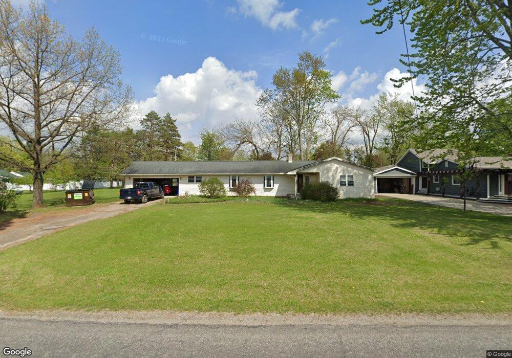
2657 Airport Rd Adrian, MI 49221
Estimated Value: $194,933 - $223,000
2
Beds
1
Bath
1,493
Sq Ft
$142/Sq Ft
Est. Value
About This Home
This home is located at 2657 Airport Rd, Adrian, MI 49221 and is currently estimated at $212,733, approximately $142 per square foot. 2657 Airport Rd is a home located in Lenawee County with nearby schools including Adrian High School, Berean Baptist Academy, and St. Stephen Lutheran School.
Ownership History
Date
Name
Owned For
Owner Type
Purchase Details
Closed on
May 21, 2015
Sold by
Richardson Jacqueline M
Bought by
Richardson Mivhael J
Current Estimated Value
Home Financials for this Owner
Home Financials are based on the most recent Mortgage that was taken out on this home.
Original Mortgage
$74,200
Outstanding Balance
$57,057
Interest Rate
3.63%
Mortgage Type
New Conventional
Estimated Equity
$155,676
Purchase Details
Closed on
Jan 28, 2000
Bought by
Richardson Michael J
Create a Home Valuation Report for This Property
The Home Valuation Report is an in-depth analysis detailing your home's value as well as a comparison with similar homes in the area
Home Values in the Area
Average Home Value in this Area
Purchase History
| Date | Buyer | Sale Price | Title Company |
|---|---|---|---|
| Richardson Mivhael J | -- | Prestige Title Insurance Age | |
| Richardson Michael J | -- | -- |
Source: Public Records
Mortgage History
| Date | Status | Borrower | Loan Amount |
|---|---|---|---|
| Open | Richardson Mivhael J | $74,200 |
Source: Public Records
Tax History
| Year | Tax Paid | Tax Assessment Tax Assessment Total Assessment is a certain percentage of the fair market value that is determined by local assessors to be the total taxable value of land and additions on the property. | Land | Improvement |
|---|---|---|---|---|
| 2025 | $1,758 | $88,600 | $0 | $0 |
| 2024 | $10 | $79,700 | $0 | $0 |
| 2022 | $920 | $62,500 | $0 | $0 |
| 2021 | $2,289 | $60,000 | $0 | $0 |
| 2020 | $2,071 | $60,400 | $0 | $0 |
| 2019 | $138,388 | $51,600 | $0 | $0 |
| 2018 | $1,550 | $51,622 | $0 | $0 |
| 2017 | $1,495 | $51,648 | $0 | $0 |
| 2016 | $1,733 | $49,048 | $0 | $0 |
| 2014 | -- | $46,034 | $0 | $0 |
Source: Public Records
Map
Nearby Homes
- 2673 Airport Rd
- 2455 W Cadmus Rd
- 2029 Green Acres Dr
- 2018 Green Acres Dr
- 2012 Green Acres Dr
- 2010 Green Acres Dr
- 2016 Green Acres Dr
- 2008 Green Acres Dr
- 2026 Green Acres Dr
- 2004 Green Acres Dr
- 2303 Lakewood Dr
- 1637 Rivers Edge Ct
- 1639 Rivers Edge Ct
- 1641 Rivers Edge Ct
- 909 Savannah River Dr
- 809 Missouri River Dr
- 521 Rio Grande Dr
- 301 Hidden River Dr
- 1335 Spencer Place
- 217 Red River Dr
- 2629 Airport Rd
- 2687 Airport Rd
- 2699 Airport Rd
- 2547 Macarthur Dr
- 2601 Airport Rd
- 2531 Macarthur Dr
- 2605 Airport Rd
- 2715 Airport Rd
- 2540 Macarthur Dr
- 2662 Sharon Dr
- 2548 Macarthur Dr
- 2670 Sharon Dr
- 2526 Macarthur Dr
- 2617 Sharon Dr
- 2678 Sharon Dr
- 2511 Macarthur Dr
- 2729 Airport Rd
- 2681 Sharon Dr
- 2687 Sharon Dr
- 2501 Macarthur Dr
Your Personal Tour Guide
Ask me questions while you tour the home.