Estimated Value: $816,000 - $966,646
3
Beds
2
Baths
1,215
Sq Ft
$730/Sq Ft
Est. Value
About This Home
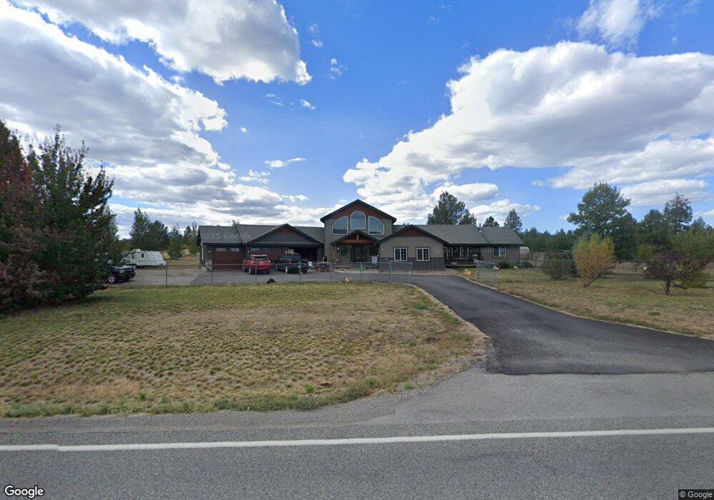
This home is located at 26579 N Old Highway 95, Athol, ID 83801 and is currently estimated at $886,882, approximately $729 per square foot. 26579 N Old Highway 95 is a home located in Kootenai County with nearby schools including Athol Elementary School, Timberlake Junior High School, and Timberlake Senior High School.
Ownership History
Date
Name
Owned For
Owner Type
Purchase Details
Closed on
Feb 26, 2014
Sold by
Burgess Kathleen L and Burgess Girard L
Bought by
Wohali Moses M and Wohali Denelle J
Current Estimated Value
Home Financials for this Owner
Home Financials are based on the most recent Mortgage that was taken out on this home.
Original Mortgage
$127,300
Outstanding Balance
$96,352
Interest Rate
4.38%
Mortgage Type
New Conventional
Estimated Equity
$790,530
Purchase Details
Closed on
May 4, 2006
Sold by
Burgess Girard L and Burgess Kathleen L
Bought by
Burges Kathleen L
Home Financials for this Owner
Home Financials are based on the most recent Mortgage that was taken out on this home.
Original Mortgage
$193,600
Interest Rate
9.95%
Mortgage Type
Adjustable Rate Mortgage/ARM
Create a Home Valuation Report for This Property
The Home Valuation Report is an in-depth analysis detailing your home's value as well as a comparison with similar homes in the area
Home Values in the Area
Average Home Value in this Area
Purchase History
| Date | Buyer | Sale Price | Title Company |
|---|---|---|---|
| Wohali Moses M | -- | Alliance Title | |
| Burges Kathleen L | -- | -- |
Source: Public Records
Mortgage History
| Date | Status | Borrower | Loan Amount |
|---|---|---|---|
| Open | Wohali Moses M | $127,300 | |
| Previous Owner | Burges Kathleen L | $193,600 |
Source: Public Records
Tax History Compared to Growth
Tax History
| Year | Tax Paid | Tax Assessment Tax Assessment Total Assessment is a certain percentage of the fair market value that is determined by local assessors to be the total taxable value of land and additions on the property. | Land | Improvement |
|---|---|---|---|---|
| 2025 | $2,500 | $942,770 | $414,460 | $528,310 |
| 2024 | $2,500 | $822,748 | $304,828 | $517,920 |
| 2023 | $2,500 | $916,000 | $361,828 | $554,172 |
| 2022 | $2,933 | $858,812 | $304,640 | $554,172 |
| 2021 | $3,323 | $610,616 | $202,896 | $407,720 |
| 2020 | $3,098 | $485,000 | $155,070 | $329,930 |
| 2019 | $3,234 | $449,089 | $139,239 | $309,850 |
| 2018 | $3,058 | $389,351 | $118,021 | $271,330 |
| 2017 | $2,507 | $314,309 | $97,629 | $216,680 |
| 2016 | $1,129 | $170,278 | $75,968 | $94,310 |
| 2015 | $1,081 | $146,955 | $53,625 | $93,330 |
| 2013 | $998 | $139,147 | $56,407 | $82,740 |
Source: Public Records
Map
Nearby Homes
- Lot 11 Asulkan St
- Lot 13 Asulkan St
- Lot 20 Asulkan St
- Lot 6 Dawson Lp
- Lot 7 Dawson Lp
- Lot 9 Dawson Lp
- Lot 12 Asulkan St
- Lot 8 Dawson Lp
- Lot 14 Asulkan St
- Lot 17 Asulkan St
- Lot 16 Asulkan St
- Lot 15 Asulkan St
- Lot 19 Asulkan St
- Lot 1 Dawson Lp
- Lot 3 Dawson Lp
- Lot 4 Dawson Lp
- 28789 N Highway 95
- NKA N Targhee St
- 0 E Son Shine Way
- NKA E Son Shine Way
- 26687 N Old Highway 95
- 26453 N Old Highway 95
- 26445 N Old Highway 95
- NKA Asulkan St
- 4761 E Lupin Ln
- 4705 E Lupin Ln
- 4980 E Bear Grass Ct
- 4876 E Beargrass Ct
- 4659 E Lupin Ln
- 26804 Old Highway 95
- 27644 N Silver Meadows Loop
- 27566 N Silver Meadows Loop
- 4607 E Lupin Ln
- 5000 E Bear Grass Ct
- 27408 N Silver Meadows Loop
- 4515 E Lupin Ln
- 4676 E Lupin Ln
- 27340 N Silver Meadows Loop
- 26144 N Old Highway 95
- 27786 N Silver Meadows Loop