Estimated Value: $154,000 - $231,000
3
Beds
2
Baths
1,703
Sq Ft
$117/Sq Ft
Est. Value
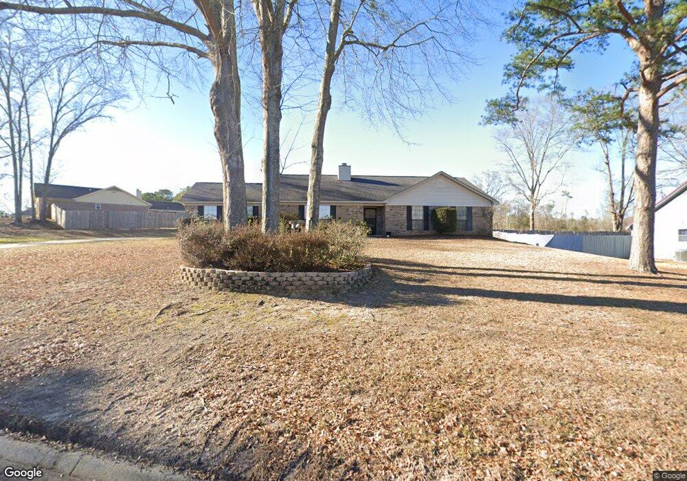
About This Home
This home is located at 266 Blake Dr, Ozark, AL 36360 and is currently estimated at $199,667, approximately $117 per square foot. 266 Blake Dr is a home located in Dale County with nearby schools including Lisenby Primary School, Mixon Intermediate School, and D. A. Smith Middle School.
Ownership History
Date
Name
Owned For
Owner Type
Purchase Details
Closed on
Sep 5, 2023
Sold by
Parr Bobby and Parr Barbara
Bought by
Tapia Michael A and Tapia Shannon
Current Estimated Value
Purchase Details
Closed on
Aug 17, 2023
Sold by
Parr Bobby and Parr Barbara
Bought by
Tapia Michael A and Tapia Shannon
Purchase Details
Closed on
Nov 18, 2007
Sold by
Murphy Patrick J and Murphy Kevin J
Bought by
Parr Bobby and Parr Barbara
Create a Home Valuation Report for This Property
The Home Valuation Report is an in-depth analysis detailing your home's value as well as a comparison with similar homes in the area
Home Values in the Area
Average Home Value in this Area
Purchase History
| Date | Buyer | Sale Price | Title Company |
|---|---|---|---|
| Tapia Michael A | $500 | None Listed On Document | |
| Tapia Michael A | $500 | None Listed On Document | |
| Parr Bobby | $112,500 | -- |
Source: Public Records
Tax History Compared to Growth
Tax History
| Year | Tax Paid | Tax Assessment Tax Assessment Total Assessment is a certain percentage of the fair market value that is determined by local assessors to be the total taxable value of land and additions on the property. | Land | Improvement |
|---|---|---|---|---|
| 2024 | $1,797 | $35,580 | $1,700 | $33,880 |
| 2023 | $1,797 | $30,800 | $1,600 | $29,200 |
| 2022 | $1,270 | $25,140 | $25,140 | $0 |
| 2021 | $1,182 | $23,400 | $1,600 | $21,800 |
| 2020 | $1,255 | $24,860 | $1,600 | $23,260 |
| 2019 | $1,255 | $24,860 | $1,600 | $23,260 |
| 2018 | $1,190 | $23,560 | $1,600 | $21,960 |
| 2017 | $1,190 | $23,560 | $1,600 | $21,960 |
| 2016 | $1,190 | $11,780 | $800 | $10,980 |
| 2015 | $1,190 | $23,560 | $1,600 | $21,960 |
| 2014 | $1,171 | $23,180 | $1,600 | $21,580 |
| 2013 | $1,159 | $23,180 | $1,600 | $21,580 |
Source: Public Records
Map
Nearby Homes
- 236 Shulsen Dr
- 748 Willow Oaks Dr
- 178 Jasmine Dr
- 130 Stephanie Dr
- 127 Peters Cir
- 3095 Andrews Ave
- 424 Merrydell Dr
- 1192 Campground Rd
- 262 Rosemary Ln
- 240 Bradford Dr
- 1401 Deese Rd
- TBD Andrews Ave
- Lot 6 & 7 Brookwood Brookwood Cir
- 876 Camilla Ave
- 0 Deese Rd
- 1.144 Acres S Highway 231
- 0 U S 231
- Lot 4 U S 231
- Lot 5 U S 231
- 615 Rolling Hills Dr