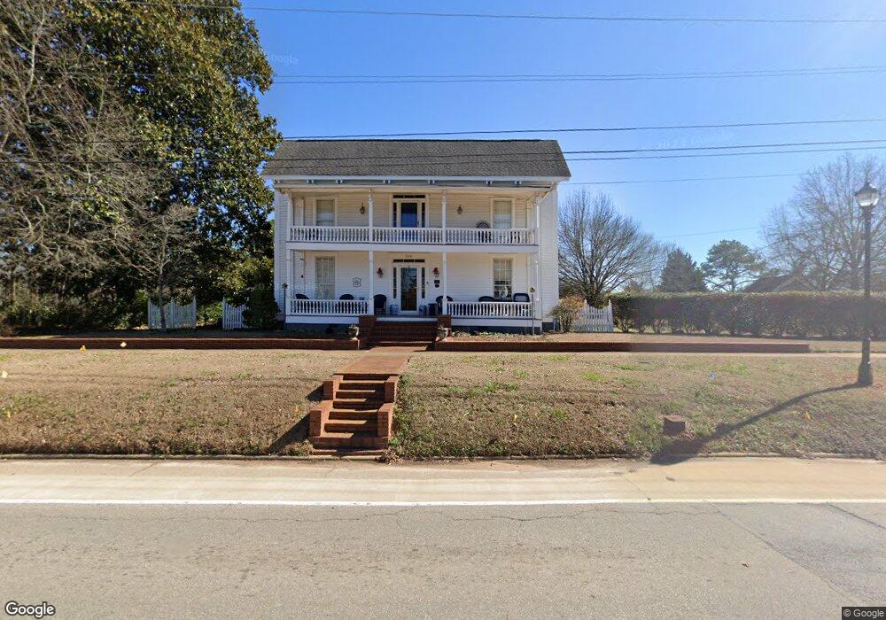
266 S Cherokee Rd Social Circle, GA 30025
Estimated Value: $265,802 - $527,000
--
Bed
--
Bath
2,697
Sq Ft
$135/Sq Ft
Est. Value
About This Home
This home is located at 266 S Cherokee Rd, Social Circle, GA 30025 and is currently estimated at $363,201, approximately $134 per square foot. 266 S Cherokee Rd is a home with nearby schools including Social Circle Primary School, Social Circle Elementary School, and Social Circle Middle School.
Ownership History
Date
Name
Owned For
Owner Type
Purchase Details
Closed on
Feb 26, 2021
Sold by
Lyon Betty B
Bought by
Lyon Betty B and Lyon Alisa
Current Estimated Value
Purchase Details
Closed on
Dec 29, 2003
Sold by
Joseph Kemal T and Joseph Diana
Bought by
Lyon Betty B
Purchase Details
Closed on
Apr 28, 1995
Sold by
Rollins Beverly Jean
Bought by
Kemal Joseph
Purchase Details
Closed on
Jan 12, 1993
Bought by
Rollins Beverly Jean B
Create a Home Valuation Report for This Property
The Home Valuation Report is an in-depth analysis detailing your home's value as well as a comparison with similar homes in the area
Home Values in the Area
Average Home Value in this Area
Purchase History
| Date | Buyer | Sale Price | Title Company |
|---|---|---|---|
| Lyon Betty B | -- | -- | |
| Lyon Betty B | $295,200 | -- | |
| Kemal Joseph | $125,000 | -- | |
| Rollins Beverly Jean B | -- | -- |
Source: Public Records
Mortgage History
| Date | Status | Borrower | Loan Amount |
|---|---|---|---|
| Closed | Kemal Joseph | $0 |
Source: Public Records
Tax History Compared to Growth
Tax History
| Year | Tax Paid | Tax Assessment Tax Assessment Total Assessment is a certain percentage of the fair market value that is determined by local assessors to be the total taxable value of land and additions on the property. | Land | Improvement |
|---|---|---|---|---|
| 2024 | $1,489 | $83,604 | $19,520 | $64,084 |
| 2023 | $635 | $83,004 | $19,520 | $63,484 |
| 2022 | $785 | $79,364 | $19,520 | $59,844 |
| 2021 | $716 | $72,764 | $19,520 | $53,244 |
| 2020 | $727 | $72,044 | $19,520 | $52,524 |
| 2019 | $721 | $69,044 | $19,520 | $49,524 |
| 2018 | $709 | $69,044 | $19,520 | $49,524 |
| 2017 | $2,885 | $69,044 | $19,520 | $49,524 |
| 2016 | $663 | $62,500 | $19,520 | $42,980 |
| 2015 | $655 | $62,500 | $19,520 | $42,980 |
| 2014 | -- | $64,380 | $19,520 | $44,860 |
Source: Public Records
Map
Nearby Homes
- 207 E Hightower Trail
- 135 N Dogwood Ave
- 241 E Ash St
- 127 Holly St NE
- 159 S Forest Ave
- Adrian Plan at Conner Springs
- Sinclair Plan at Conner Springs
- Shiloh Plan at Conner Springs
- Mira Plan at Conner Springs
- Hemingway Plan at Conner Springs
- Harding Plan at Conner Springs
- Tucker Front Porch Plan at Conner Springs
- 357 W Hightower Trail
- 582 S Cherokee Rd
- 432 Chestnut St
- 304 Dogwood Ave
- 177 ORWELL Drive
- 603 Lakewood Dr SW
- 381 Crossroads Dr
- 413 Crossroads Dr
- 219 S Cherokee Rd
- 274 S Cherokee Rd
- 284 S Cherokee Rd Unit 3
- 284 S Cherokee Rd
- 235 S Cherokee Rd
- 292 S Cherokee Rd
- 298 S Cherokee Rd
- 170 S Cherokee Rd
- 304 S Cherokee Rd
- 149 Sycamore St
- 301 S Cherokee Rd
- 0 E Sycamore St Unit 8329345
- E E Sycamore St
- 305 S Cherokee Rd
- 127 Hickory St SW
- 136 E Sycamore St
- 136 Sycamore St
- 145 Hickory St SW
- 315 S Cherokee Rd
- 137 Hickory St SW