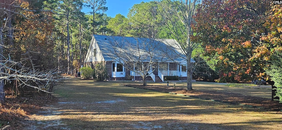

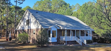
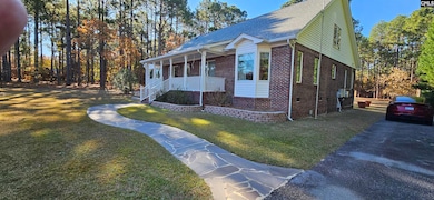


266 Shumpert Rd West Columbia, SC 29172
Pine Ridge NeighborhoodEstimated payment $2,632/month
Highlights
- Very Popular Property
- 2.59 Acre Lot
- Deck
- Solar Power System
- Cape Cod Architecture
- Main Floor Primary Bedroom
About This Home
THIS HOME IS A "MUST SEE"!Absolutely beautiful home on 2.59 acres. First floor is 2548 sq. ft. and has 3 bedrooms, 2 full and 1 half baths. No need for repairs here. Home is in tremendous condition. All windows recently replaced. Luxury vinyl planking recent installed. Huge deck on rear was just replaced in the fall of 2025. Fresh paint throughout. Nice eat-in kitchen with quartz counters, beautiful backsplash, pantry and island. Master bedroom has walk-in closet with built-ins. Master bath has separate vanities with quartz tops and a linen closet. Second bedroom has walk-in closet and shared bath. Third bedroom has walk-in closet. Office/bedroom (no closet) has half bath.Second floor is 1004 sq. ft. and consists of one large open space with a half bath and tremendous storage space. You can configure this space to fit your needs.Home has central vacuum system. 6.48 kWp solar panels installed in 2020. Tesla Powerwall II 13.5 kWh battery installed 5/2021. Full sprinklers in front and partial in rear. 3 sheds and covered woodshed. Walking trail in back area. Disclaimer: CMLS has not reviewed and, therefore, does not endorse vendors who may appear in listings.
Home Details
Home Type
- Single Family
Est. Annual Taxes
- $1,054
Year Built
- Built in 1999
Lot Details
- 2.59 Acre Lot
- Northeast Facing Home
- Sprinkler System
Home Design
- Cape Cod Architecture
- Brick Front
Interior Spaces
- 3,550 Sq Ft Home
- 2-Story Property
- Central Vacuum
- Built-In Features
- Ceiling Fan
- Double Pane Windows
- Bay Window
- Home Office
- Crawl Space
- Fire and Smoke Detector
Kitchen
- Eat-In Kitchen
- Convection Oven
- Gas Cooktop
- Dishwasher
- Kitchen Island
- Quartz Countertops
- Tiled Backsplash
Flooring
- Carpet
- Luxury Vinyl Plank Tile
Bedrooms and Bathrooms
- 4 Bedrooms
- Primary Bedroom on Main
- Walk-In Closet
- Dual Vanity Sinks in Primary Bathroom
- Separate Shower
Laundry
- Laundry on main level
- Dryer
- Washer
Attic
- Storage In Attic
- Attic Access Panel
Eco-Friendly Details
- Solar Power System
Outdoor Features
- Deck
- Covered Patio or Porch
- Shed
- Rain Gutters
Schools
- Wood Elementary School
- Pine Ridge Middle School
- Airport High School
Utilities
- Central Heating and Cooling System
- Mini Split Air Conditioners
- Vented Exhaust Fan
- Mini Split Heat Pump
- Well
- Gas Water Heater
- Septic System
- Cable TV Available
Community Details
- No Home Owners Association
Map
Home Values in the Area
Average Home Value in this Area
Tax History
| Year | Tax Paid | Tax Assessment Tax Assessment Total Assessment is a certain percentage of the fair market value that is determined by local assessors to be the total taxable value of land and additions on the property. | Land | Improvement |
|---|---|---|---|---|
| 2024 | $1,054 | $10,276 | $1,656 | $8,620 |
| 2023 | $1,054 | $10,276 | $1,656 | $8,620 |
| 2022 | $1,432 | $10,276 | $1,656 | $8,620 |
| 2020 | $1,450 | $10,276 | $1,656 | $8,620 |
| 2019 | $1,469 | $10,203 | $1,656 | $8,547 |
| 2018 | $1,489 | $10,203 | $1,656 | $8,547 |
| 2017 | $1,433 | $10,203 | $1,656 | $8,547 |
| 2016 | $1,181 | $8,178 | $1,656 | $6,522 |
| 2014 | $873 | $8,845 | $1,243 | $7,602 |
| 2013 | -- | $8,850 | $1,240 | $7,610 |
Property History
| Date | Event | Price | List to Sale | Price per Sq Ft |
|---|---|---|---|---|
| 12/07/2025 12/07/25 | For Sale | $485,000 | -- | $137 / Sq Ft |
Purchase History
| Date | Type | Sale Price | Title Company |
|---|---|---|---|
| Special Warranty Deed | $150,000 | -- | |
| Legal Action Court Order | $197,700 | -- |
Mortgage History
| Date | Status | Loan Amount | Loan Type |
|---|---|---|---|
| Open | $135,000 | Future Advance Clause Open End Mortgage |
Source: Consolidated MLS (Columbia MLS)
MLS Number: 622924
APN: 007835-01-039
Disclaimer: Certain information contained herein is derived from information provided by parties other than Homes.com. All information provided is deemed reliable, but is not guaranteed to be accurate and should be independently verified.
![]() IDX information is provided exclusively for personal, non-commercial use, and may not be used for any purpose other than to identify prospective properties consumers may be interested in purchasing. Information is deemed reliable but not guaranteed.
IDX information is provided exclusively for personal, non-commercial use, and may not be used for any purpose other than to identify prospective properties consumers may be interested in purchasing. Information is deemed reliable but not guaranteed.
- 268 Shumpert Rd
- 100 Marilyn Ln
- 130 Mary Dr
- 141 Shumpert Rd
- 112 Preakness Ct
- 2140 Sandy Run Dr
- 2105 Sandy Run Dr
- 2020 Sandy Run Dr
- 107 Bunker Dr
- 500 Calcutta Dr
- 119 Hartford Place
- 204 Calcutta Dr
- 1916 Capitol View Rd
- 3109 Bachman Rd
- 2128 Glenn Rd
- 2108 Oak Top Dr
- 256 Calcutta Dr
- 342 Calcutta Dr
- 4156 Bachman Rd
- 273 Sandy Valley Ct
- 204 Long Iron Ct
- 520 Richmond Rd
- 1150 Ramblin Rd
- 161 Kings Tree Acres Dr
- 2490 Fish Hatchery Rd
- 400 Ball Park Rd
- 2309 Windsor Rd
- 1206 N Eden Dr
- 1137 Fort Congaree Trail
- 346 Sprahler St
- 2805 Shadblow Ln
- 1803 Frink St
- 3308 Oakdale Rd
- 1 Bradley Ct
- 2520 Stonehenge Dr
- 1513 Dunbar Rd
- 146 Plum Orchard Dr
- 1136 Charlotte St
- 207 Coronado Rd
- 1119 Ederbach Dr
