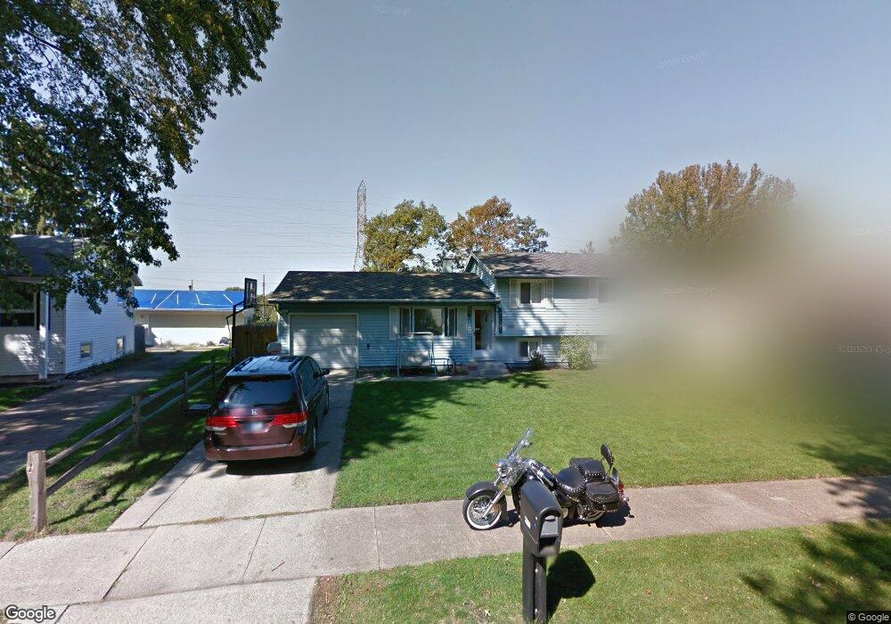
2660 Prescott Dr Mishawaka, IN 46544
Estimated Value: $209,000 - $260,000
2
Beds
2
Baths
1,462
Sq Ft
$160/Sq Ft
Est. Value
About This Home
This home is located at 2660 Prescott Dr, Mishawaka, IN 46544 and is currently estimated at $233,365, approximately $159 per square foot. 2660 Prescott Dr is a home located in St. Joseph County with nearby schools including Fred J. Hums Elementary School, John J. Young Middle School, and Mishawaka High School.
Ownership History
Date
Name
Owned For
Owner Type
Purchase Details
Closed on
Nov 30, 2006
Sold by
Patzschke Barbara A
Bought by
Moore Wayne A and Moore Kristy A
Current Estimated Value
Home Financials for this Owner
Home Financials are based on the most recent Mortgage that was taken out on this home.
Original Mortgage
$17,400
Outstanding Balance
$11,537
Interest Rate
8.37%
Mortgage Type
Adjustable Rate Mortgage/ARM
Estimated Equity
$221,828
Create a Home Valuation Report for This Property
The Home Valuation Report is an in-depth analysis detailing your home's value as well as a comparison with similar homes in the area
Home Values in the Area
Average Home Value in this Area
Purchase History
| Date | Buyer | Sale Price | Title Company |
|---|---|---|---|
| Moore Wayne A | -- | Metropolitan Title In Llc |
Source: Public Records
Mortgage History
| Date | Status | Borrower | Loan Amount |
|---|---|---|---|
| Open | Moore Wayne A | $17,400 |
Source: Public Records
Tax History Compared to Growth
Tax History
| Year | Tax Paid | Tax Assessment Tax Assessment Total Assessment is a certain percentage of the fair market value that is determined by local assessors to be the total taxable value of land and additions on the property. | Land | Improvement |
|---|---|---|---|---|
| 2024 | $2,315 | $205,700 | $55,200 | $150,500 |
| 2023 | $2,250 | $183,600 | $55,200 | $128,400 |
| 2022 | $2,250 | $183,600 | $55,200 | $128,400 |
| 2021 | $1,753 | $141,600 | $23,800 | $117,800 |
| 2020 | $1,641 | $130,400 | $18,500 | $111,900 |
| 2019 | $1,498 | $119,800 | $17,000 | $102,800 |
| 2018 | $1,365 | $99,000 | $14,000 | $85,000 |
| 2017 | $1,183 | $92,400 | $14,000 | $78,400 |
| 2016 | $1,136 | $92,600 | $14,000 | $78,600 |
| 2014 | $1,219 | $101,000 | $14,000 | $87,000 |
Source: Public Records
Map
Nearby Homes
- 14332 Harrison Rd
- 1315 Providence Ct
- 2603 Dawes Place
- 2406 E 9th St
- 1529 Hampton Ct
- 0 Capital Avenue at E 5th St St
- 1556 Conant Ct
- 1568 Blanchard Dr
- 1101 Wellsley Ct
- 347 S Brook Ave
- 1119 Warrington Ct
- 3421 Westborough Dr
- 3362 York St
- 3811 Dudley Dr
- 13511 E 6th St
- 2828 Lincolnway E
- 102 Downey Ave
- 2526 Riviera Dr
- 213 Alford St
- 2310 Homewood Ave
- 2666 Prescott Dr
- 2656 Prescott Dr
- 2650 Prescott Dr
- 2670 Prescott Dr
- 2661 Prescott Dr
- 2653 Prescott Dr
- 2669 Prescott Dr
- 2674 Prescott Dr
- 2641 Prescott Dr
- 2702 Prescott Dr
- 2638 Prescott Dr
- 2635 Prescott Dr
- 2673 Prescott Dr
- 2648 Castine Walk
- 2640 Castine Walk
- 2654 Castine Walk
- 2632 Castine Walk
- 2708 Prescott Dr
- 2630 Castine Walk
- 2623 Prescott Dr