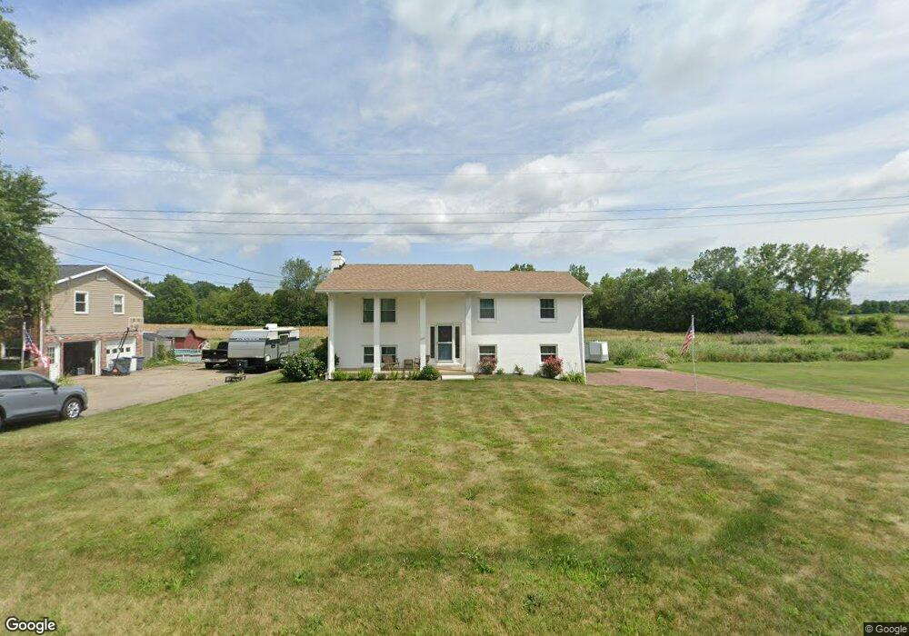
2661 Eaver St NW Uniontown, OH 44685
Estimated Value: $226,427 - $252,000
3
Beds
2
Baths
1,144
Sq Ft
$210/Sq Ft
Est. Value
About This Home
This home is located at 2661 Eaver St NW, Uniontown, OH 44685 and is currently estimated at $240,607, approximately $210 per square foot. 2661 Eaver St NW is a home located in Stark County with nearby schools including North Canton Middle School, Hoover High School, and Lake Center Christian School.
Ownership History
Date
Name
Owned For
Owner Type
Purchase Details
Closed on
Sep 11, 2003
Sold by
Lowe Ronald W and Lowe Marilyn S
Bought by
Nesline Mark D and Nesline Lisa M
Current Estimated Value
Home Financials for this Owner
Home Financials are based on the most recent Mortgage that was taken out on this home.
Original Mortgage
$129,960
Interest Rate
6.18%
Mortgage Type
FHA
Create a Home Valuation Report for This Property
The Home Valuation Report is an in-depth analysis detailing your home's value as well as a comparison with similar homes in the area
Home Values in the Area
Average Home Value in this Area
Purchase History
| Date | Buyer | Sale Price | Title Company |
|---|---|---|---|
| Nesline Mark D | $132,000 | -- |
Source: Public Records
Mortgage History
| Date | Status | Borrower | Loan Amount |
|---|---|---|---|
| Closed | Nesline Mark D | $129,960 |
Source: Public Records
Tax History Compared to Growth
Tax History
| Year | Tax Paid | Tax Assessment Tax Assessment Total Assessment is a certain percentage of the fair market value that is determined by local assessors to be the total taxable value of land and additions on the property. | Land | Improvement |
|---|---|---|---|---|
| 2025 | -- | $69,270 | $17,500 | $51,770 |
| 2024 | -- | $69,270 | $17,500 | $51,770 |
| 2023 | $3,135 | $57,230 | $14,600 | $42,630 |
| 2022 | $1,506 | $57,230 | $14,600 | $42,630 |
| 2021 | $3,096 | $57,230 | $14,600 | $42,630 |
| 2020 | $2,782 | $46,830 | $11,760 | $35,070 |
| 2019 | $2,612 | $46,830 | $11,760 | $35,070 |
| 2018 | $2,705 | $46,830 | $11,760 | $35,070 |
| 2017 | $1,980 | $35,740 | $10,920 | $24,820 |
| 2016 | $1,987 | $35,740 | $10,920 | $24,820 |
| 2015 | $1,996 | $35,740 | $10,920 | $24,820 |
| 2014 | $1,842 | $31,120 | $9,490 | $21,630 |
| 2013 | $921 | $31,120 | $9,490 | $21,630 |
Source: Public Records
Map
Nearby Homes
- 3026 Wright Rd NW
- 9760 Summerset Ave NW
- 3048 Wright Rd NW
- 10531 Newbury Ave NW
- 10044 Cleveland Ave NW
- 10380 Sudbury Cir NW
- 2709 Country Squire St NW
- 3047 Chalford Cir NW Unit 46B
- 9520-9570 Cleveland Ave NW
- 3322 Perrydale St NW
- 9364 Pheasant Valley Ave NW
- 1771 Midway St NW
- 9276 Shipton Cir NW
- 0 Heckman St NW Unit 5154708
- 9120 Bletchley Ave NW
- 11316 Cleveland Ave NW
- 8835 Blitzen Rd NW
- 11056 Peach Glen Ave NW
- 2441 W Bent Oak Cir
- 11065 Dunsby Ave NW
- 2685 Eaver St NW
- 2707 Eaver St NW
- 2621 Eaver St NW
- 2660 Eaver St NW
- 2678 Eaver St NW
- 2642 Eaver St NW
- 2717 Eaver St NW
- 2700 Eaver St NW
- 2626 Eaver St NW
- 2728 Eaver St NW
- 2608 Eaver St NW
- 2745 Eaver St NW
- 2740 Eaver St NW
- 2588 Eaver St NW
- 2663 Brouse St NW
- 2677 Brouse St NW
- 2701 Brouse St NW
- 2645 Brouse St NW
- 2627 Brouse St NW
- 2717 Brouse St NW