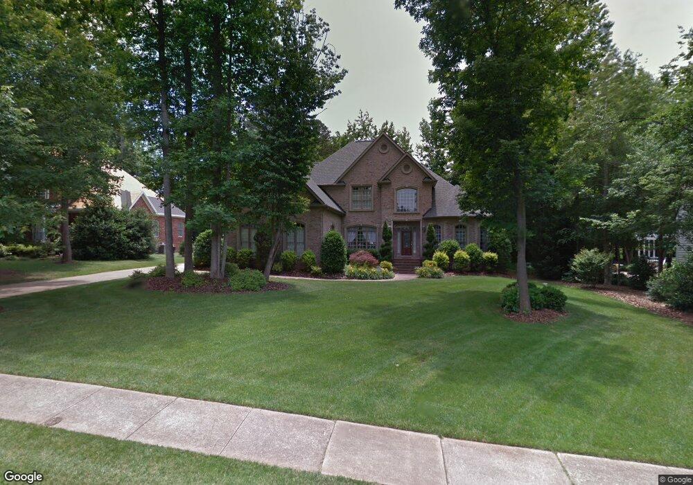
2662 Landing Pointe Dr Clover, SC 29710
Estimated Value: $799,000 - $934,631
--
Bed
1
Bath
3,753
Sq Ft
$232/Sq Ft
Est. Value
About This Home
This home is located at 2662 Landing Pointe Dr, Clover, SC 29710 and is currently estimated at $870,158, approximately $231 per square foot. 2662 Landing Pointe Dr is a home located in York County with nearby schools including Oakridge Elementary School, Oakridge Middle School, and Clover High School.
Ownership History
Date
Name
Owned For
Owner Type
Purchase Details
Closed on
Oct 9, 2025
Sold by
Master In Equity For York County
Bought by
Sands Lisa G
Current Estimated Value
Purchase Details
Closed on
May 6, 2008
Sold by
Barry John B
Bought by
Sands Lisa G
Purchase Details
Closed on
Oct 24, 2002
Sold by
Tony H Forouzad Construction Co Inc
Bought by
Barry John B
Purchase Details
Closed on
Jul 18, 2001
Sold by
Crescent Resources Llc
Bought by
Tony H Farouzad Construction Co Inc
Create a Home Valuation Report for This Property
The Home Valuation Report is an in-depth analysis detailing your home's value as well as a comparison with similar homes in the area
Home Values in the Area
Average Home Value in this Area
Purchase History
| Date | Buyer | Sale Price | Title Company |
|---|---|---|---|
| Sands Lisa G | -- | None Listed On Document | |
| Sands Lisa G | -- | None Available | |
| Barry John B | $469,000 | -- | |
| Tony H Farouzad Construction Co Inc | $62,500 | -- |
Source: Public Records
Tax History Compared to Growth
Tax History
| Year | Tax Paid | Tax Assessment Tax Assessment Total Assessment is a certain percentage of the fair market value that is determined by local assessors to be the total taxable value of land and additions on the property. | Land | Improvement |
|---|---|---|---|---|
| 2025 | $3,465 | $25,307 | $2,727 | $22,580 |
| 2024 | $3,109 | $22,005 | $3,000 | $19,005 |
| 2023 | $3,189 | $22,005 | $3,000 | $19,005 |
| 2022 | $2,628 | $22,005 | $3,000 | $19,005 |
| 2021 | -- | $22,005 | $3,000 | $19,005 |
| 2020 | $2,494 | $24,260 | $0 | $0 |
| 2019 | $2,527 | $20,460 | $0 | $0 |
| 2018 | $2,539 | $20,460 | $0 | $0 |
| 2017 | $2,365 | $20,460 | $0 | $0 |
| 2016 | $2,228 | $20,460 | $0 | $0 |
| 2014 | $2,549 | $20,460 | $3,000 | $17,460 |
| 2013 | $2,549 | $22,360 | $3,000 | $19,360 |
Source: Public Records
Map
Nearby Homes
- 304 Inland Cove Ct
- 319 Inland Cove Ct
- 2678 Landing Pointe Dr
- 1727 Mineral Springs Rd
- 1921 Notchwood Ct
- 2323 Branch Hill Ln
- 2180 Shady Pond Dr
- 5000 Mill Creek Rd
- 450 Battery Cir
- 1437 Harpers Inlet Dr
- 2099 Shady Pond Dr
- 2095 Shady Pond Dr
- 431 Battery Cir
- 743 Waterfall Way
- 126 Misty Woods Dr
- 0000 Senator Rd
- 121 Misty Woods Dr
- 335 Carroll Cove
- 1032 Valley Forge Dr
- 370 Battery Cir Unit 20
- 2666 Landing Pointe Dr
- 2666 Landing Pointe Dr Unit 71
- 2658 Landing Pointe Dr
- 307 Inland Cove Ct
- 700 Kingsmill Ln
- 311 Inland Cove Ct
- 704 Kingsmill Ln
- 500 Shadow Cove Ln
- 501 Shadow Cove Ln
- 315 Inland Cove Ct
- 504 Shadow Cove Ln
- 300 Inland Cove Ct
- 903 Thorn Ridge Ln
- 708 Kingsmill Ln
- 505 Shadow Cove Ln
- 308 Inland Cove Ct
- 2674 Landing Pointe Dr
- 312 Inland Cove Ct
- 319 Inland Cove Ct Unit 77
- 316 Inland Cove Ct