Estimated Value: $379,000 - $426,000
4
Beds
4
Baths
2,288
Sq Ft
$171/Sq Ft
Est. Value
About This Home
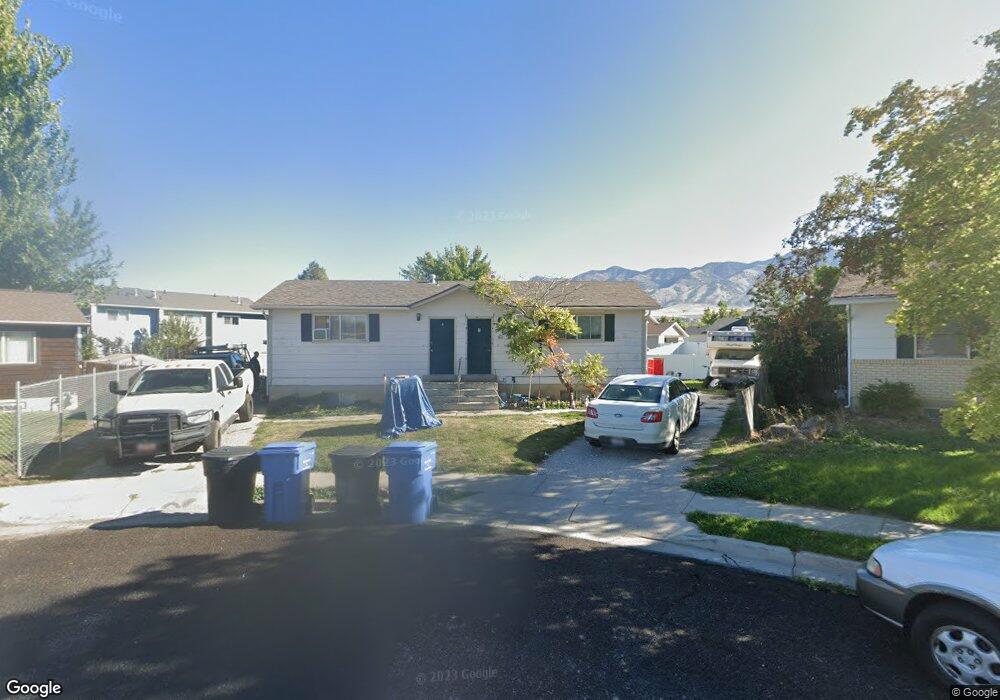
This home is located at 2662 N 370 E, Logan, UT 84341 and is currently estimated at $392,031, approximately $171 per square foot. 2662 N 370 E is a home located in Cache County with nearby schools including Greenville School, Cedar Ridge School, and North Cache Middle School.
Ownership History
Date
Name
Owned For
Owner Type
Purchase Details
Closed on
Jul 21, 2020
Sold by
Beatty Bryce James
Bought by
Oak Brooks Llc
Current Estimated Value
Home Financials for this Owner
Home Financials are based on the most recent Mortgage that was taken out on this home.
Original Mortgage
$198,375
Outstanding Balance
$175,513
Interest Rate
3.1%
Mortgage Type
New Conventional
Estimated Equity
$216,518
Purchase Details
Closed on
Oct 4, 2006
Sold by
Merrill Kendal E and Merrill Cathy D
Bought by
Merrill Kendal and Merrill Cathy
Create a Home Valuation Report for This Property
The Home Valuation Report is an in-depth analysis detailing your home's value as well as a comparison with similar homes in the area
Home Values in the Area
Average Home Value in this Area
Purchase History
| Date | Buyer | Sale Price | Title Company |
|---|---|---|---|
| Oak Brooks Llc | -- | American Secure Title Logan | |
| Beatty Bryce James | -- | Vanguard Title Ins Agcy Llc | |
| Merrill Kendal | -- | None Available |
Source: Public Records
Mortgage History
| Date | Status | Borrower | Loan Amount |
|---|---|---|---|
| Open | Beatty Bryce James | $198,375 |
Source: Public Records
Tax History
| Year | Tax Paid | Tax Assessment Tax Assessment Total Assessment is a certain percentage of the fair market value that is determined by local assessors to be the total taxable value of land and additions on the property. | Land | Improvement |
|---|---|---|---|---|
| 2025 | $1,400 | $356,210 | $158,100 | $198,110 |
| 2024 | $1,504 | $356,210 | $158,100 | $198,110 |
| 2023 | $1,613 | $353,110 | $155,000 | $198,110 |
| 2022 | $1,473 | $308,110 | $110,000 | $198,110 |
| 2021 | $163 | $290,100 | $110,000 | $180,100 |
| 2020 | $1,299 | $217,000 | $75,000 | $142,000 |
| 2019 | $1,360 | $217,000 | $75,000 | $142,000 |
| 2018 | $1,218 | $188,168 | $55,000 | $133,168 |
| 2017 | $1,077 | $87,550 | $0 | $0 |
| 2016 | $1,094 | $87,550 | $0 | $0 |
| 2015 | $1,099 | $87,550 | $0 | $0 |
| 2014 | $1,074 | $87,550 | $0 | $0 |
| 2013 | -- | $78,740 | $0 | $0 |
Source: Public Records
Map
Nearby Homes
- 2640 N Aspen Park Ln
- 2592 N 330 E
- 623 E 2475 N Unit 5
- 645 E 2475 N
- 667 E 2475 N
- 2460 N 200 E
- 2452 N 200 E
- 2469 N 620 E Unit 3
- 2477 N 620 E Unit 4
- 161 E 2440 N
- 680 S 50 E Unit 112
- 385 E 2280 N Unit D
- 2070 U S 91
- 327 E 2230 N Unit A
- 2807 N Main St
- 276 W 450 S
- 2284 N 740 E
- 210 S 100 W
- 741 E 2200 N
- 400 W 3100 N
Your Personal Tour Guide
Ask me questions while you tour the home.