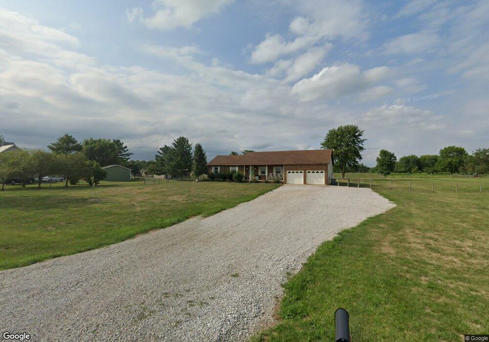
2662 Weigand Rd Lockbourne, OH 43137
Estimated Value: $412,000 - $616,000
3
Beds
2
Baths
1,678
Sq Ft
$277/Sq Ft
Est. Value
About This Home
This home is located at 2662 Weigand Rd, Lockbourne, OH 43137 and is currently estimated at $464,535, approximately $276 per square foot. 2662 Weigand Rd is a home located in Pickaway County.
Ownership History
Date
Name
Owned For
Owner Type
Purchase Details
Closed on
Dec 17, 2020
Sold by
Brown Patricia
Bought by
Brown Christopher R
Current Estimated Value
Home Financials for this Owner
Home Financials are based on the most recent Mortgage that was taken out on this home.
Original Mortgage
$206,000
Outstanding Balance
$181,278
Interest Rate
2.7%
Mortgage Type
New Conventional
Estimated Equity
$283,257
Purchase Details
Closed on
Jun 26, 2019
Sold by
Walton William H and Walton Patti S
Bought by
Brown Chris and Brown Patricia
Home Financials for this Owner
Home Financials are based on the most recent Mortgage that was taken out on this home.
Original Mortgage
$203,500
Interest Rate
5.62%
Mortgage Type
FHA
Create a Home Valuation Report for This Property
The Home Valuation Report is an in-depth analysis detailing your home's value as well as a comparison with similar homes in the area
Purchase History
| Date | Buyer | Sale Price | Title Company |
|---|---|---|---|
| Brown Christopher R | -- | Northwest Advantage Title Ag | |
| Brown Chris | -- | Northwest Ttl Fam Companies |
Source: Public Records
Mortgage History
| Date | Status | Borrower | Loan Amount |
|---|---|---|---|
| Open | Brown Christopher R | $206,000 | |
| Closed | Brown Chris | $203,500 |
Source: Public Records
Tax History
| Year | Tax Paid | Tax Assessment Tax Assessment Total Assessment is a certain percentage of the fair market value that is determined by local assessors to be the total taxable value of land and additions on the property. | Land | Improvement |
|---|---|---|---|---|
| 2025 | $4,977 | $100,730 | $28,350 | $72,380 |
| 2024 | $4,977 | $100,730 | $28,350 | $72,380 |
| 2023 | $3,823 | $100,730 | $28,350 | $72,380 |
| 2022 | $3,478 | $84,010 | $23,310 | $60,700 |
| 2021 | $3,293 | $84,010 | $23,310 | $60,700 |
| 2020 | $3,297 | $84,010 | $23,310 | $60,700 |
| 2019 | $2,607 | $64,590 | $22,330 | $42,260 |
| 2018 | $2,641 | $64,590 | $22,330 | $42,260 |
| 2017 | $2,720 | $64,590 | $22,330 | $42,260 |
| 2016 | $2,594 | $61,330 | $21,350 | $39,980 |
| 2015 | $2,596 | $61,330 | $21,350 | $39,980 |
| 2014 | $2,597 | $61,330 | $21,350 | $39,980 |
| 2013 | $2,859 | $65,280 | $21,350 | $43,930 |
Source: Public Records
Map
Nearby Homes
- 54 Cider Mill Dr
- 57 Cider Mill Dr
- 62 Cider Mill Dr
- 61 Cider Mill Dr
- 59 Cider Mill Dr
- 44 Cider Mill Dr
- 60 Cider Mill Dr
- 50 Cider Mill Dr
- 53 Cider Mill Dr
- 3 Grismill Dr
- 11879 Lockbourne Eastern Rd
- 2713 W Old Duvall Ct
- 2767 W Old Duvall Ct
- 39 Thoreau Dr
- 2901 W Old Duvall Ct
- 1 Hemingway Ave
- 3109 E Old Duvall Ct
- 2864 W Old Duvall Ct
- 625 Kildow Ct Unit 625
- 5 Thurber Rd
- 2704 Weigand Rd
- 2630 Weigand Rd
- 2720 Weigand Rd
- 2600 Weigand Rd
- 2542 Weigand Rd
- 2520 Weigand Rd
- 0 Weigand Rd
- 0 Weigand Rd
- 12402 Bulen Pierce Rd
- 12465 Bulen Pierce Rd
- 12417 Bulen Pierce Rd
- 12300 Bulen Pierce Rd
- 12399 Bulen Pierce Rd
- 2415 Weigand Rd
- 2395 Weigand Rd
- 12240 Bulen Pierce Rd
- 12313 Bulen Pierce Rd
- 2358 Weigand Rd
- 2363 Weigand Rd
- 12206 Bulen Pierce Rd
Your Personal Tour Guide
Ask me questions while you tour the home.