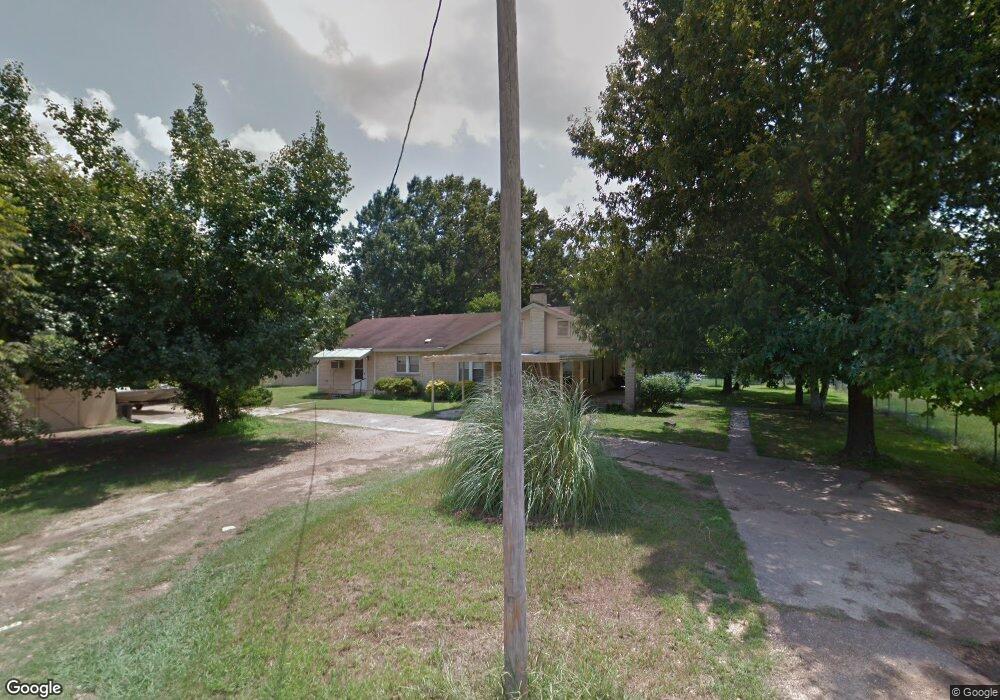
2663 Highway 79 N Camden, AR 71701
Estimated Value: $69,000 - $137,000
3
Beds
2
Baths
1,936
Sq Ft
$60/Sq Ft
Est. Value
About This Home
This home is located at 2663 Highway 79 N, Camden, AR 71701 and is currently estimated at $116,427, approximately $60 per square foot. 2663 Highway 79 N is a home located in Ouachita County with nearby schools including Harmony Grove Elementary School, Sparkman Elementary School, and Sparkman K-12 School.
Ownership History
Date
Name
Owned For
Owner Type
Purchase Details
Closed on
Aug 14, 2019
Sold by
Nationstar Mortgage Llc
Bought by
Rabion Billy J and Rabion Ladonya C
Current Estimated Value
Purchase Details
Closed on
Apr 8, 2019
Sold by
Ouachita County Commissioner
Bought by
Nationstar Mortgage Llc
Purchase Details
Closed on
Sep 30, 2011
Sold by
Treadaway Kenneth and Treadaway Jean
Bought by
Campbell Jone L
Home Financials for this Owner
Home Financials are based on the most recent Mortgage that was taken out on this home.
Original Mortgage
$74,093
Interest Rate
4.28%
Create a Home Valuation Report for This Property
The Home Valuation Report is an in-depth analysis detailing your home's value as well as a comparison with similar homes in the area
Home Values in the Area
Average Home Value in this Area
Purchase History
| Date | Buyer | Sale Price | Title Company |
|---|---|---|---|
| Rabion Billy J | $24,750 | Bright Line Title Llc | |
| Nationstar Mortgage Llc | $56,961 | None Available | |
| Campbell Jone L | $72,000 | -- |
Source: Public Records
Mortgage History
| Date | Status | Borrower | Loan Amount |
|---|---|---|---|
| Previous Owner | Campbell Jone L | $74,093 |
Source: Public Records
Tax History Compared to Growth
Tax History
| Year | Tax Paid | Tax Assessment Tax Assessment Total Assessment is a certain percentage of the fair market value that is determined by local assessors to be the total taxable value of land and additions on the property. | Land | Improvement |
|---|---|---|---|---|
| 2024 | $850 | $15,680 | $770 | $14,910 |
| 2023 | $850 | $15,680 | $770 | $14,910 |
| 2022 | $850 | $15,680 | $770 | $14,910 |
| 2021 | $850 | $15,680 | $770 | $14,910 |
| 2020 | $850 | $15,390 | $530 | $14,860 |
| 2019 | $834 | $15,390 | $530 | $14,860 |
| 2018 | $834 | $15,390 | $530 | $14,860 |
| 2017 | $834 | $15,390 | $530 | $14,860 |
| 2016 | $834 | $15,390 | $530 | $14,860 |
| 2015 | $748 | $15,390 | $530 | $14,860 |
| 2014 | $761 | $15,660 | $800 | $14,860 |
Source: Public Records
Map
Nearby Homes
- 108 Oak
- 112 Oak St
- 295 Ouachita 45
- 180 Ouachita 404
- 161 Ouachita 406
- Lots Jonquil
- 101 Shepherd Ave
- 102 Shepherd Ave
- 234 E Busbee St
- 239 E Ingram St
- 115 S Womble Ave
- 429 Maple St
- 437 Maple St
- 306 Alley B
- 500 E Ingram St
- 390 Ouachita 210 Rd
- 770 Ouachita 88
- 19-12s-16w Ouachita Co Ar
- 199 Ouachita 37
- Ouachita Road 437 Unit LotWP001