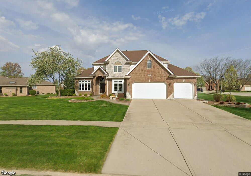
2665 Meadow Path New Lenox, IL 60451
Estimated Value: $552,000 - $598,000
Studio
--
Bath
--
Sq Ft
0.49
Acres
About This Home
This home is located at 2665 Meadow Path, New Lenox, IL 60451 and is currently estimated at $572,809. 2665 Meadow Path is a home located in Will County with nearby schools including Nelson Prairie School, Lincoln Way West, and St. Jude School.
Ownership History
Date
Name
Owned For
Owner Type
Purchase Details
Closed on
Aug 31, 2005
Sold by
Founders Bank
Bought by
Mahoney Joseph M and Mahoney Suzanne C
Current Estimated Value
Home Financials for this Owner
Home Financials are based on the most recent Mortgage that was taken out on this home.
Original Mortgage
$370,320
Outstanding Balance
$196,376
Interest Rate
5.71%
Mortgage Type
Purchase Money Mortgage
Estimated Equity
$376,433
Create a Home Valuation Report for This Property
The Home Valuation Report is an in-depth analysis detailing your home's value as well as a comparison with similar homes in the area
Home Values in the Area
Average Home Value in this Area
Purchase History
| Date | Buyer | Sale Price | Title Company |
|---|---|---|---|
| Mahoney Joseph M | $494,500 | Chicago Title Insurance Co |
Source: Public Records
Mortgage History
| Date | Status | Borrower | Loan Amount |
|---|---|---|---|
| Open | Mahoney Joseph M | $370,320 |
Source: Public Records
Tax History
| Year | Tax Paid | Tax Assessment Tax Assessment Total Assessment is a certain percentage of the fair market value that is determined by local assessors to be the total taxable value of land and additions on the property. | Land | Improvement |
|---|---|---|---|---|
| 2024 | $12,993 | $168,105 | $37,368 | $130,737 |
| 2023 | $12,993 | $153,241 | $34,064 | $119,177 |
| 2022 | $11,696 | $141,171 | $31,381 | $109,790 |
| 2021 | $11,110 | $132,767 | $29,513 | $103,254 |
| 2020 | $10,798 | $128,030 | $28,460 | $99,570 |
| 2019 | $10,339 | $124,061 | $27,578 | $96,483 |
| 2018 | $10,104 | $119,785 | $26,628 | $93,157 |
| 2017 | $9,604 | $116,341 | $25,862 | $90,479 |
| 2016 | $9,326 | $113,227 | $25,170 | $88,057 |
| 2015 | $8,987 | $109,663 | $24,378 | $85,285 |
| 2014 | $8,987 | $108,309 | $24,077 | $84,232 |
| 2013 | $8,987 | $109,769 | $24,402 | $85,367 |
Source: Public Records
Map
Nearby Homes
- 953 Foxwood Ct Unit 953
- 731 Bobwhite Ln
- 2170 Arthurs Pass
- 14620 W Laraway Rd
- 819 Shagbark Rd
- 920 Winter Park Dr Unit 47B
- 2341 Stone Creek Dr
- 2331 Stone Creek Dr
- 2321 Stone Creek Dr
- 2301 Stone Creek Dr
- 2231 Stone Creek Dr
- Galveston Plan at Calistoga
- Westbury Plan at Calistoga
- Brooklyn Plan at Calistoga
- Ontario Plan at Calistoga
- Raleigh Plan at Calistoga
- Siena II Plan at Calistoga
- 1525 Cimarron Dr
- 575 Caledonia Dr
- 1007 Nelson Rd
- 795 Brad Dr
- 760 Moon Vista Ct
- 2664 Meadow Path
- 2634 Foxwood Dr
- 2638 Foxwood Dr Unit 2638
- 2636 Foxwood Dr Unit 2636
- 770 Moon Vista Ct
- 797 Brad Dr Unit 797
- 801 Brad Dr Unit 801
- 751 Moon Vista Ct
- 2642 Meadow Path
- 771 Moon Vista Ct
- 798 Brad Dr
- 761 Moon Vista Ct
- 2624 Foxwood Dr Unit 2624
- 2618 Foxwood Dr Unit 2618
- 2622 Foxwood Dr Unit 2622
- 2620 Foxwood Dr Unit 2620
- 2636 Meadow Path
- 2712 Meadow Path