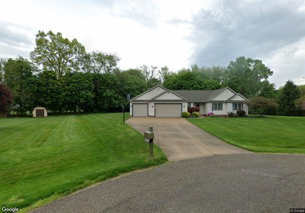
2665 Woodview Rd Uniontown, OH 44685
Estimated Value: $370,104 - $421,000
3
Beds
2
Baths
1,959
Sq Ft
$206/Sq Ft
Est. Value
About This Home
This home is located at 2665 Woodview Rd, Uniontown, OH 44685 and is currently estimated at $402,776, approximately $205 per square foot. 2665 Woodview Rd is a home located in Summit County with nearby schools including Greenwood Elementary School, Green Primary School, and Green Intermediate Elementary School.
Ownership History
Date
Name
Owned For
Owner Type
Purchase Details
Closed on
Apr 28, 1998
Sold by
Charles P Temple Inc
Bought by
Adams Jeffrey L and Adams Melanie L
Current Estimated Value
Home Financials for this Owner
Home Financials are based on the most recent Mortgage that was taken out on this home.
Original Mortgage
$30,000
Outstanding Balance
$5,944
Interest Rate
7.26%
Mortgage Type
New Conventional
Estimated Equity
$396,832
Create a Home Valuation Report for This Property
The Home Valuation Report is an in-depth analysis detailing your home's value as well as a comparison with similar homes in the area
Home Values in the Area
Average Home Value in this Area
Purchase History
| Date | Buyer | Sale Price | Title Company |
|---|---|---|---|
| Adams Jeffrey L | $36,000 | -- |
Source: Public Records
Mortgage History
| Date | Status | Borrower | Loan Amount |
|---|---|---|---|
| Open | Adams Jeffrey L | $30,000 |
Source: Public Records
Tax History Compared to Growth
Tax History
| Year | Tax Paid | Tax Assessment Tax Assessment Total Assessment is a certain percentage of the fair market value that is determined by local assessors to be the total taxable value of land and additions on the property. | Land | Improvement |
|---|---|---|---|---|
| 2025 | $5,314 | $113,520 | $19,464 | $94,056 |
| 2024 | $5,314 | $113,520 | $19,464 | $94,056 |
| 2023 | $5,314 | $113,520 | $19,464 | $94,056 |
| 2022 | $3,984 | $76,476 | $14,417 | $62,059 |
| 2021 | $3,733 | $76,476 | $14,417 | $62,059 |
| 2020 | $4,030 | $84,190 | $14,420 | $69,770 |
| 2019 | $3,436 | $67,260 | $10,400 | $56,860 |
| 2018 | $3,513 | $67,260 | $10,400 | $56,860 |
| 2017 | $3,141 | $67,260 | $10,400 | $56,860 |
| 2016 | $3,126 | $56,470 | $10,400 | $46,070 |
| 2015 | $3,141 | $56,470 | $10,400 | $46,070 |
| 2014 | $3,121 | $56,470 | $10,400 | $46,070 |
| 2013 | $3,232 | $58,120 | $10,400 | $47,720 |
Source: Public Records
Map
Nearby Homes
- 3979 Northdale St NW
- 2830 Superior Dr
- 2771 Superior Dr
- 13704 Greenland Ave NW
- 3796 Sweitzer St NW
- 2944 Sunset Dr
- 0 Pine St NW
- 3003 Myersville Rd
- 2664 Pine Lake Trail
- 2619 Henrietta Dr
- 2577 Sweitzer Rd
- 2864 Pine Lake Rd
- 3310 Linden St NW
- 3135 Northdale St NW
- 3212 Deborah Ct
- 3217 Deborah Ct
- 3100 Linden St NW
- 2811 Canton Rd
- 3221 Killian Rd
- 2575 Myersville Rd
- 2657 Woodview Rd
- 13365 Betty Ave NW
- 2660 Woodview Rd
- 3087 Stonehurst Rd
- 3977 Hugh St NW
- 3099 Stonehurst Rd
- 2652 Woodview Rd
- 13358 Betty Ave NW
- 3075 Stonehurst Rd
- 3075 Stonehurst Rd
- 3081 Stonehurst Rd
- 0 Woodview Rd Unit 3118706
- 0 Woodview Rd Unit 3118701
- 0 Woodview Rd Unit 3118681
- 0 Woodview Rd Unit 4254867
- 0 Woodview Rd Unit 4254804
- 13344 Betty Ave NW
- 3851 Hugh St NW
- 3065 Stonehurst Rd
- 3098 Stonehurst Rd